Wintry Pattern Approaching

Discussion: The sun is low, and the shadows are long. But all in all, it’s actually a nice day out there. I would soak in this last day of mild conditions because a prolonged cold air mass is on the way to ring in the new year. I remember feeling this way in late December 2013 ahead of the historic Arctic outbreak that took place early 2014.
For tonight, I expect conditions to remain dry until at least 6pm. Sometime between 6 and 8pm, spotty showers are expected to approach NJ from the SW and push through to the NE overnight—exiting NE NJ around 2am. I know this doesn’t bode well for the NYC NYE stuff but it is what it is. Given the dynamics I see in the atmosphere and the transitional nature of this system (ending the warmup – beginning the freeze), I wouldn’t be surprised to see some boomers within the scattered spotty nature of tonight’s showers. At the very least, expect spotty downpours and 30-40mph wind gusts, possibly higher. It all clears out early tomorrow (Wednesday) morning and then it’s time to anticipate the colder pattern change.
Wednesday (Jan 1) should feel transitional day. Daytime temps could still spike a little mild but a very different feel after sundown as temps crash and winds contribute to a colder feel. Thursday and beyond, temperatures are expected to stay cold through as far as I can see (at least mid-January). The entire period won’t feature extreme cold but the Jan 8-12 period is one I would watch for the coldest conditions. Whether records get broken or not, it looks like the pipe-bursting stuff during that window. Outside of that window, I think highs in the 20s/30s and lows in the single digits/teens will be common…stuff we have dealt with before but a long period of it.
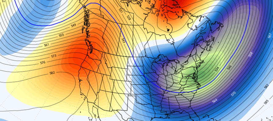
The first snow chance would be around Jan 4 and likely only for SNJ as a weak sliding wave moves through to the S of NJ. Then Jan 6-7 is looking like a larger system that could approach NJ from the W. Then there’s the coastal snowstorm potential around Jan 9-11. I’m still not paying attention to surface model maps, only upper levels and nothing has changed. Careful not to get juked out of your socks run-to-run if you are focusing on surface maps. I am still only putting stock into upper level ensembles and it still looks good IMO. I will be focusing on the above three opportunities once we get closer. For now I am just liking that the expected pattern, favorable for snow development, is holding on model guidance. The above model image (12Z GFS Ensemble mean of 500mb Geopotential height anomalies) illustrates the look that we’ve been discussing for over a week now.
So everyone have a great New Year’s Eve! Stay dry tonight and prepare for cold starting tomorrow night through at least much of January, with ample chances for snow.
In English: Spotty showers, possibly some lightning, are expected tonight between 6pm and just after midnight. Winds should crank up a but during this time as well. Everything clears tomorrow morning, and we then turn all attention to a prolonged cold wintry period with a few snow chances possible through at least mid-January. Happy New Year and be safe! JC
Premium Services
KABOOM Club offers ad-free content, inside info forecast discussion, your questions answered, and early storm impact maps and video releases (ahead of the public). At two bucks per month, it’s an extremely feasible way to show additional support for Weather NJ. Think of it as a tip jar with perks. Available onFacebook or Patreon.
My Pocket Meteorologist (MPM), in partnership with EPAWA Weather Consulting, offers professional/commercial interests, whose businesses depend on outdoor weather conditions (snow plowing, landscaping, construction, etc.), with hyper-local text message alerts/forecasts and access to the MPM premium forum—the most comprehensive and technical forecast discussion available for PA and NJ.
Jonathan Carr (JC) is the founder and sole operator of Weather NJ, New Jersey’s largest independent weather reporting agency. Since 2010, Jonathan has provided weather safety discussion and forecasting services for New Jersey and surrounding areas through the web and social media. Originally branded as Severe NJ Weather (before 2014), Weather NJ is proud to bring you accurate and responsible forecast discussion ahead of high-stakes weather scenarios that impact this great garden state of ours. All Weather. All New Jersey.™ Be safe! JC


