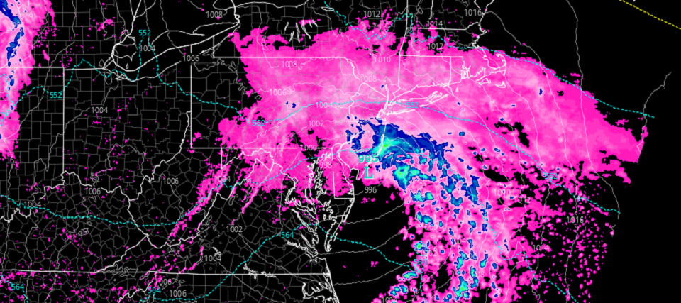
Discussion: Today should remain mostly cloudy with periods of light rain possible. Today rain chances increase some between afternoon and evening and then significantly between evening and overnight/tomorrow morning.
A synoptic surface low, associated with a leading upper-level disturbance, should first track across NC, VA, and Delmarva today before ultimately passing over SENJ tonight/tomorrow morning. This should provide ample lifting for periods of heavy rain to occur between about 9pm tonight and 9am tomorrow morning. SENJ is favored for the most rainfall however the entire state of NJ is on the hook for at least some rain. Here are the expected rain totals (through tomorrow late-morning) from the latest high-res NAM run:
Given the dropping intensity of the surface low and it’s anticipated location with respect to NJ, we could see some high winds especially along the ECNJ/SENJ coasts. These winds would be late tonight through AM hour tomorrow morning. Here are the expected peak wind gusts (around sunrise) tomorrow morning also from the latest high-res NAM run:
Coastal flooding is possible but likely just minor due to the short duration of the event and also low tide occurring during peak wind time. Flash flooding from heavier rainfall, especially in SENJ, seems more probable IMO than coastal flooding.
The next shot at rain, after tonight-tomorrow, is Thursday. A low should be occluding off over the Great Lakes with a cold front pushing E through NJ. It still looks annoyingly cool (for this time of year) through the weekend with April 12 (next Tuesday) still expected to start a warmer stretch.
In English: Today should remain mostly cloudy. Rain should push in as early as sunset but by midnight tonight and then fall heavy through Wednesday morning. Winds should intensify after midnight tonight, especially for coastal areas. Lesser winds away from the ocean. But either way, NJ should expect a rain/windy night tonight with improvement by noon tomorrow. Be safe! JC
Premium Services
KABOOM Club is more for the snow lover or weather nerd who needs inside info with early forecast discussion and storm impact maps (ahead of the public). It’s a bit more complex than what the public sees but offers the “In English” with it. It’s also a way to support Weather NJ with a 99-cent per month contribution.
My Pocket Meteorologist offers commercial interests, whose businesses depend on outdoor weather conditions (snow plowing, landscaping, construction, etc.), with hyper-local text message forecasts and access to the My Pocket Meteorologist premium forum. This information is the most complex analysis available as needed by the outdoor commercial sector.
Jonathan Carr (JC) is the founder and sole operator of Weather NJ, New Jersey’s largest independent weather reporting agency. Since 2010, Jonathan has provided weather safety discussion and forecasting services for New Jersey and surrounding areas through the web and social media. Originally branded as Severe NJ Weather (before 2014), Weather NJ is proud to bring you accurate and responsible forecast discussion ahead of high-stakes weather scenarios that impact this great garden state of ours. All Weather. All New Jersey.™ Be safe! JC
