Weekend Snowstorm Update

Discussion: So the forecast for today through Friday is rather straightforward and easy…cold and windy. During this time, NJ will be positioned under the W side of back building trough. The W side of a trough features colder flow out of Canada and other trough/ridge features further N in Canada are positioned to let the Arctic air flow towards the Mid-Atlantic US (cross polar flow). This Jan 8-12 period was identified in late December as the period of coldest temperatures within the favorable snow pattern and that still holds today. It won’t be record cold (we’re about 15-20 degrees away from that for high and low temps). But it will be cold regardless with most highs staying at or below freezing (only SNJ/SENJ has chance to push just above freezing each day) and most lows down into the teens/lower-20s (statewide). That by itself is not too bad but the persistent W/NW winds will seem relentless into Friday morning, dropping real feel temperatures (wind chill factor) into single digits/teens. Gusty winds of 30-45mph should be common at times starting today. The colder W/NW flow over the Great Lakes could produce far-reaching lake effect snow bands across NY State and PA that could bring anything from flurries to snow showers to NJ in the Tuesday night-Thursday morning time frame including all of Wednesday. Otherwise, sunny, cold, and blustery/gusty should sum up today through Friday morning.
Now let’s move on to the weekend. Once again a quick recap: In late-December, we identified a colder and wintrier pattern that would start around Jan 2 and go at least through Jan 13-14. Within that period, we identified a few storm signals. The first was this past Friday night’s clipper. The second was a signal within the Jan 4-8 period which was yesterday’s SNJ snowstorm where AC down through Cape May saw 5-8 inches of snow while the northern 2/3 of NJ struggled to break out of the 1-2 inch range due to confluence-produced subsidence generated by the first clipper becoming a Newfoundland powerhouse storm. This weekend is the third storm signal that we originally suggested for the Jan 8-12 period. Whatever happens looks to occur this Saturday into Sunday (Jan 11-12).
This weekend system honestly gives me the heebie jeebies. There are shades of resemblance to a few historical snowstorms like January 1996, December 2009, January 2011 and 2018, etc. But there’s also some resemblance to the great Blizzard Bust of January 2015. This is a complex system with a lot of moving parts in the upper atmosphere. Right now we are monitoring cyclonic vorticity to get a sense of how the N and S streams of energy will interact and phase. Whenever a phase is required for a snowstorm to happen, it introduces a lot of wildcard slip potential. Earlier phasing can jack up snow totals and late phasing can allow systems to slip off the coast. It’s hard to ever fully trust a phase, as I painfully have learned with a few systems in the past. But with that said, here’s the phasing synopsis we’re dealing with for this weekend’s snowstorm potential.
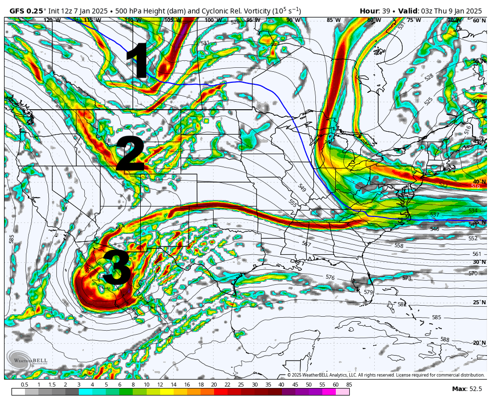
First, a series of vorts (areas of cyclonic energy) will push into the W side of the North American Continent. We’ll label the pieces as 1 – The N stream vort, 2 – The S stream vort and 3 – The SW US upper low. What #1 and #2 do will determine the intensity of the weekend storm. There’s high confidence that the current progressive W US trough breaks off/leaves behind the upper low #3. This is happening today into tomorrow. But here are the players of cyclonic vorticity as defined early in today’s GFS Data run:

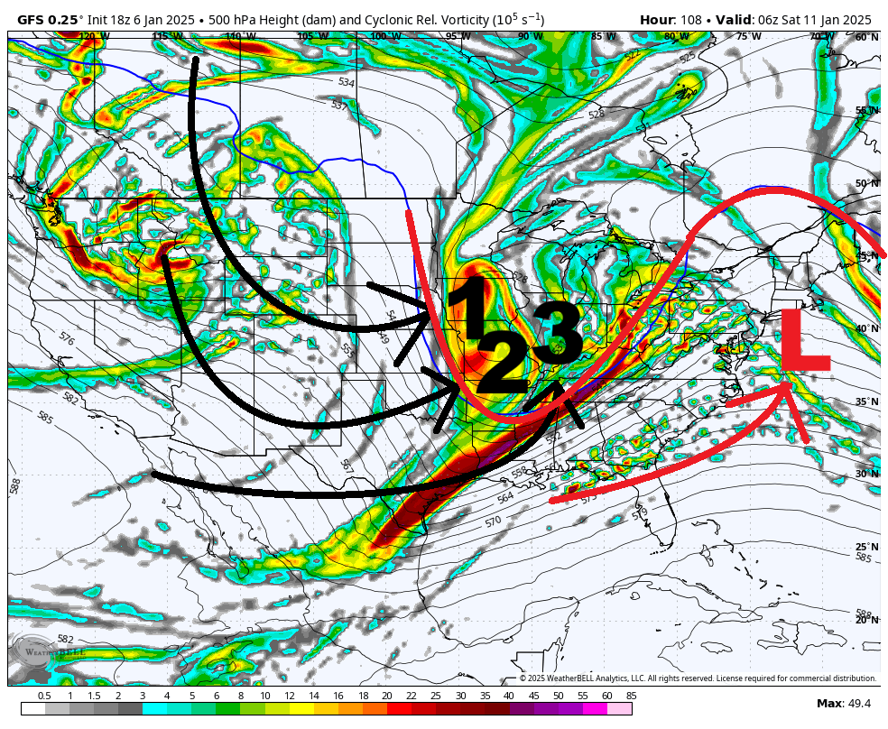
This next image of cyclonic vorticity that I want to show you is from yesterday’s 18Z GFS showing #1 and #2 phasing into #3 perfectly, creating more of a round concentric UL of vorticity over the N Pains/Great Lakes. This ultimately produces a more amplified meridional look needed to turn east coast geopotential heights higher and dig the system better in the C US. This is the upper energy look you want for the surface storm low to track favorably for a major NJ snowstorm:

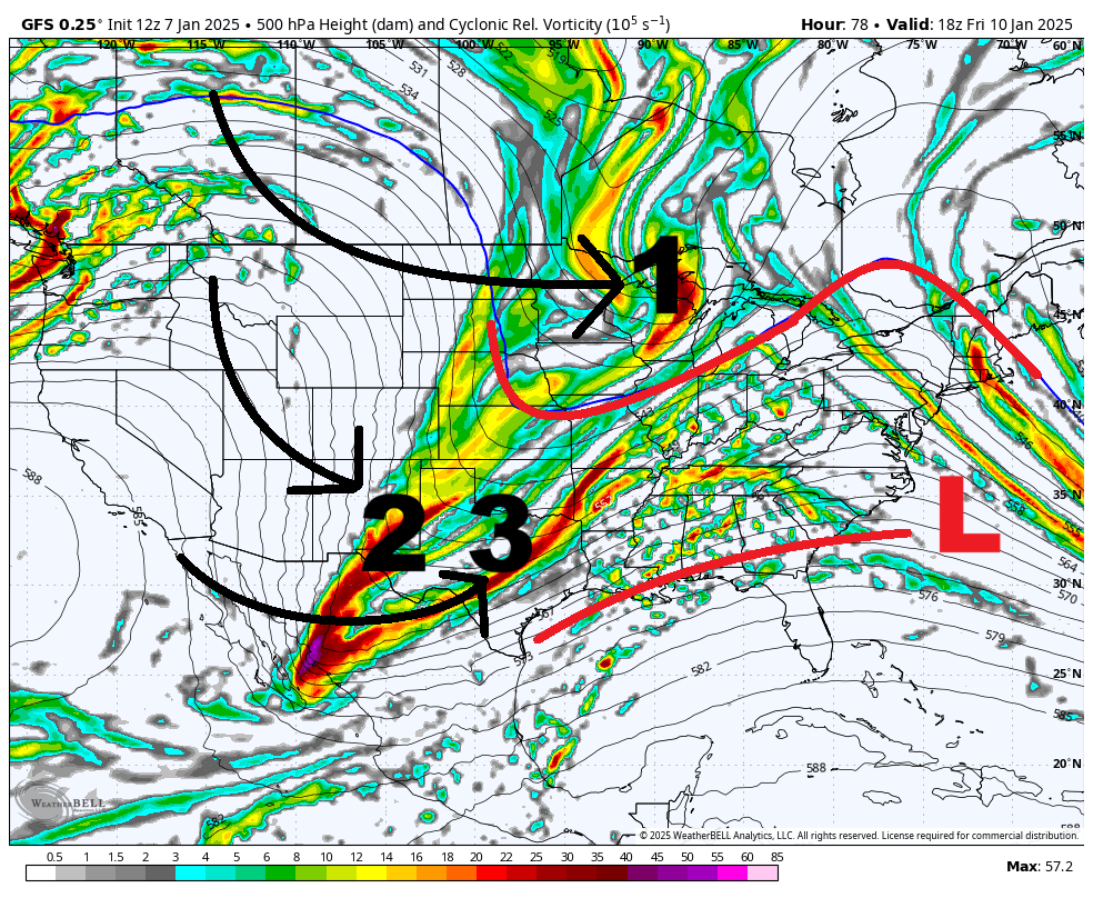
Yesterday’s 18Z GFS was the last model run to show the major NJ snowstorm. What has happened from yesterday to today, on most model guidance is that #1 is not phasing into the system. Instead, #1 stays N and acts as a suppressor of heights as it drifts E across the N US/S Canadian border. #2 and #3 still phase but that only produces a mediocre/significant snowstorm (3-6/4-8 inches) for NJ rather than the major snowstorm of 12-18+ inches. Instead you get a snow swath produced by partial interaction/partial phase rather than a fully wrapped-up and phased solution. And depending on that interaction, you have anything from just N stream snow showers only to a 3-6/4-8 inch snowstorm with the N and S streams only partially interacting. This next image depicts this and represents all model guidance so far today, mainly the GFS, Euro and Canadian global operational models:

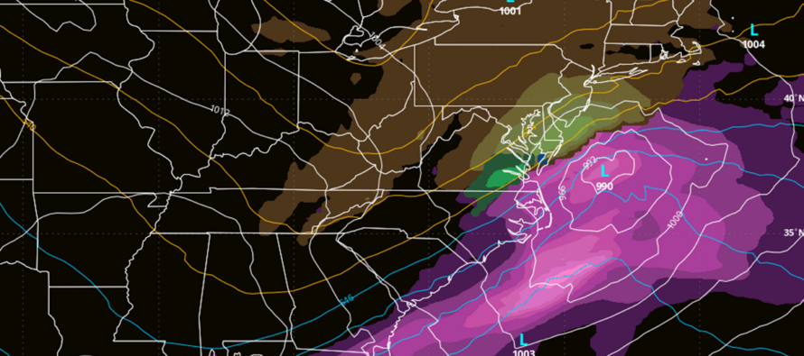
Today, we are just 4 days away from this snow event however we are arriving at a consensus IMO. Could the major full phase solution still happen? Sure but I would assign lower probability to that. Instead I would assign higher probability on anything from just snow showers to just a significant snowstorm capable of producing plowable snow across the region again. A full phased solution would cripple the I-95 corridor and points NW with snowfall while likely introducing mixing issues that would keep snow totals down SE of I-95. The more realistic solution has actually been targeting the I-95 corridor and points SE of such with significant snowfall. Our first official snow map and forecast wouldn’t come until Thursday. The next two days, we’ll be monitoring the upper-levels for a consensus on phasing. This is where I’m at right now. The top cover image represents the snowfall produced from today’s less-impressed solutions.
Beyond this weekend, there are a few more storm signals in the Jan 16-20 period before we finally take a break from the colder wintry pattern in the last third of January. A lot of winter left.
In English: Expect cold, dry, and gusty wind conditions today through Friday morning. Much of NJ will remain below freezing. Only SNJ/SENJ might break freezing each day with the rest of NJ below 32 even for daytime highs. On Friday, winds likely subside, and we should experience a warmer day (if you call highs in the mid-30s warmer). Temps then fall again Friday night into the 20s for most of NJ and we anticipate another snow event either just Saturday or possibly Saturday into some of Sunday morning. Model guidance is currently leaning away from a massive snowstorm and rather towards another light-to-significant snowstorm. A major snowstorm has a non-zero probability but seems low for now. There are a lot of variables that need to be considered over the next 48 hours or so before we begin snow maps and detailed forecasts on Thursday. Serious tracking and model analysis until then. The public will get a daily article summarizing my thoughts. Premium subscribers will get to see my thoughts in real-time from model suite to model suite ad-free and early. Have a great rest of your Tuesday and please be safe! JC
Premium Services
KABOOM Club offers ad-free content, inside info forecast discussion, your questions answered, and early storm impact maps and video releases (ahead of the public). At two bucks per month, it’s an extremely feasible way to show additional support for Weather NJ. Think of it as a tip jar with perks. Available onFacebook or Patreon.
My Pocket Meteorologist (MPM), in partnership with EPAWA Weather Consulting, offers professional/commercial interests, whose businesses depend on outdoor weather conditions (snow plowing, landscaping, construction, etc.), with hyper-local text message alerts/forecasts and access to the MPM premium forum—the most comprehensive and technical forecast discussion available for PA and NJ.
Jonathan Carr (JC) is the founder and sole operator of Weather NJ, New Jersey’s largest independent weather reporting agency. Since 2010, Jonathan has provided weather safety discussion and forecasting services for New Jersey and surrounding areas through the web and social media. Originally branded as Severe NJ Weather (before 2014), Weather NJ is proud to bring you accurate and responsible forecast discussion ahead of high-stakes weather scenarios that impact this great garden state of ours. All Weather. All New Jersey.™ Be safe! JC


