

Weekend Snow/Ice/Rain Storm Developing
Discussion: Before we get to wintry and non-wintry expectations for the weekend, let’s look at the forecast leading up to the event. We’ve been in daily article storm mode for a while now and it’s easy to lose focus on the regular weather between. Today has been a relatively mild day. Temps ranged from 40-50 N to S at their max point a little earlier this afternoon. A cold front will push through this evening along with some gusty NW winds. Peak wind intensity should last until around midnight tonight before subsiding some for the rest of overnight hours and relaxing by mid-to-late tomorrow (Friday) morning. Overnight lows tonight should range from about 18-28 N to S by the time we reach 7am tomorrow morning. Friday then looks clear and cold with highs ranging 32-38 N to S as NW winds continue to relax. Friday night then looks even colder with temps likely in the 15-25 range N to S by 7am Saturday morning.
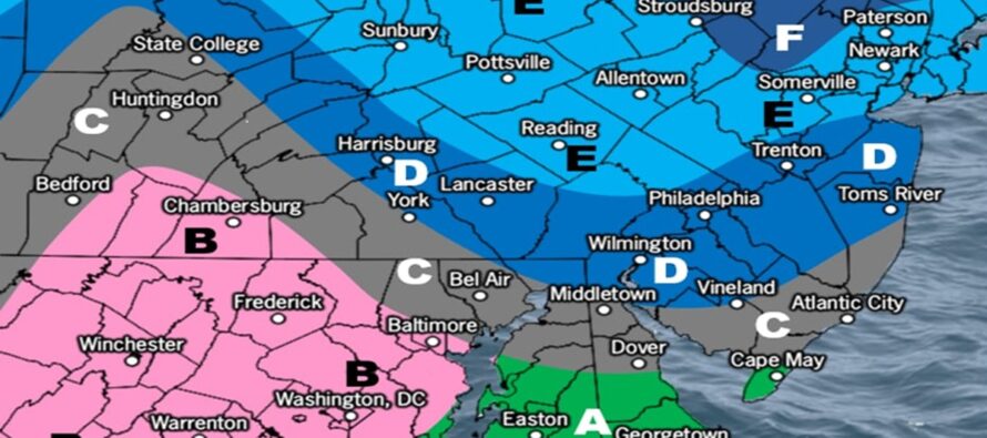
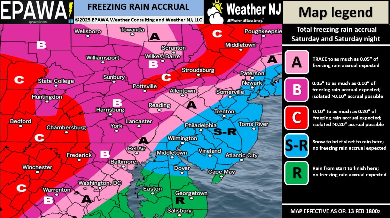
On Saturday morning, precipitation will approach from the W while the ground and air aloft is still cold. For this reason, we believe that much of NJ will start out with a snowy burst before noon. Warm air will then advect into NJ and drive temperatures above freezing from SNJ to NNJ. SNJ will be first to rise above freezing, likely by noon. CNJ will be slower to rise above freezing and NNJ will be last to rise above freezing. This means that even though a lot of NJ will see a snowy start Saturday late-morning, only NNJ and some of CNJ have the chance to accumulate anything significant before the changeovers push S to N. Below are two maps, one for front-end snow and the other for freezing rain during the transition from snow to rain.
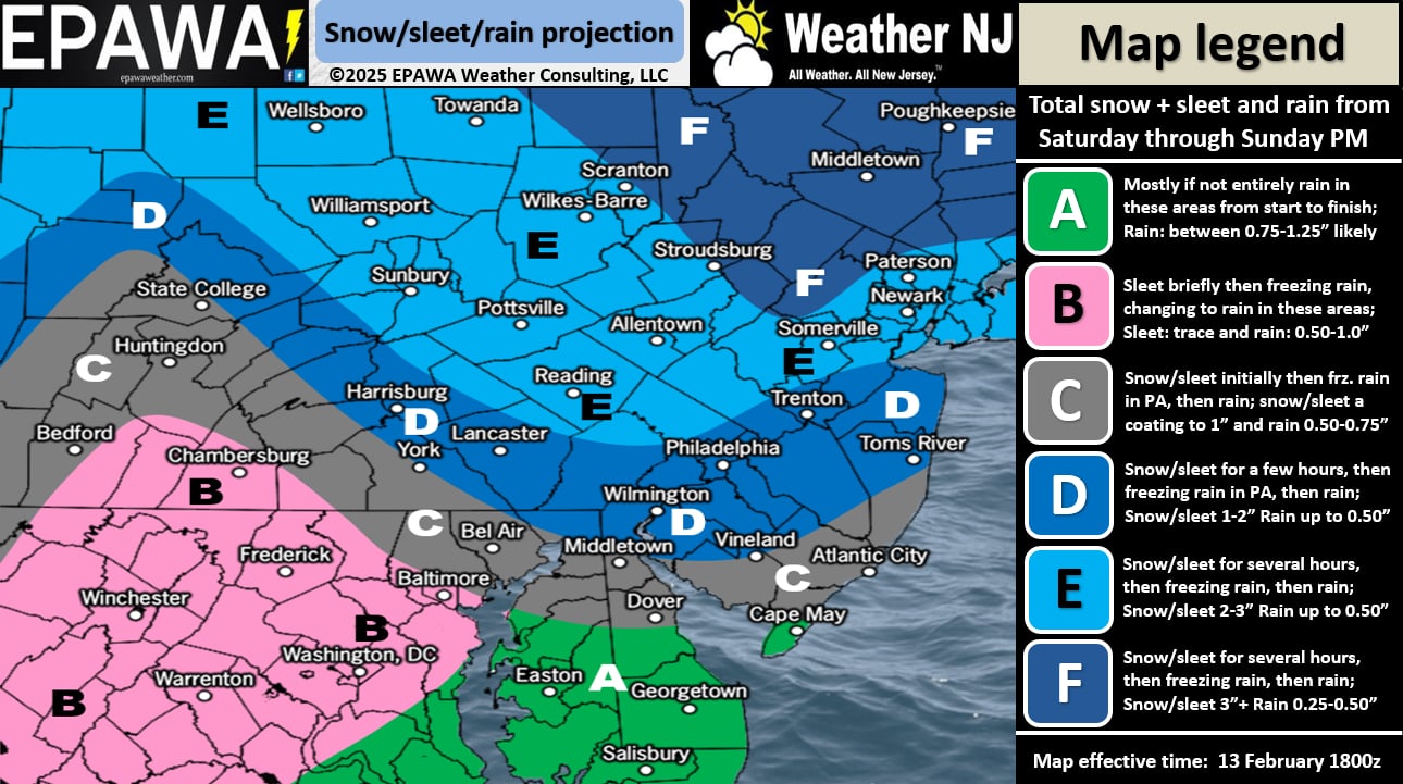
The snow amounts that fall S of I-195 will likely be insignificant as warmer temps and rain will melt anything that accumulates. It’s really along and N of I-78 that has the best chance to accumulate snow. NENJ should see a little less accumulation than NWNJ due to NYC proximity. So if NWNJ tops out in the 2-3” range, I would expect NENJ to be more in the 1-2” range. You get the idea.
Once everything goes over to rain, likely by midnight Saturday night, it will rain into Sunday morning. A lull is possible between mid-to-late Sunday morning and Sunday afternoon/early evening. Rain should then return, possibly heavy at times, for Sunday night into Monday. Another cold front then rips through Monday, keeping it cold into the Wed-Fri snowstorm signal which is very much still alive. I’ll be diving into serious tracking mode on Sunday if still supported this much on model guidance and upstream observations in the E Pacific Ocean.
In English: It’s going to get cold and windy tonight (Thursday night). Tomorrow should feel like a cold and clear day followed by an even colder Friday night into Saturday morning. Snow then moves in by late-Saturday morning, changes to sleet and/or freezing rain between Saturday afternoon and evening, then changes to rain by midnight Saturday night. Expect rain through Sunday morning, a break midday, and then rain returns Sunday night into Monday. On Monday it will get cold again and stay cold into the snowstorm signal next Wednesday-Friday. More to come. For now, all focus on this weekend’s snow-to-ice-to-rain event. Have a great rest of your Thursday and please be safe! JC
Premium Services
KABOOM Club offers ad-free content, inside info forecast discussion, your questions answered, and early storm impact maps and video releases (ahead of the public). At two bucks per month, it’s an extremely feasible way to show additional support for Weather NJ. Think of it as a tip jar with perks. Available onFacebook or Patreon.
My Pocket Meteorologist (MPM), in partnership with EPAWA Weather Consulting, offers professional/commercial interests, whose businesses depend on outdoor weather conditions (snow plowing, landscaping, construction, etc.), with hyper-local text message alerts/forecasts and access to the MPM premium forum—the most comprehensive and technical forecast discussion available for PA and NJ.
Jonathan Carr (JC) is the founder and sole operator of Weather NJ, New Jersey’s largest independent weather reporting agency. Since 2010, Jonathan has provided weather safety discussion and forecasting services for New Jersey and surrounding areas through the web and social media. Originally branded as Severe NJ Weather (before 2014), Weather NJ is proud to bring you accurate and responsible forecast discussion ahead of high-stakes weather scenarios that impact this great garden state of ours. All Weather. All New Jersey.™ Be safe! JC


LOCAL FORECAST | INTERACTIVE RADAR | LATEST NJ WEATHER ALERTS | WEDDING FORECAST| PRIVACY POLICY
© Copyright 2025 Weather NJ LLC. All Rights Reserved.
Some information that can be found on our website is provided by a private weather station and is not an officially recognized station for weather reporting. Though we always strive to achieve accurate reporting for our own use, it is important that you do NOT depend on the data provided here for any purpose.
