

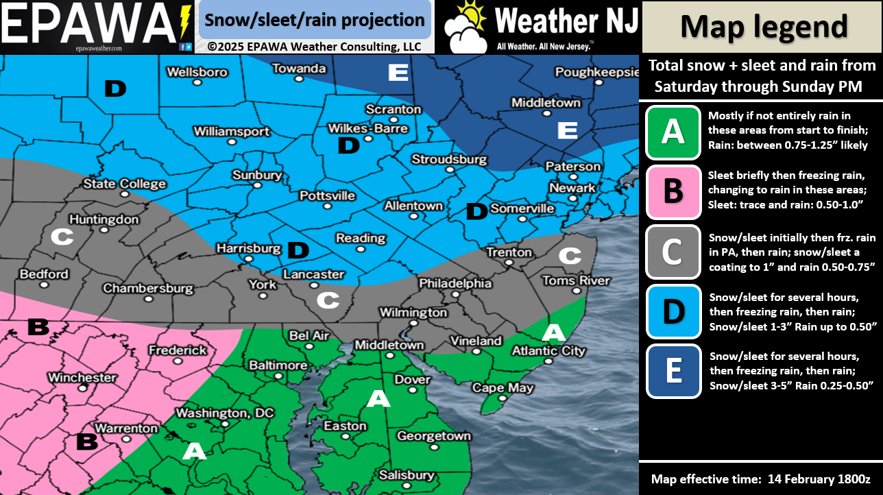
Discussion: A weak low will ride the thermal boundary and drive into W PA from the TN area tomorrow (Saturday). Initial precipitation will crash into a wall of cold air at first and generate a front-end snowfall for most of NJ with NNJ seeing light-to-significant snow accumulations between Saturday late-morning/early-afternoon and Saturday evening. Snow should then turn to some ice first then plain rain from S to N Saturday evening into early Sunday morning. Then rain is expected between Sunday morning and early Monday morning with a lull expected midday Sunday. Expect Sunday to feel freakishly warm from the synoptic driven warmth once the cold air pushes offshore and the low transfers to a secondary coastal. At that point, NJ will be in a warm sector and breaking 60 degrees in SNJ is not off the table. The following two maps represent how much snow accumulation and ice accrual we expect between about noon Saturday and Saturday evening before going to all rain. We’ve made a few updates from yesterday after reviewing 24 hours of more data and live observations upstream. Rainfall amounts are then expected to be in the 2-3+ range when all is said and done which is much needed for our grounds.

Arctic cold air then returns Monday and sets a cold stage for the Wed-Thurs (Feb 19-20) storm signal. Models are still going wild. GFS a little SE today. Canadian a little NW. Euro a direct hit. Don’t live and die by your specific weather app output. For now (until Sunday night), I’m just tracking a solid snowstorm signal, capable of producing a major snowstorm, run to run. If still supported Sunday night/Monday morning, it will be time to start preparing for a possible KABOOM snowstorm. Patience until then!
In English: Not much has changed for Saturday into Sunday. Another snow-to-ice-to-rain situation ending late Sunday night/early Monday morning. Very warm Sunday! Very cold Monday as Arctic air crashes back in and sets the stage for a possible major snowstorm Wednesday into Thursday. I’ll be providing run-by-run model analysis for premium subscribers. Have a great weekend and please be safe! JC
Premium Services
KABOOM Club offers ad-free content, inside info forecast discussion, your questions answered, and early storm impact maps and video releases (ahead of the public). At two bucks per month, it’s an extremely feasible way to show additional support for Weather NJ. Think of it as a tip jar with perks. Available onFacebook or Patreon.
My Pocket Meteorologist (MPM), in partnership with EPAWA Weather Consulting, offers professional/commercial interests, whose businesses depend on outdoor weather conditions (snow plowing, landscaping, construction, etc.), with hyper-local text message alerts/forecasts and access to the MPM premium forum—the most comprehensive and technical forecast discussion available for PA and NJ.


Jonathan Carr (JC) is the founder and sole operator of Weather NJ, New Jersey’s largest independent weather reporting agency. Since 2010, Jonathan has provided weather safety discussion and forecasting services for New Jersey and surrounding areas through the web and social media. Originally branded as Severe NJ Weather (before 2014), Weather NJ is proud to bring you accurate and responsible forecast discussion ahead of high-stakes weather scenarios that impact this great garden state of ours. All Weather. All New Jersey.™ Be safe! JC