Discussion: There’s three things I’d like to talk about:
Tonight: Rain and thunderstorms will continue to push southward through the rest of NJ this evening. I expect them to clear the tip of SNJ by ~10pm. There’s an area of high pressure pushing everything to the S so once the cold front is through (from N to S) the southern side of the high’s anticyclonic winds will begin producing onshore flow.
This Weekend: The strong sea breeze front that formed on Thursday sort of jump-started the onshore flow that should persist through most of Friday. It appears we have a warm front that will form on the departing high’s return flow for Saturday. We also have another cold front approaching from the W (later Saturday PM) on the front of another high. This makes the weekend a very hard call temperature-wise. Upper-level ridging should dominate the pattern. I could see NWNJ behaving differently than SENJ. Drier and cooler for NWNJ. Warmer and more humid for SENJ. Some showers and thunderstorms could be around on Saturday but Sunday looks pretty dry. We should then return to warmer temperatures for everyone to at least start next week.
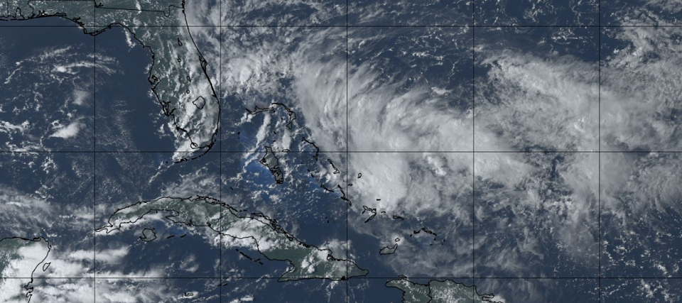
The Tropics: Tropical Cyclone 9 has formed in the Bahamas. This storm will be named Humberto if it can reach/meet tropical storm criteria. There is a lot of disagreement between the GFS and Euro models regarding this system. The GFS is actually alone with its weaker solution across southern Florida towards the Gulf of Mexico. Most other models take tropical cyclone 9 a little further N towards central/northern Florida. The Euro is getting quite interesting beyond that. By this Sunday morning the Euro has tropical cyclone 9 (likely Humberto) just off the Florida coast (E of Cape Canaveral). There is a ridge modeled to the N of the system over the Mid-Atlantic US. As the ridge slips further out to sea to the SE its anticyclonic steering currents on the W side could turn Humberto up the east coast. The Euro then suggests another ridge moving in later in the week which Humberto would likely tuck under and head towards the coastal Mid-Atlantic US area. I’m really hoping the Euro is wrong but this is the second model run in a row that has turned my head. If the Euro were to verify then Humberto could be getting pretty close to the NJ coast in the ~Friday period. I’m going to watch tropical cyclone 9 evolve as it moves towards Florida through this weekend. Weak and W is what we want to see. Strong and N is what we do not want to see. I’ll be paying specific attention to the intensity development of tropical cyclone 9 and how the ridge to its N behaves. That’s about all you can do for now with such spread in the models (uncertainty).
Friday (Sept 13) high temperatures should only reach into the low-70s statewide. Skies should transition from mostly cloudy to partly cloudy throughout the day. Light rain is possible especially during morning/early-afternoon hours. Winds should be light out of the ENE breezier near the coast. Overnight lows should range from lower-50s to lower-60s NNJ to SNJ.
Saturday (Sept 14) high temperatures should reach the mid-to-upper 70s for most areas. Skies should be mixed with sun and clouds with a few showers and thunderstorms around. Winds should transition from SE to SW. Overnight lows should range from near-60 to near-70 NNJ to SNJ.
Sunday (Sept 15) high temperatures should vary from NNJ to SNJ. NNJ is more likely to see a lower humidity not as hot day. SNJ is more likely to see warmer and more humid conditions. Looks like 70s for NNJ and lower-80s for SNJ. NJ should stay dry.Winds should be light out of the W during the day but transition to NW. Overnight lows should range from upper-50s to upper-60s NNJ to SNJ.
An early look at next week indicates fairly average conditions with highs in the 70s/low-80s. The start of the week might lean a little warmer than the end of the week. I am monitoring the tropics very closely and will report accordingly for the period heading into next weekend. Please see the above tropics discussion for what I am referring to.
Download the new free Weather NJ mobile app on Apple and/or Android. It’s the easiest way to never miss Weather NJ content. Our premium services go even further above and beyond at the hyper-local level. Looking for industrial-caliber long-range forecasting data that I personally recommend? Check out WeatherTrends360!
Jonathan Carr (JC) is the founder and sole operator of Weather NJ, New Jersey’s largest independent weather reporting agency. Since 2010, Jonathan has provided weather safety discussion and forecasting services for New Jersey and surrounding areas through the web and social media. Originally branded as Severe NJ Weather (before 2014), Weather NJ is proud to bring you accurate and responsible forecast discussion ahead of high-stakes weather scenarios that impact this great garden state of ours. All Weather. All New Jersey.™ Be safe! JC
