

Tropical Remnants Detected!
Discussion: The Canadian trough that pushed the frontal boundary over NJ from N to S is now clearing away to the E into the N Atlantic Ocean. The frontal boundary is currently (as of noon Wednesday) draped across Cape May, Cumberland, and S Atlantic Counties which has been delivering showers with a few rumbles since about dawn today (Wednesday). The boundary started across NNJ/CNJ last night and brought inches of rainfall and severe-warned thunderstorms to many in NNJ/CNJ. SNJ will no doubt see less rain from this frontal boundary event with many not seeing much at all across Burlington and Ocean Counties.
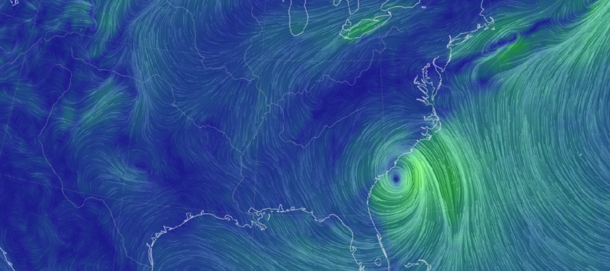
A ridge will now build along the Mid-Atlantic/Northeast US and temporarily trap Debby from northward movement up the coast until about Thursday PM. Debby is currently a tropical storm off the coast of South Carolina with a central low pressure of around 995mb. At some point between tonight (Wednesday) and tomorrow morning (Thursday), Debby will transition from a tropical storm to a post-tropical depression as it begins it’s track northward into the interior Mid-Atlantic US. This will reverse the frontal boundary’s southward movement back to a northward movement as a warm front. NJ will then see outer rain band impact starting Thursday and gradually increasing through Friday as Debby tracks W of NJ.
The Euro picked up the more westward track yesterday morning and the rest of model guidance has followed suit. The reason for this is because the next trough is slightly delayed. The front of this next trough contains the steering currents to ultimately re-curve Debby’s remnants back to the E and up into the N Atlantic Ocean. If the trough was earlier as modeled in prior days, Debby would have passed over NJ or slightly offshore. But now that the expectation is a later trough, Debby will be allowed to slide well into PA, to the W of NJ. So, what does this mean for NJ?
NJ will still see a good amount of much-needed rainfall from intermittent outer rain bands…at least 1-3 inches between Thursday and Friday in addition to everything that fell last night and this morning. The highest rainfall totals will likely be over PA and NWNJ elevations, partly from orographic influence (lifting generated from mountains) but mainly from the low track. Just keep in mind that tropical rainfall is a very fine water droplet and is more of a warm drenching (wind-whipped) rainfall rather than larger colder drops. Therefore, rainfall totals will be achieved from a prolonged period of tropical rain (Thursday through Saturday morning), not from short spurts.
NJ might see some of the moderate winds make their way inland rather than staying along the immediate coast. We’re not talking destructive widespread winds, more like a traditional coastal storm or weak nor’easter. Felt most along the coast but noticeable inland and up in elevations. Again, that’s at the widespread level. A small wildcard needs to be mentioned about tornadoes. NJ will be in the NE quadrant of Debby for a little of Thursday night and Friday. This is typically where tornadoes form when a tropical system gets over land. However, we will have a decaying post-tropical depression, not a wrapped up and organized cyclone. So, the threat is lessened but not non-zero for a few EF0/EF1 (weaker) tornadoes to form.
Coastal regions of SNJ/SENJ/ECNJ will likely have the additional hazards of coastal flooding, beach erosion, dangerous rip currents, and enhanced surf. ECNJ and SENJ coasts will see an onshore flow develop out of the E starting Thursday morning. This flow will slowly change to SE by Friday morning and then to S by Friday night/Saturday morning. That’s a 48-hour period (4 high tides) where you can expect at least minor coastal flooding (water in the streets for people who normally see water in the streets). Rainfall will have nowhere to drain in these areas which could lead to additional flooding factors. Whether or not coastal flooding crosses from minor into moderate stage is yet TBD. But at least minor coastal flooding is a reasonable expectation.
Debby’s remnants look to clear out of New Jersey earlier than later on Saturday. This should allow for ideal weekend conditions most of Saturday and all of Sunday. When a tropical system pushes through and introduces a trough like this, the air that follows is usually miraculous feeling. Dew point temperatures should dive into the 50s with dry W/NW or NW flow. It’s going to feel amazing this Saturday and Sunday. So, we have that to look forward to once we get through all of Debby’s impacts by early Saturday morning.
In English: Today we have a little break in the rain outside of extreme SNJ and a few isolated showers moving through. A more concentrated rain should then push into NJ from the S starting Thursday as outer bands on Debby’s N side push in from the S. Rainfall should gradually build from Thursday into Friday before ending early Saturday morning. A few inches of rainfall are possible statewide when all is said and done with NWNJ favored over SENJ for jackpot rainfall totals. Winds should also start to form statewide off the ocean Thursday and peak Friday…moderate winds not destructive and felt most along the coast. Power outages still possible from duration of winds not so much speed of winds. Power outages should be isolated not widespread. So, the most reasonable expectation of impacts are periods of moderate rainfall, moderate winds, and minor coastal flooding between Thursday (includes all of Friday) and early Saturday morning. A less probable set of expectations (but non-zero chance) are periods of heavy rainfall, isolated weak tornadoes, and moderate coastal flooding. At this point I am leaning more towards the reasonable set of expectations. It all clears out early Saturday morning—allowing gorgeous low humidity conditions to move in for most of Saturday and all of Sunday. We’re talking high temps in the low-80s with dews in the 50s…the stuff you’d like to bottle and sell mid-winter or mid-heat wave. And these great conditions should spill into at least early next week. I’ll update tomorrow when Debby’s remnants are approaching. Have a great rest of your Wednesday and please be safe! JC
Premium Services
KABOOM Club offers inside info forecast discussion, your questions answered, and early storm impact maps (ahead of the public). At a buck per month, it’s an extremely feasible way to show support.
My Pocket Meteorologist (MPM), in partnership with EPAWA Weather Consulting, offers professional/commercial interests, whose businesses depend on outdoor weather conditions (snow plowing, landscaping, construction, etc.), with hyper-local text message alerts/forecasts and access to the MPM premium forum—the most comprehensive and technical forecast discussion available for PA and NJ.
Jonathan Carr (JC) is the founder and sole operator of Weather NJ, New Jersey’s largest independent weather reporting agency. Since 2010, Jonathan has provided weather safety discussion and forecasting services for New Jersey and surrounding areas through the web and social media. Originally branded as Severe NJ Weather (before 2014), Weather NJ is proud to bring you accurate and responsible forecast discussion ahead of high-stakes weather scenarios that impact this great garden state of ours. All Weather. All New Jersey.™ Be safe! JC


LOCAL FORECAST | INTERACTIVE RADAR | LATEST NJ WEATHER ALERTS | WEDDING FORECAST| PRIVACY POLICY
© Copyright 2025 Weather NJ LLC. All Rights Reserved.
Some information that can be found on our website is provided by a private weather station and is not an officially recognized station for weather reporting. Though we always strive to achieve accurate reporting for our own use, it is important that you do NOT depend on the data provided here for any purpose.
