

Thunderstorms Tonight!
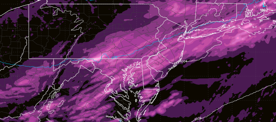
Discussion: Well, we’re baking again today (Wednesday) and another cold front is approaching tonight that will bring relief from heat and humidity for Thursday and Friday. The current expectation for tonight are downpours and thunderstorms to ride the cold front through between later tonight and tomorrow morning.
Tonight’s storms are arriving late, likely around or after sundown which, as we know, is late this time of year. Also, it doesn’t look like a singular linear hit. I’m seeing broken, isolated, and independent thunderstorm cells arriving out ahead of the main stormfront cold front line. These isolated cells ahead are the ones most capable of producing isolated tornadoes. Tornadoes are no the primary threat tonight but certainly a non-zero chance. The rest of tonight’s thunderstorm threat would then be just ahead of the linear front.
The most realistic prediction for tonight are showers, downpours, and frequent lightning. The slightly-less probable outcome are wind gusts exceeding 60mph and hail. The least probable outcome are isolated tornadoes but again, a non-zero chance.
We have ridonkulous instability in place. SW flow has brought a very hot and humid airmass to NJ and this is producing negative buoyancy (air can rise easier with a lifting trigger) via adequate diurnal surface heating. The lifting trigger is a low and cold front which should generate adequate vertical wind shear to produce strong-to-severe thunderstorms. The last storms should push through NJ by sunrise Thursday morning, if not slightly earlier.
The weekend forecast has taken a turn for the worse with another slow-moving frontal passage with possible coastal enhancement. It looks like rain and storms at least Saturday evening through much of Sunday. I will revisit this in a few days.
In English: More thunderstorms are possible tonight. They should only approach WNJ around 8pm (ENJ by 10pm-ish) and take until ~4am to fully push through all of NJ. NOT EVERYONE IS GAURANTEED TO GET HIT. Just know that there’s a good general chance for it. High confidence that storms will contain heavy downpours and frequent lightning. Medium confidence in severe wind gusts and hail. Lower confidence (but non-zero chance) of isolated tornadoes. Gorgeous weather awaits behind these storms for Thursday-Friday. Saturday and Sunday looking rainy/stormy with maybe Saturday ok until afternoon/evening hours. Have a great night and please be safe! JC
Premium Services
KABOOM Club offers inside info forecast discussion, your questions answered, and early storm impact maps (ahead of the public). At a buck per month, it’s an extremely feasible way to show support.
My Pocket Meteorologist (MPM), in partnership with EPAWA Weather Consulting, offers professional/commercial interests, whose businesses depend on outdoor weather conditions (snow plowing, landscaping, construction, etc.), with hyper-local text message alerts/forecasts and access to the MPM premium forum—the most comprehensive and technical forecast discussion available for PA and NJ.
Jonathan Carr (JC) is the founder and sole operator of Weather NJ, New Jersey’s largest independent weather reporting agency. Since 2010, Jonathan has provided weather safety discussion and forecasting services for New Jersey and surrounding areas through the web and social media. Originally branded as Severe NJ Weather (before 2014), Weather NJ is proud to bring you accurate and responsible forecast discussion ahead of high-stakes weather scenarios that impact this great garden state of ours. All Weather. All New Jersey.™ Be safe! JC


LOCAL FORECAST | INTERACTIVE RADAR | LATEST NJ WEATHER ALERTS | WEDDING FORECAST| PRIVACY POLICY
© Copyright 2025 Weather NJ LLC. All Rights Reserved.
Some information that can be found on our website is provided by a private weather station and is not an officially recognized station for weather reporting. Though we always strive to achieve accurate reporting for our own use, it is important that you do NOT depend on the data provided here for any purpose.
