

Thunderstorm Front Detected
Discussion: In a surprise to no one, it’s starting to get hot out. The first day of calendar summer approaches along with the summer solstice. We finally turned the corner into a summer-like ridge pattern and that looks to dominate the rest of June with above-average temperature anomalies. There’s one disruption however this weekend as a small and transient trough swings through the sea of above-average geopotential height anomalies currently resting over our region. On the front of that trough is going to be a frontal boundary in the lower-levels that will push through NJ from NW to SE between Friday PM and early Saturday AM.
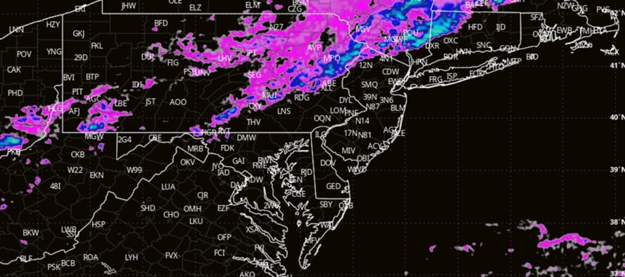
I expect this frontal boundary to kick up severe storms for New England and parts of the Mid-Atlantic US, including parts of NJ. There’s going to be a coastal low off the S Mid-Atlantic US that will throw a wrench in. The low and its immediate surroundings will feature lifting off the S Mid-Atlantic US. The frontal boundary itself will feature lifting as it pushes from the Great Lakes through NJ. The wrench will be the sinking air (suibsidence) between the low and the frontal boundary. This is why I think much of SENJ will see weaker storms…they will be robbed of the better dynamics and lifting. This is also why I believe that at least NWNJ, possibly points just SE down to I-95, will see the most severe storms Friday night. The frontal boundary will be plowing into a soupy air mass tomorrow as much of NJ likely reaches 85+ degrees on Friday with dew points in the 65-70 range. Adequate diurnal instability and adequate vertical wind shear/lifting from the front itself.
So, with that said, I expect the frontal boundary to push through NJ, again NW to SE, Friday PM into early Saturday AM. I expect rain to train along this boundary from SW to NE. So when you look on radar later tomorrow, the rain cells will likely move quickly from SW to NE as the frontal boundary (and overall frontal system) moves slowly from NW to SE.
In English: Friday should reach well into the 80s with some spots flirting with 90. The day should start sunny and humid but eventually a storm front will likely push through your area. It’s hard to gauge timing because the front will be moving slow and from a non-typical axis (NW to SE). But the storms look to start as early as afternoon for NWNJ and finish as late as nighttime for SENJ (would mean a late-afternoon/early evening passage through most of CNJ). NWNJ should see the most intense storms (downpours, lightning frequency, wind gusts, etc). The storms are expected to weaken as they push SE through the rest of NJ. The I-95 corridor should expect severe storms to become non-severe over them. And then SENJ, especially the SENJ coast should expect storms to weaken to non-severe status by the time they push through last at the end of the night. This should then set up a nicer drier feeling weekend…temps still warm but lower humidity under high pressure. Then we’re back to heat and humidity for next week and likely through the rest of June. Have a great rest of your Thursday and please be safe! JC
Premium Services
KABOOM Club offers inside info forecast discussion, your questions answered, and early storm impact maps (ahead of the public). At a buck per month, it’s an extremely feasible way to show support.
My Pocket Meteorologist (MPM), in partnership with EPAWA Weather Consulting, offers professional/commercial interests, whose businesses depend on outdoor weather conditions (snow plowing, landscaping, construction, etc.), with hyper-local text message alerts/forecasts and access to the MPM premium forum—the most comprehensive and technical forecast discussion available for PA and NJ.
Jonathan Carr (JC) is the founder and sole operator of Weather NJ, New Jersey’s largest independent weather reporting agency. Since 2010, Jonathan has provided weather safety discussion and forecasting services for New Jersey and surrounding areas through the web and social media. Originally branded as Severe NJ Weather (before 2014), Weather NJ is proud to bring you accurate and responsible forecast discussion ahead of high-stakes weather scenarios that impact this great garden state of ours. All Weather. All New Jersey.™ Be safe! JC


LOCAL FORECAST | INTERACTIVE RADAR | LATEST NJ WEATHER ALERTS | WEDDING FORECAST| PRIVACY POLICY
© Copyright 2026 Weather NJ LLC. All Rights Reserved.
Some information that can be found on our website is provided by a private weather station and is not an officially recognized station for weather reporting. Though we always strive to achieve accurate reporting for our own use, it is important that you do NOT depend on the data provided here for any purpose.
