

Stormy Monday Night Expected
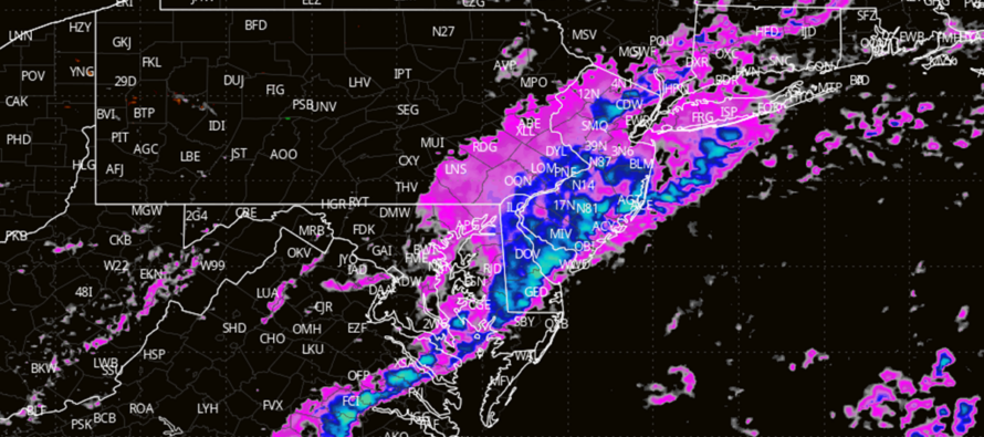
Discussion: Temperatures should moderate back into the 65-75 range tomorrow (Monday) as a warm sector influences NJ with warmer temperatures and higher levels of humidity. A stormfront is then expected to pass through New Jersey from NW to SE between about 7pm and midnight Monday night. So much of the day will be dry and mild despite a breezy-to-gusty wind situation out of the S/SW.
Regarding the intensity of the stormfront, at least downpours and breezy-gusty winds are expected with high confidence. Lightning is very likely but not guaranteed for all NJ locations as the stormfront will be passing through NJ after sundown (loss of diurnal instability). With that said, NWNJ has the best chance for thunderstorm activity and SENJ has the least chance for thunderstorms. All are on the hook though. Lesser chance occurrences would be hail and or tornadoes. These are low chances but non-zero and will be called hyper-locally upon warnings.
A cold front then follows the stormfront and sets up a cooler Tuesday-Wednesday before temps rebound milder again for Thursday-Friday but under unsettled conditions (clouds, rain, possibly more thunderstorms). The weekend looks more settled but in-between temperature-wise (highs in the 55-65 range).
In English: Expect a mild breezy day on Monday with rain and thunderstorms likely pushing through from NW to SE between 7pm and midnight. Downpours and breeze are good bets. Low but non-zero chances for hail and isolated tornadoes. This sets up a cooler dryer Tues-Wed then a warmer and wetter Thurs-Friday. I’ll get a weekly outlook out after tomorrow night’s stormfront. Be safe! JC
Premium Services
KABOOM Club offers ad-free content, inside info forecast discussion, your questions answered, and early storm impact maps and video releases (ahead of the public). At $1.99 per month, it’s an extremely feasible way to show additional support for Weather NJ and you can can turn it on and off for however many months you wish. Think of it as a tip jar with perks. The public eventually sees all info discussed in premium areas. Available onFacebook or Patreon.
My Pocket Meteorologist (MPM), in partnership with EPAWA Weather Consulting, offers professional/commercial interests, whose businesses depend on outdoor weather conditions (snow plowing, landscaping, construction, etc.), with hyper-local text message alerts/forecasts and access to the MPM premium forum—the most comprehensive and technical forecast discussion available for PA and NJ.
Jonathan Carr (JC) is the founder and sole operator of Weather NJ, New Jersey’s largest independent weather reporting agency. Since 2010, Jonathan has provided weather safety discussion and forecasting services for New Jersey and surrounding areas through the web and social media. Originally branded as Severe NJ Weather (before 2014), Weather NJ is proud to bring you accurate and responsible forecast discussion ahead of high-stakes weather scenarios that impact this great garden state of ours. All Weather. All New Jersey.™ Be safe! JC


LOCAL FORECAST | INTERACTIVE RADAR | LATEST NJ WEATHER ALERTS | WEDDING FORECAST| PRIVACY POLICY
© Copyright 2025 Weather NJ LLC. All Rights Reserved.
Some information that can be found on our website is provided by a private weather station and is not an officially recognized station for weather reporting. Though we always strive to achieve accurate reporting for our own use, it is important that you do NOT depend on the data provided here for any purpose.
