

Stormfront Approaching
Discussion: A potent upper low has crawled across the US from W to E over the last few days…very dynamic with lots of vorticity and clashing air masses of varying temperature/moisture. At the lower levels, this has created quite the stormfront that you might have heard about in the news over the last 48-72 hours, especially the N gulf states.
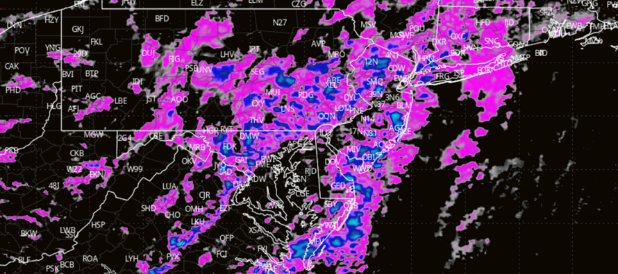
The stormfront is now approaching New Jersey with impacts expected later this evening. The stormfront will not be as potent as it was for areas like Mississippi and Alabama yesterday/overnight. Instead, NJ is going to see more of a remnant stormfront rather than a fully charged one…but it should still bring significant impacts.
We’re (NJ) still on the hook for rain downpours and gusty winds, however issues like hail and tornadoes should be less probable. We’ve lost the craziest dynamics and the remnant stormfront will be pushing through NJ after loss of diurnal surface heating (after sundown).
After reviewing the latest short-range model guidance and live observations, it is evident that the stormfront is moving very slowly and it is hard to pin the exact hour that it will affect NJ. The best timing anticipation I can do is as follows: Knocks on WNJ’s door around 5-7pm this evening, pushes across NJ between 7pm and 10pm, and then clears away from ENJ after midnight tonight. Not seeing a shark temp crash after the cold front. It will certainly become drier and cooler behind the cold front but this week should still open up with mild conditions.
In English: Expect S winds to continue building into this evening. Periods of moderate-to-heavy downpour should push into WNJ by 7pm, fill in through the rest of NJ from W to E between 7-10pm, and then exit ENJ after midnight. Rain and wind are all but guaranteed. Lightning, hail, and isolated tornadoes have a small non-zero chance on a localized/isolated basis. The most reasonable and realistic expectation is just a rainy/windy Sunday night with improvement for Monday and mild conditions building back to start the week. I’ll provide some radar obs updates this evening and get the weekly outlook out tomorrow once the rain and clouds clear by mid-morning. Have a great rest of your Sunday night and please be safe! JC
Premium Services
KABOOM Club offers ad-free content, inside info forecast discussion, your questions answered, and early storm impact maps and video releases (ahead of the public). At $1.99 per month, it’s an extremely feasible way to show additional support for Weather NJ and you can can turn it on and off for however many months you wish. Think of it as a tip jar with perks. The public eventually sees all info discussed in premium areas. Available onFacebook or Patreon.
My Pocket Meteorologist (MPM), in partnership with EPAWA Weather Consulting, offers professional/commercial interests, whose businesses depend on outdoor weather conditions (snow plowing, landscaping, construction, etc.), with hyper-local text message alerts/forecasts and access to the MPM premium forum—the most comprehensive and technical forecast discussion available for PA and NJ.
Jonathan Carr (JC) is the founder and sole operator of Weather NJ, New Jersey’s largest independent weather reporting agency. Since 2010, Jonathan has provided weather safety discussion and forecasting services for New Jersey and surrounding areas through the web and social media. Originally branded as Severe NJ Weather (before 2014), Weather NJ is proud to bring you accurate and responsible forecast discussion ahead of high-stakes weather scenarios that impact this great garden state of ours. All Weather. All New Jersey.™ Be safe! JC


LOCAL FORECAST | INTERACTIVE RADAR | LATEST NJ WEATHER ALERTS | WEDDING FORECAST| PRIVACY POLICY
© Copyright 2025 Weather NJ LLC. All Rights Reserved.
Some information that can be found on our website is provided by a private weather station and is not an officially recognized station for weather reporting. Though we always strive to achieve accurate reporting for our own use, it is important that you do NOT depend on the data provided here for any purpose.
