

Snowstorm to Likely Graze SENJ
Discussion: This storm has certainly juked a lot of us forecasters around. In full and honest transparency, if I haven’t already made it clear, uncertainty is high with this. We’re dealing with specific phase timing required + a possible InVerted Trough (IVT). It’s rare for us to not have an initial snow map out at least 48 hours before a snowfall but here we are.
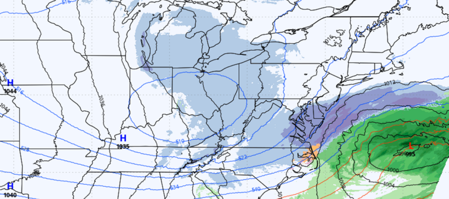
The lower-resolution 12km NAM stands by itself as far as bringing 6+ inches of snow all the way to I-95. We would need to see serious trends from other mesoscale models tonight/tomorrow morning for that to happen. The higher resolution 3km NAM however is a little more realistic with more of a graze. The 18z runs of both NAM versions were SE but indicated a lack of moisture that sometimes presents during 6z and 18z runs. The RGEM took steps more towards the wider-spread C-1/2 idea but came very close to IVT enhancement (lifting between the UL and coastal low) affecting ENJ. I’ll be looking at the 00Z suite tonight expecting to see a larger moisture signature. The position of the upper low and coastal low is what’s now contributing to even more uncertainty. If there’s an earlier phase, then more energy goes into the coastal and we’re left with most precipitation hugging the coastal low. If there’s a later or partial phase, then a bridge of lifting will exist over NJ and PA and the IVT will enter the chat. At the moment, the IVT idea drops a widespread C-1 maybe C-2 across most of NJ. But it would mean a miss out to sea for SENJ interests looking for the jackpot of the coastal low system.
So, in the case of an earlier complete phase and capture, SENJ would become much more plowable Tuesday morning and there would be a sharp cutoff likely SE of I-95 with little to no snow to the NW of I-95. If the partial phase happens, then most of NJ sees a C-1/2 scenario later Tuesday night. If the IVT comes to fruition than anyone along ENJ could see some enhanced snowfall. In weighing all of this together, the best I can produce at this point is an ideas map down the middle of the data road. The timing for this has pushed right a little…no longer a Wednesday PM into Thursday AM event…now more of a Thursday AM to Thursday PM event. This allows more time for trending, analysis and forecast adjustment. For now, this is where I’m at:
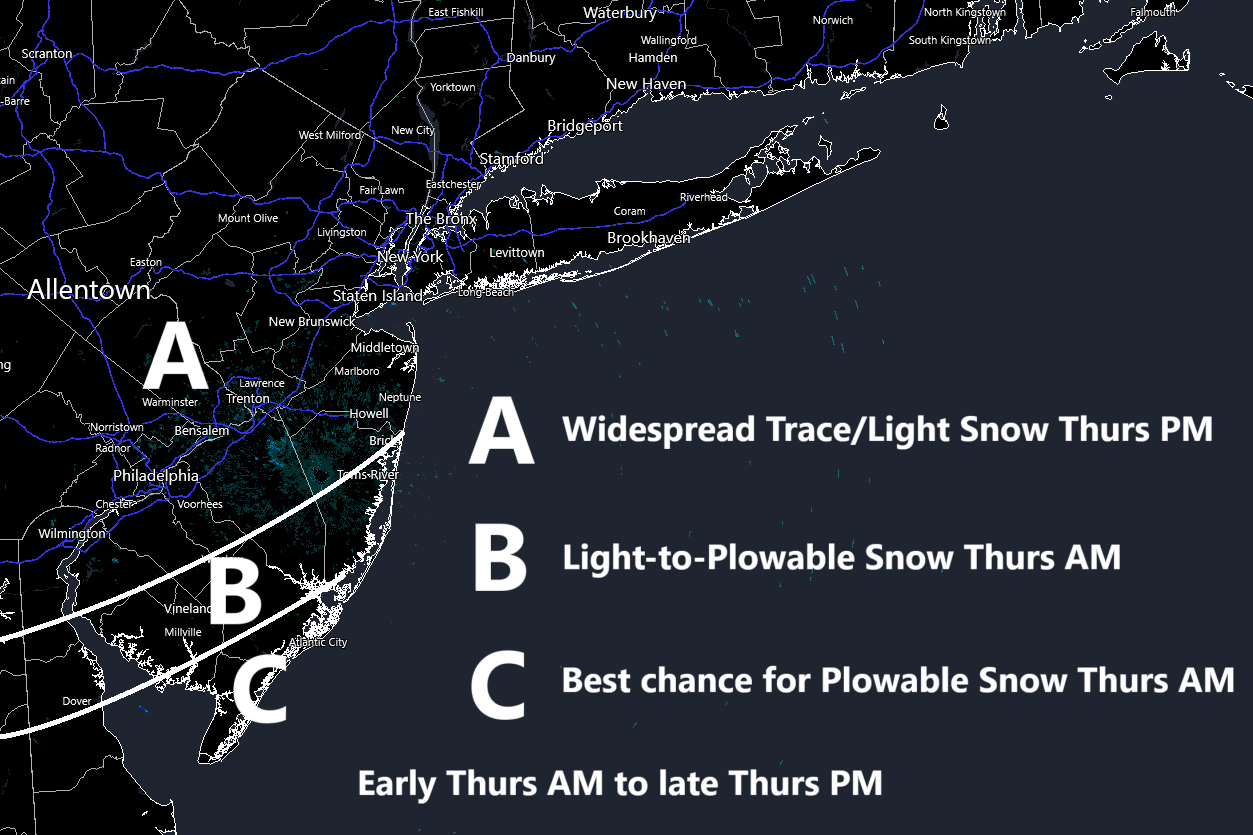
Basically, a coating satisfies zones A and B on the low side and 2 inches satisfies zone C on the low side. I at least think that is very doable at this point and this allows for increased totals tomorrow, if needed, should the next 24 hours of model data run mor favorably for snow. Please do not ask for additional amount details as the answer will be the same for everyone… Ideas today (Tuesday), amounts tomorrow (Wednesday), storm grazes through SENJ on Thursday.
Otherwise, the same ideas and principles remain for this week regardless how much the system grazes SENJ…cold as heck through Friday, moderation starts this weekend, and a milder week next week to close out February. Tonight’s 00Z and tomorrow’s 12Z are very critical runs heading into this system as they will determine our specific map amount for tomorrow.
In English: We’re 36 hours away from this system potentially grazing SENJ and it’s looking more uncertain than ever. A phase and potential IVT are involved which means a lot can happen in either direction. This is not like a single low, clipper, or lake effect event. This involves a system of moving parts that need to come together at the perfect time. If they do (lower chance) then there will be surprising snow amounts into at least SENJ. If they don’t (better chance) then the entire region might be looking at just a coating to an inch situation with lollipops to 2 absolute max. The above map illustrates my current thoughts. A detailed map with specific maps and more detailed timing will come tomorrow (if the system is still even on the table). I wish I had more for you at this juncture. But I don’t. Have a great rest of your Tuesday night and please be safe! JC
Premium Services
KABOOM Club offers ad-free content, inside info forecast discussion, your questions answered, and early storm impact maps and video releases (ahead of the public). At $1.99 per month, it’s an extremely feasible way to show additional support for Weather NJ and you can can turn it on and off for however many months you wish. Think of it as a tip jar with perks. The public eventually sees all info discussed in premium areas. Available onFacebook or Patreon.
My Pocket Meteorologist (MPM), in partnership with EPAWA Weather Consulting, offers professional/commercial interests, whose businesses depend on outdoor weather conditions (snow plowing, landscaping, construction, etc.), with hyper-local text message alerts/forecasts and access to the MPM premium forum—the most comprehensive and technical forecast discussion available for PA and NJ.
Jonathan Carr (JC) is the founder and sole operator of Weather NJ, New Jersey’s largest independent weather reporting agency. Since 2010, Jonathan has provided weather safety discussion and forecasting services for New Jersey and surrounding areas through the web and social media. Originally branded as Severe NJ Weather (before 2014), Weather NJ is proud to bring you accurate and responsible forecast discussion ahead of high-stakes weather scenarios that impact this great garden state of ours. All Weather. All New Jersey.™ Be safe! JC


LOCAL FORECAST | INTERACTIVE RADAR | LATEST NJ WEATHER ALERTS | WEDDING FORECAST| PRIVACY POLICY
© Copyright 2025 Weather NJ LLC. All Rights Reserved.
Some information that can be found on our website is provided by a private weather station and is not an officially recognized station for weather reporting. Though we always strive to achieve accurate reporting for our own use, it is important that you do NOT depend on the data provided here for any purpose.
