Snowstorm Pattern Detected

Discussion: I hope everyone is enjoying the holiday season. Things are about to get interesting and busy in the new year. But before we discuss that, a quick forecast for the rest of this year.
We’re right smack in the middle of an above average temperature period (mild for December). Like other moderations and warmups since Thanksgiving, this is a transient warmup nested between periods of prolonged cold. The warmup ends on New Year’s Day before we enter another prolonged period of cold. We had some rain yesterday (Saturday) and last night but we’re in a lull today (Sunday). I expect rain to return late tonight (Sunday)/early Monday AM and taper off by daybreak Monday morning. Daytime hours on Monday and Tuesday look dry but we’ll still be mild with mixed skies being in the warm sector feeding the Great lakes low. The last piece of rain then pushes through with a weak synoptic disturbance late New Year’s Eve into New Year’s Day. Looks like another overnight rain like tonight/tomorrow (Sunday/Monday). This last rain system will then usher in the cold. Jan 1 should be transitional and Jan 2-forward should be cold…below average for January.
The change to a prolonged colder pattern has high confidence on long-range ensemble data forecasting. It is supported by several teleconnections and oscillation-based forecasting methods. The El Nino Southern Oscillation (ENSO) is and will remain in a weak La Nina state. Currently with the ENSO, it’s more about its neutrality and what it’s not (El Nino) rather than what it is (La Nina). The Madden Julian Oscillation (MJO) is modeled to push through the favorable cold/snowy east coast phases of 7-8-1 between now and as far out as we can comfortably see (Mid-January). The MJO indicates the location of the best tropical forcing between Indonesia and the International Date Line (IDL). Phase 8-1 are right near the IDL which correlates to the Eastern Pacific Oscillation (EPO) and Pacific North American (PNA) relationship. It forces an E Pacific trough (-EPO) that feeds into a W US ridge (+PNA). The data is also unanimous on a blocking ridge signal over Greenland, also known as a negative phase of the North American Oscillation. The Arctic Oscillation is also modeled negative which means that the N Hemisphere’s coldest air will be allowed to spill southward to lower latitudes, especially between the W US and Greenland ridges (cross-polar flow).
So, to summarize the first two weeks of January, we will have a weak La Nina, an MJO traversing from phase 7->8->1, and a -EPO/+PNA/-NAO/-AO pattern. The last time I saw this was Winter of 2013-2014 which was known for a lot of snow and extremely cold temperatures. Remember the Polar Vortex Outbreak Craze? That was Jan-Feb 2014. The cold returns Jan 2 and gradually gets colder through the first week of January. Then we see a massive reloading/reinforcement of Arctic cold for the Jan 8-12 period. I wouldn’t be surprised to see record-breaking cold values in that Jan 8-12 period. At the very least, I expect dangerous pipe-bursting extreme cold. Okay, so our current warm and rainy conditions will become cold and favorable for snow starting Jan 2 through as far as we can see into January. Now let’s talk snowstorm potential.
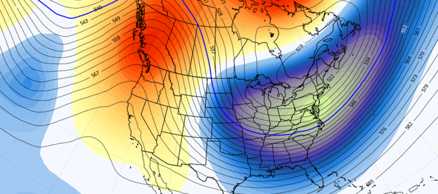
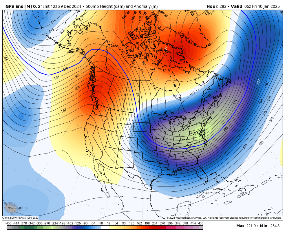
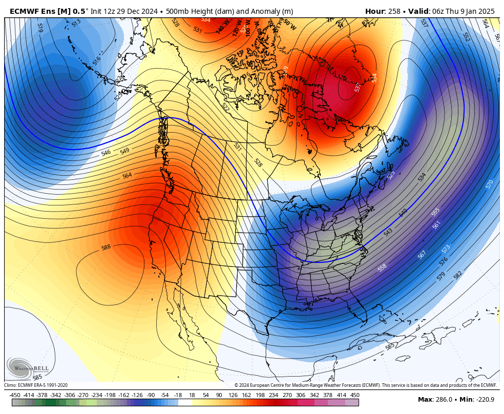
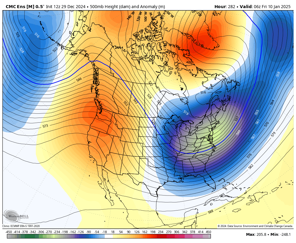
Everything I’ve described above represents the shift towards a pattern that is considered favorable for snowstorm support. It doesn’t guarantee a snowstorm hits your specific backyard location. But it does suggest that at least a few opportunities for snowstorms are possible. Currently, we’re looking at two specific storm signals, Jan 4-8 and Jan 8-12. The actual storms themselves would not be 4 days long, more like a 12-18 hour period of snowfall within that storm signal window. It all depends on which waves from the polar and subtropical jets decide to spin up the coast together on the front of the E US trough. At this point I am still just looking for the ”W US ridge, E US trough, and Greenland block” pattern to hold on model guidance, which it is. I am only paying attention to upper level 500mb prognostication to ensure this pattern holds. It does not makes sense to look at surface solutions yet. Believe me, I know they are looking wild. The overnight Euro KABOOMED the entire state of NJ around Jan 6-7. Other models have done the same. But models are also losing it at the surface on some runs. Again, focus on the upper-level look from this point, not the knee-jerking surface output that unfortunately populates all your weather app auto forecasts. Those forecasts will snap into play a few days before the storm…but they won’t be accurate until the upper levels are ironed out. For reference, here are today’s 12Z fresh ensemble mean outputs for 500mb Geopotential Height Anomalies from the three major GFS, Euro, and Canadian model data suites. This is the best data you can use from this range for the Jan 4-12 storm signals and they are all screaming snowstorm(s):


In English: Expect some more rain late tonight into tomorrow morning (Sunday PM into Monday AM) and then late New Year’s Eve into New Year’s Day morning (Tues PM into Wed AM). Otherwise expect mild and dry daytime hours for today, Monday and Tuesday with a mix of sun and clouds. Temperatures then start dropping on the eve of Jan 1 and really drop for the period starting Jan 2 and ending no earlier than Jan 14 (as far as we can see and analyze temp trends). The Jan 8-12 period might feature record cold temperatures…but at the least should feature extreme and dangerous cold. Watching two specific winter storm signals, one between Jan 4-8 and the other between Jan 8-12. It’s too soon for details only to confirm that the pattern looks very favorable for 12-18 hour snowstorms in those periods. Everyone buckle up because winter is about to kick our butts IMO. More analysis to come as we closer approach. Be safe! JC
Premium Services
KABOOM Club offers ad-free content, inside info forecast discussion, your questions answered, and early storm impact maps and video releases (ahead of the public). At two bucks per month, it’s an extremely feasible way to show additional support for Weather NJ. Think of it as a tip jar with perks. Available onFacebook or Patreon.
My Pocket Meteorologist (MPM), in partnership with EPAWA Weather Consulting, offers professional/commercial interests, whose businesses depend on outdoor weather conditions (snow plowing, landscaping, construction, etc.), with hyper-local text message alerts/forecasts and access to the MPM premium forum—the most comprehensive and technical forecast discussion available for PA and NJ.
Jonathan Carr (JC) is the founder and sole operator of Weather NJ, New Jersey’s largest independent weather reporting agency. Since 2010, Jonathan has provided weather safety discussion and forecasting services for New Jersey and surrounding areas through the web and social media. Originally branded as Severe NJ Weather (before 2014), Weather NJ is proud to bring you accurate and responsible forecast discussion ahead of high-stakes weather scenarios that impact this great garden state of ours. All Weather. All New Jersey.™ Be safe! JC


