

Snowstorm Chances Increasing for Wed-Thurs
Discussion: There’s a lot to talk about. I think it’s better to break it down by time period and hazard rather than by hazard type only. So, let’s start with right now and walk through next week.
Today’s Snowy Burst: As I write this, I’m at 39F in SENJ with moderate snow approaching from the W. I expect the moderate snow to take my surface temp down to maybe 35-37F for a bit before the warm air advection continues to push in from S to N and changes me over to a brief period of sleet before going to all rain. This should be the case for all of NJ S of I-195…a brief cooldown with initial snow burst followed by the resumption of warming S to N. Areas N of I-78 (where the surface is colder) will accumulate snow better today prior to the changeover. By midnight tonight, I expect all of NJ to be above freezing at the surface with rain falling. Extreme NNJ will be the last to changeover, possibly a little after midnight.
Sunday Rain and Wind: I expect rain to fall from the point of changeover on Saturday until about 7am Sunday morning. I then expect a break/lull in rain for Sunday morning until Sunday afternoon. During this time, New Jersey will rage in the warm sector. By that I mean spiking warm temperatures and high winds into the SENJ coast from the S. The sun may poke through during this time and SNJ may hit 60F. Away from the ocean will be lesser wind gusts for Sunday daytime hours, but coastal areas could see S/SE wind gusts in the 40-60mph range. When precipitation returns from the W, it could very well be in a convective form…thin linear strips of precipitation more like a thunderstorm squall setup of heavy rain rather than a wide slug of moderate rain. I wouldn’t be surprised to see thunderstorms embed into the squalls. The last squall should push through sometime between 4-7pm Sunday with clearing skies behind. Winds will then switch to the NW or W/NW and possibly gust 40-60mph again from Sunday evening into Monday.
Monday-Wednesday Morning Cold: This time period will be dry but very cold, especially once the cold air advection winds relax at some point later Monday. High temps Monday should max in the 25-25F range N to S. Monday night into Tuesday morning overnight lows should dip into the single-digits for NWNJ elevations and teens for the rest of NJ by 7am Tuesday. Tuesday highs should range from 20-28 N to S. Tuesday night into Wednesday morning overnight lows should dip back into the single-digits/teens by 7am Wednesday morning. Wednesday highs should again stay below freezing for most of NJ. You can see why I’ve been calling this period a cold stage setter for the anticipated snowstorm.
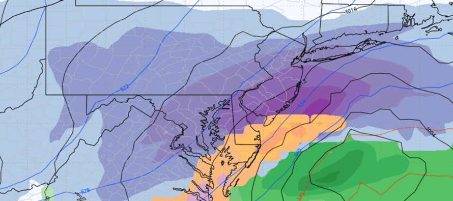
Wednesday-Thursday Snowstorm: A surface low is expected to spawn off the coast of GA around 5pm on Wednesday. This low should then track NE along the SE US coast, over OBX and then either over or just SE of the 40N/-70W benchmark by 5pm on Thursday. The surface low only represents the southern stream energy. There is also northern stream energy that will have its own precipitation with it that will couple up with (phase) with the southern stream energy. This should essentially create a window of 5pm Wednesday to 5pm Thursday as the period of precipitation for the storm. This might rock a few hours earlier or later as we approach closer. But the general idea of timing is currently evolving as such. With each model run, I am becoming more confident that at least some of NJ will KABOOM. Current model guidance favors I-95 and SE with more snow (the jackpot) than to the NW of I-95 (still significant snow). However, I expect changes in where the jackpot will be…the typical windshield wiper effect. At times there will be heartbreak. At other times there will be euphoric fantasy. It all depends on whether you love or hate snow and where you are. My gut feel from the upper level look is leaning towards the idea of a jackpot maybe S of I-80 and SE of I-287 (what I refer to as the entire lower-2/3 of NJ). This would leave only NWNJ elevations just outside the jackpot. We’ll see. Either way, we have another 24 hours of model runs before I decide to issue at least a KABOOM watch for the Wednesday PM-Thursday PM snowstorm potential. I’ll make that decision tomorrow night (Sunday night).
In English: Snow starts today and changes to rain from S to N with an icy transition. Rain lasts from tonight through Sunday night with a break Sunday morning/early afternoon. Very windy Sunday out of the S, especially for the coastal areas of SENJ. Sunday PM rain could return with thunderstorms and brief periods of downpours. Winds pick back up out of the NW (very gusty) for Sunday night into Monday morning. Your probably seeing the high wind warnings for such. Monday-Wednesday looks very cold. Wednesday evening through Thursday evening is the period for the snowstorm, capable of delivering major snow accumulations to New Jersey. I’ll see you after another 24 hours of model guidance and live observations upstream. Have a great Saturday night and please be safe! JC
Premium Services
KABOOM Club offers ad-free content, inside info forecast discussion, your questions answered, and early storm impact maps and video releases (ahead of the public). At $1.99 per month, it’s an extremely feasible way to show additional support for Weather NJ and you can can turn it on and off for however many months you wish. Think of it as a tip jar with perks. The public eventually sees all info discussed in premium areas. Available onFacebook or Patreon.
My Pocket Meteorologist (MPM), in partnership with EPAWA Weather Consulting, offers professional/commercial interests, whose businesses depend on outdoor weather conditions (snow plowing, landscaping, construction, etc.), with hyper-local text message alerts/forecasts and access to the MPM premium forum—the most comprehensive and technical forecast discussion available for PA and NJ.
Jonathan Carr (JC) is the founder and sole operator of Weather NJ, New Jersey’s largest independent weather reporting agency. Since 2010, Jonathan has provided weather safety discussion and forecasting services for New Jersey and surrounding areas through the web and social media. Originally branded as Severe NJ Weather (before 2014), Weather NJ is proud to bring you accurate and responsible forecast discussion ahead of high-stakes weather scenarios that impact this great garden state of ours. All Weather. All New Jersey.™ Be safe! JC


LOCAL FORECAST | INTERACTIVE RADAR | LATEST NJ WEATHER ALERTS | WEDDING FORECAST| PRIVACY POLICY
© Copyright 2025 Weather NJ LLC. All Rights Reserved.
Some information that can be found on our website is provided by a private weather station and is not an officially recognized station for weather reporting. Though we always strive to achieve accurate reporting for our own use, it is important that you do NOT depend on the data provided here for any purpose.
