Snowfall Detected – Tomorrow Night

Discussion: First, let’s level some expectations. The snow potential for tomorrow (Thursday) into Friday is not a big deal. Given the time of year and surface temperature profile, it will be hard for significant accumulations to stack up outside of higher elevations. I could see snow falling at times as far S as CNJ/parts of SNJ but no chance of stickage. This is, however, a big deal because of the precipitation associated with a synoptic-scale disturbance. We all know that rain is needed and this is our best shot of putting moisture into the ground whether as rain (immediately) or snow (into the ground after melting).
Let’s cover the rain first. We’re dealing with a Miller-B transfer situation. We have an upper low over the Great Lakes now as a primary lakes surface low transfers to a secondary low over NNJ. The transfer hasn’t happened yet but we do have an occluded front that will push a slug of rain through NJ starting late-tonight and ending sometime mid-day tomorrow. Expect the rainfall to appear linear/front-like through PA but then expand and fill in once over NJ. Rainfall amounts should vary with NNJ likely in the 1-1.5 inch range and SNJ in the .25-.75 inch range. This will be all rain for all of NJ.
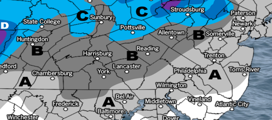
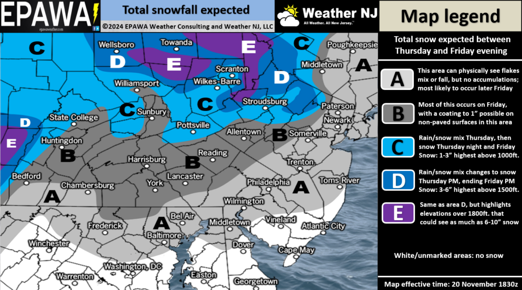
The snow potential enters the chat later Thursday evening as the upper low stacks above the secondary low over the NNJ/NEPA/NY State region. The upper low will allow colder air to reach the surface via dynamic cooling and the precipitation will cool the air vis evaporative cooling. This should be enough to take the surface closer to freezing N of I-78/NW of I-287 but not likely for areas S and E of that NNJ zone. Elevations above 1200 ft have the best chance for stickage but again with only marginal surface temps (close to freezing but not below). The rest of NJ will struggle to sink below the 35-40 degree range which is why most now for the lower 2/3 of NJ will be conversational. It does, however, look like NWNJ elevations could break out of the conversational flake status into trace-to-light accumulations between Thursday night and Friday morning. Here is our initial snow map for Thursday-Friday:

We’ll probably update this map tomorrow as a final call heading into the disturbance. But for now, this is the general idea. It’s important when considering model analysis to use snow depth at this point, especially when snow ratios are going to be well-under 10:1 with temps above 32. When temps are near 32, it makes sense to use 10:1 maps. When temps are much colder and higher snow ratios come into play, it’s best to use Kuchera maps. We’ll cover this more throughout this snow season.
Snow/rain should wind down by Friday evening and allow a colder breezy Saturday-Sunday to play out. We then turn attention to two disturbances next week. The first looks like a warmer miss to the N of NJ (Monday-Tuesday). Models, however, are becoming more excited about a Thanksgiving/Black Friday/Saturday snowstorm. This signal is mainly due to a negative phase of the Eastern Pacific Oscillation and the downstream impacts of such over the E US. It’s something I will be tracking closely.
In English: Rain moves in tonight (Wednesday) and ends by tomorrow (Thursday) afternoon…the most significant rainfall we’ve had for a while. I think a quarter-inch is bankable for most of NJ but some areas could see an inch or more. NNJ is favored for the most. SNJ the least. But again, likely at least a quarter inch for all. We then see a break Thursday before precipitation rebuilds Thursday night into Friday. Some of this precipitation will likely fall as snow and possibly accumulate for NWNJ elevations. Our snow map above represents our best evidence-based call on what to expect by Friday when precipitation ends. We then see a breezy colder Saturday and Sunday while we keep our eyes on a possible Thanksgiving Day-Black Friday snowstorm. Have a great rest of your Wednesday and please be safe! JC
Premium Services
KABOOM Club offers inside info forecast discussion, your questions answered, and early storm impact maps (ahead of the public). At a buck per month, it’s an extremely feasible way to show support.
My Pocket Meteorologist (MPM), in partnership with EPAWA Weather Consulting, offers professional/commercial interests, whose businesses depend on outdoor weather conditions (snow plowing, landscaping, construction, etc.), with hyper-local text message alerts/forecasts and access to the MPM premium forum—the most comprehensive and technical forecast discussion available for PA and NJ.
Jonathan Carr (JC) is the founder and sole operator of Weather NJ, New Jersey’s largest independent weather reporting agency. Since 2010, Jonathan has provided weather safety discussion and forecasting services for New Jersey and surrounding areas through the web and social media. Originally branded as Severe NJ Weather (before 2014), Weather NJ is proud to bring you accurate and responsible forecast discussion ahead of high-stakes weather scenarios that impact this great garden state of ours. All Weather. All New Jersey.™ Be safe! JC


