Snow/Rain and then COLD!

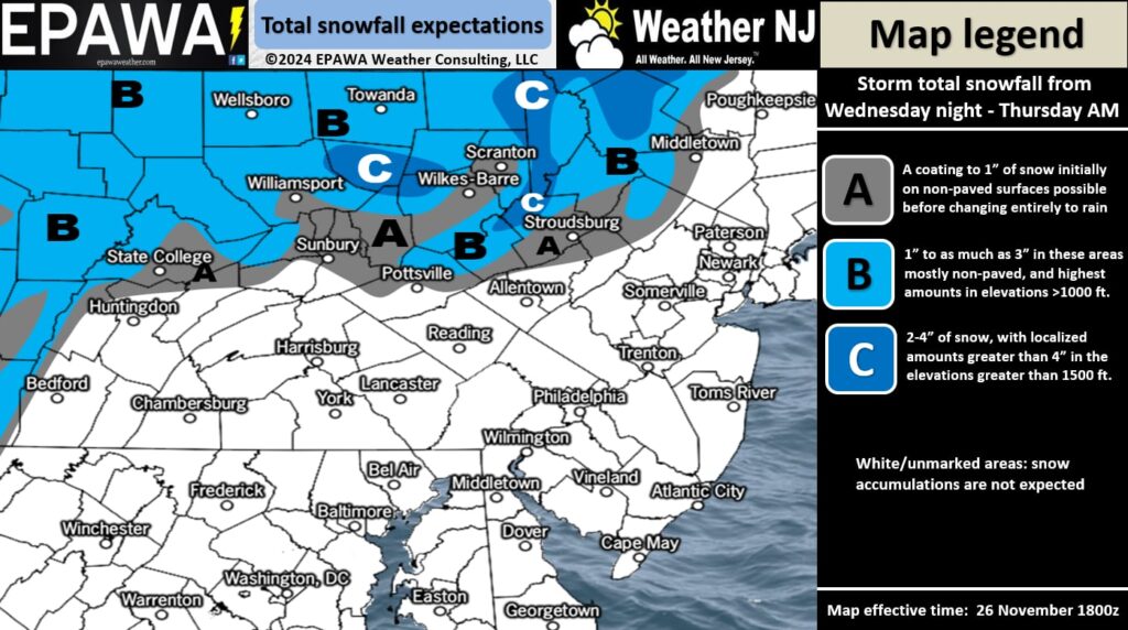
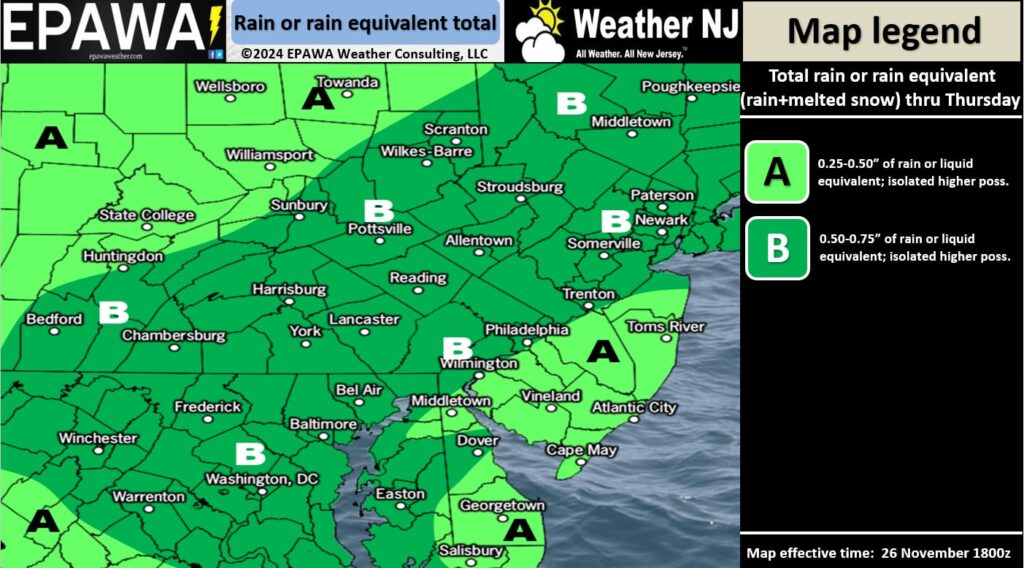
Discussion: Another round of beneficial rainfall is approaching New Jersey for Thanksgiving Day. Areas N of I-80/NW of I-287, mainly Sussex and N Warren Counties are subject to more snowfall but nowhere near the accumulations that fell and stuck last week. All other NJ areas should expect cold rain. After that, the expected wintry air mass will settle in and stick around well into December.
We know that the upper jet guidance (observed at 250mb) is currently in a zonal pattern across the US and over NJ and will be dipping just to the S of NJ Thursday night-forward. We’re already under below-average geopotential heights (observed at 500mb) and will gradually transition to well-below average as the 540dam line pushes S of NJ several times over the next 14 days. This is a very wintry pattern for early December. This Thanksgiving snow didn’t work out (outside of NWNJ elevations) however there are several winter storm signals brewing between the Dec 3-11 period.
Once the precipitation ends on Thanksgiving Day afternoon, the colder air mass will settle in with strong winds over the Great Lakes blowing towards NJ on Friday. This will allow the chance for lake effect flurries, snow showers, or even a squall or two. Flizzard type stuff. PA and NY State look much more favorable for this but NJ is on the hook too, especially NWNJ. Otherwise, the period from Black Friday through about Dec 3 looks cold and dry. We’re talking afternoon highs staying in the 30s with bitter cold overnights. It’s not until the aforementioned Dec 3-11 period that snow chances become much more alive.
So for now, expect rain (snow for extreme NWNJ) to move in early on Thanksgiving Day, likely pre-dawn. Expect a steady rainfall through about afternoon of Thanksgiving Day. Should end by early afternoon for WNJ and late afternoon for ENJ. As far as rainfall amounts, expect a half-inch or slightly more for NNJ and a half-inch or slightly less for SNJ (NJ divided in half at I-195). Again, much needed! Here’s our snow and rain impact maps:


In English: Rain moves in early Thanksgiving Day morning (pre-dawn) and ends by afternoon from W to E. .25 to .75 inches of rainfall are expected…lower end of range for SNJ and higher end for NNJ. While this is not “plan cancelling” weather, please allow for additional delays in travel. Extreme NWNJ (Sussex and N Warren Counties) could see light snowfall accumulations but will be challenging to push and hold surface temps down to 32. Most of NJ should expect rainfall temperatures in the 40s with only NNJ seeing sub-40 temps. Like last week, likely an elevation snow event only above 1000ft in Sussex and Warren. We then turn very COLD heading into this weekend and for a while. We’re talking highs in the 30s and lows in the teens/20s for a while into December. Black Friday-Dec 3 looks cold and dry. Dec 3-11 looks cold and possibly stormy. More to come. Everyone have a wonderful Thanksgiving and please be safe! JC
Premium Services
KABOOM Club offers ad-free content, inside info forecast discussion, your questions answered, and early storm impact maps and video releases (ahead of the public). At two bucks per month, it’s an extremely feasible way to show additional support for Weather NJ. Think of it as a tip jar with perks. Available onFacebook or Patreon.
My Pocket Meteorologist (MPM), in partnership with EPAWA Weather Consulting, offers professional/commercial interests, whose businesses depend on outdoor weather conditions (snow plowing, landscaping, construction, etc.), with hyper-local text message alerts/forecasts and access to the MPM premium forum—the most comprehensive and technical forecast discussion available for PA and NJ.
Jonathan Carr (JC) is the founder and sole operator of Weather NJ, New Jersey’s largest independent weather reporting agency. Since 2010, Jonathan has provided weather safety discussion and forecasting services for New Jersey and surrounding areas through the web and social media. Originally branded as Severe NJ Weather (before 2014), Weather NJ is proud to bring you accurate and responsible forecast discussion ahead of high-stakes weather scenarios that impact this great garden state of ours. All Weather. All New Jersey.™ Be safe! JC


