

Snow and Ice Storm Developing
Discussion: High temperatures in NJ today ranged from about 38-53 N to S. The front-side of anticyclonic flow (N flow) associated with high pressure approaching from the W will drop temperatures much colder through sunset and into overnight hours tonight—bottoming out in the ~18-28 range N to S. High temps will then come up to about the 32-38 range N to S on Wednesday (a fairly cold day) before dipping again into evening hours to about the 22-32 range just before midnight. That’s likely as low as we go before Warm Air Advection (WAA) begins aloft and precipitation starts falling.
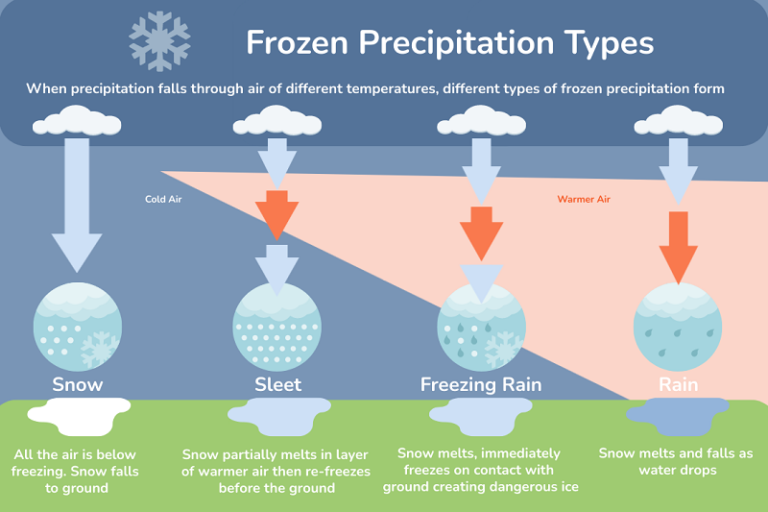
Warm air will first push into SWNJ from the SW and continue N/NE-ward until reaching NNJ. Again, first it moves in aloft and then later at the surface as it’s hopping over the cold air being dammed in from the NE high pressure. Here’s an infographic showing how this wedge setup influences the generation of different precipitation types. Snow and rain are straightforward. Sleet and freezing rain are more complex as the depth of the warm layer determines if melted snowflakes re-freeze before hitting the ground (sleet) or re-freeze after hitting the ground (freezing rain). It all starts as snow though as the precipitation generation zone is high enough aloft to remain below freezing at all times. In NJ’s case, the warmer air wedge coming in from the right side of the following infographic, will be moving from SW to NE across NJ:
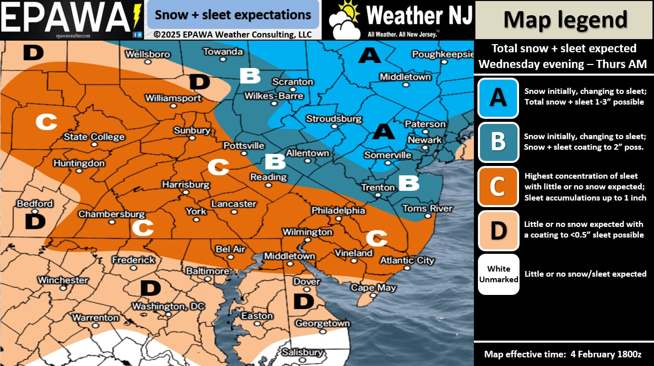
We believe, in this case that sleet could be the most dominant form of precipitation for much of NJ (especially CNJ and SNJ) due to a shallower warm layer hanging in place for a decent chunk of the precipitation period. Otherwise snow will be brief across the coastal plain (lasting longer for NNJ/CNJ) before the transition to ice and rain. SENJ should see the quickest change to ice and then rain after a quick possible snowy burst. NNJ (away from NYC) stands the best chance to see snow accumulations build up before going over to at least sleet or freezing rain. It’s hard to say how N and W the rain line makes it by the end of the storm. But we feel it should at least make it to the I-78/I-287 elbow shaped corridor.
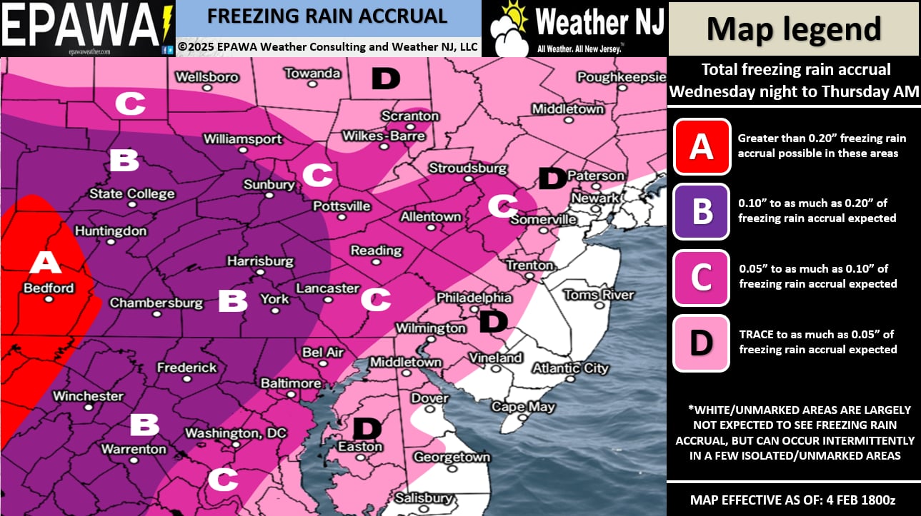
Look, we have 4 precipitation types with three dividing lines that will chaotically move from S to N throughout the period of precipitation, which for NJ looks like 10pm Wednesday night through 6pm Thursday. It’s impossible to nail the exact outcome. But you can generally deduce a snow-to-ice-to-rain situation SE of I-78/I-287 and a snow-to-ice situation NW of I-78/I-287. And about the most insightful information we can add is that a slizzard (sleet fest) should dominate much of the headline, nested between some front-end snow and back end rain (SE of I-78/I-287). Here are two maps, one for snow and sleet pellets and the other for freezing rain accrual.
The future forecast has not changed. We turn milder after this system until Saturday then drop in temps for another possible slizzard-like system Saturday night into Sunday. Then we stay cold into a period I am very interested for snow with minimal ice…Feb 10-15. I am currently seeing two separate events in that window but we are too far out to track seriously. These next two systems, in their wakes, will determine the thermal boundary for the next lows to track along. But the general idea is that each system should get slightly colder. A fun February ahead. Seems like we have some runners on the bases for this top of the 7th inning that should be from tomorrow through about Feb 15th.
In English: A wintry event is developing in the form of a snow-to-ice-to-rain storm. We have two maps above, one for snow and sleet pellets (occurs fist) and another for freezing rain accrual (occurs after snow and sleet). After freezing rain, we expect all areas S of I-78 and SE of I-287 to change to rain to end. Areas N and W of such could end as sleet or freezing rain with very little plain rain. It starts around 10pm tomorrow (Wednesday night) and ends by 6pm Thursday with Thursday rush hour/school bus time falling in the middle of the slizzard. Expect delays across SNJ and delays/closures across NNJ. Wash rinse repeat for the weekend and then we turn attention to some more snow/less ice possibilities next week. Updated maps tomorrow if needed. Have a great rest of your Tuesday and please be safe! JC
Premium Services
KABOOM Club offers ad-free content, inside info forecast discussion, your questions answered, and early storm impact maps and video releases (ahead of the public). At two bucks per month, it’s an extremely feasible way to show additional support for Weather NJ. Think of it as a tip jar with perks. Available on Facebook or Patreon.
My Pocket Meteorologist (MPM), in partnership with EPAWA Weather Consulting, offers professional/commercial interests, whose businesses depend on outdoor weather conditions (snow plowing, landscaping, construction, etc.), with hyper-local text message alerts/forecasts and access to the MPM premium forum—the most comprehensive and technical forecast discussion available for PA and NJ.
Jonathan Carr (JC) is the founder and sole operator of Weather NJ, New Jersey’s largest independent weather reporting agency. Since 2010, Jonathan has provided weather safety discussion and forecasting services for New Jersey and surrounding areas through the web and social media. Originally branded as Severe NJ Weather (before 2014), Weather NJ is proud to bring you accurate and responsible forecast discussion ahead of high-stakes weather scenarios that impact this great garden state of ours. All Weather. All New Jersey.™ Be safe! JC


LOCAL FORECAST | INTERACTIVE RADAR | LATEST NJ WEATHER ALERTS | WEDDING FORECAST| PRIVACY POLICY
© Copyright 2025 Weather NJ LLC. All Rights Reserved.
Some information that can be found on our website is provided by a private weather station and is not an officially recognized station for weather reporting. Though we always strive to achieve accurate reporting for our own use, it is important that you do NOT depend on the data provided here for any purpose.
