SNJ Snowstorm Approaching

Discussion: This article will cover the final forecast discussion and snow map for tomorrow (Monday) as well as some early thoughts on the weekend potential.
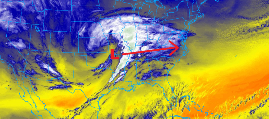
We’ve beaten the physics to death on how the low responsible for Friday night’s light SNJ snow has gone on to become a powerful storm near Newfoundland. This Newfoundland low has worked with the approaching C US storm low to create an area of confluence to the N/NE of NJ and an adjacent area of subsidence to the S of the confluence laying across NNJ. The subsidence will likely rob NNJ and much of CNJ of a higher snow outcome. SNJ however remains on the N side of the jackpot axis extending along and S of the Mason Dixon line. If you draw a line from Philly over to Toms River in N Ocean County, I think this will be the N extent of the potential school-closing/plowable snowfall. I then expect accumulation amounts to increase as you head S from that PHL<->TR line down through SNJ to Cape May. I expect those right along the Delaware Bay in SWNJ down through Cape May to do the best with this system, possibly eyeing up double-digit accumulations if the snow banding cooperates.
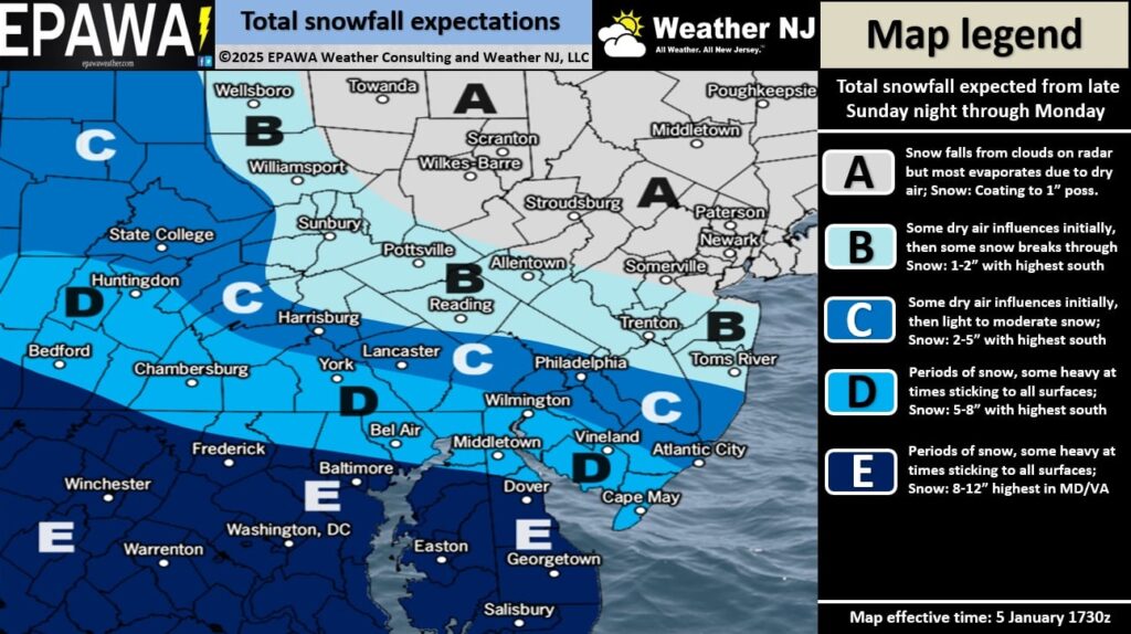
Our updated snow map only makes a small increase for SNJ in general. We’ve upped the higher range of Zone C to allow up to 5 inches of snowfall as far N as that general PHL<->TR line I mentioned above. However, we kept the lower range of Zone C to account for the potential sharp cutoff that could occur from the dry and subsidence. This allows as little as 2 inches to fall as far S as a line drawn from Wilmington, DE to Atlantic City. We feel this is the best way to handle the uncertainty between northern SNJ and southern CNJ…a general 2-5 for Zone C. Zone D then gets changed from 4-8 to 5-8 which isn’t that big of a deal. Again, it just allows a more potent snowy precipitation shield across zones C and D. Whether or not some of SWNJ coast into Cape May creeps into zone E are yet TBD, not confident enough to forecast such, and will be determined by banding intensity of snowfall. With that said, here’s our updated snow map.
Now let’s talk about what could bust or boom. If the dreaded RGEM model is correct, everything would be further S and SNJ would even see the lower amounts of the forecasted ranges, even less. The RGEM has been on its own as a southern outlier. If the HRRR is correct, then the precipitation shield would be more expansive on the N side of everything and zone D possibly S side of C could boom above the 2-5 range. However most model guidance is in-between the two outliers and concentrated on a solution more like our snow map.

Look for heavier mesoscale banding to possibly occur across Zones C/D. Thundersnow would be a good indicator that convection is over-performing. This could be a reason that the forecast booms higher than expected map amounts. Remember, this will be higher-ratio snow (not the best for snowmen and snow balls) so it will stack up quickly if any meso bands do form.
Look for a lot of frustrated people in NNJ, possibly CNJ, to complain about seeing snow on the radar but nothing reaching the ground. The N side of this is so dry with the confluence-powered subsidence that virga is very possible (precipitation that evaporates before reaching the ground). I expect to see this in NNJ. CNJ is on the fence with this. This will be much less of an issue for SNJ.
Other than that, we’ve got a Mid-Atlantic Mauler pushing down the Mason Dixon line towards NJ today. Snow should arrive in the early AM hours for SWNJ and make it across to SENJ by 3-6am. Snow should reach its N extent by 10-11am and then taper off between Monday afternoon and evening. Some tail-end snow could scrape SNJ around midnight into early Tuesday AM hours but should shut off by sunrise Tuesday morning. The N 2/3 of NJ should shut off before Midnight Monday night. I’d say the meat and potatoes of snowfall for SNJ are between 4am and 4pm Monday.
Now let’s talk about the weekend. The third signal we identified in the last part of December fell off model guidance around the new year but has trended back. The first one was the Friday night light SNJ snow event. The second it tomorrow’s SNJ snowstorm. This third would be in the form of a low that forms in the Gulf of Mexico Friday morning, tracks across the SE US Friday night-Saturday morning and then near or slightly offshore of NJ Saturday evening into Sunday morning. A wintry Nor’easter. We know this to be a Miller-A snowstorm track. It could potentially bring heavy snowfall to the Mid-Atlantic and NorthEast US Saturday into Sunday and traditionally favors NNJ/WNJ over SNJ/SENJ. Possibly a perfect complement to tomorrow’s SNJ snowstorm. The main reason right now as to why the models are showing either a snowstorm or no snowstorm has to do with the upper low that forms in the SW US. If the trough energy scoops this up and carries it to the E US, then we’ll see a classic snowstorm. If it leaves the energy behind, then trough will not have enough axis-rotating energy to turn the storm up the coast…instead it will get sheared way out to the S off the SE US. The attached Canadian is an example of that scenario. The attached Euro and GFS illustrates what happens when the energy is scooped and carried over to the E US (possibly a solid wintry nor’easter). I will be watching this SW US piece of energy on model guidance over the next 2 days or so as the Monday system comes and goes. By Monday night/Tuesday morning, we’ll have a much better idea of the probability of a weekend snowstorm. Right now, it’s a fantasy signal that has entered the long-range forecasting period.
In English: Snow arrives before sunrise Monday morning, peaks between late-morning-afternoon on Monday and then tapers off through Monday afternoon-evening…possibly falls across extreme SNJ until Tuesday AM hours. Zones C and D on our map above have the best chance for school closure and plowable snowfall. Tuesday-Friday then look cold as heck featuring likely the coldest air mass of this pattern. Watching Saturday into Sunday for a possible larger snowstorm that would favor the areas missing out tomorrow (NNJ/CNJ) but possibly bring mixing and rain to the areas hit hardest tomorrow (SNJ/SENJ). Serious tracking for the weekend storm will begin if still showing tomorrow night (Monday night). For now, all eyes on the SNJ express. Live observations will begin tonight. The above snow map is our final forecast heading in. Be safe! JC
Premium Services
KABOOM Club offers ad-free content, inside info forecast discussion, your questions answered, and early storm impact maps and video releases (ahead of the public). At two bucks per month, it’s an extremely feasible way to show additional support for Weather NJ. Think of it as a tip jar with perks. Available onFacebook or Patreon.
My Pocket Meteorologist (MPM), in partnership with EPAWA Weather Consulting, offers professional/commercial interests, whose businesses depend on outdoor weather conditions (snow plowing, landscaping, construction, etc.), with hyper-local text message alerts/forecasts and access to the MPM premium forum—the most comprehensive and technical forecast discussion available for PA and NJ.
Jonathan Carr (JC) is the founder and sole operator of Weather NJ, New Jersey’s largest independent weather reporting agency. Since 2010, Jonathan has provided weather safety discussion and forecasting services for New Jersey and surrounding areas through the web and social media. Originally branded as Severe NJ Weather (before 2014), Weather NJ is proud to bring you accurate and responsible forecast discussion ahead of high-stakes weather scenarios that impact this great garden state of ours. All Weather. All New Jersey.™ Be safe! JC


