Sept 6: SE US Irma Landfall Likely

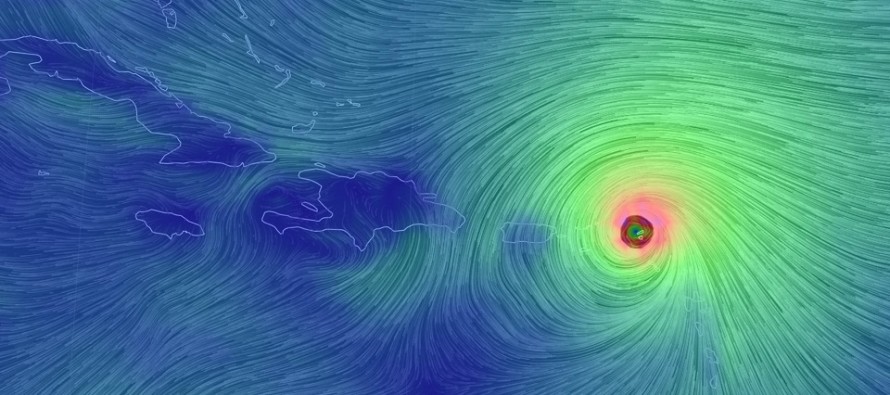
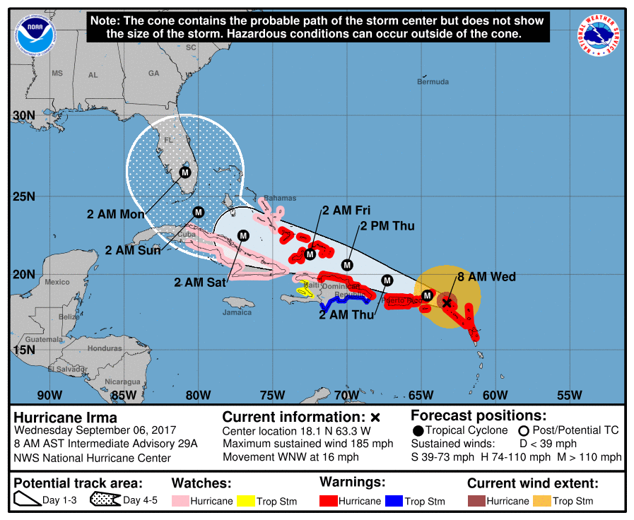
Discussion: Major Hurricane Irma has directly hit the northern Lesser Antilles overnight. I’m sure you will see images and footage today as Irma moves away from said area. The next immediate concern is Puerto Rico. The latest guidance indicates an eye passage “just” N of Puerto Rico but not far enough N to avoid major impact. I’d still leave the possibility on the table for the southern eye wall to scrape N Puerto Rico. The rest of the Greater Antilles including Hispaniola and Cuba remain on alert but should also see a passage slightly to the N of them. The Bahamas are in the worst immediate spot as they will likely take the storm speed + the N side of Irma’s cyclonic flow. The latest update from the National Hurricane Center reflects all of this:

US impacts are still somewhat uncertain but we can narrow it down a little more. Yesterday it became apparent to me that NJ will not be seeing a direct landfall. That has not changed. What has changed are the steering currents that ultimately will turn Irma to the NW and then to the N. Newly-formed Jose, which I believe will sleep with the fish, as well as another upper-level low further E in the Atlantic are projected to weaken the ridge that was almost sending Irma into the Gulf of Mexico yesterday on some models. Instead this allows Irma to interact just a few hairs more with the lifting/departing US trough. What this means is that E FL (from the keys/Miami to Jacksonville), Georgia and South Carolina should be on high alert for potential landfall. The scenario where Irma goes into the gulf and re-curves back into W FL is becoming less likely.
Even if Irma stays just off the coast of E FL, the state of Florida will still see very damaging conditions as Irma will likely maintain more of her strength. There is still a VERY high chance however that at least some portion of the eye wall (highest winds) scrapes somewhere on the E FL coast. There’s still a small chance that Irma rides right up the center of FL. Regardless, once Irma is moving N, whether over all of FL, over the FL coast or just off E FL coast, she will likely turn into the Georgia/South Carolina area towards the path of least resistance. The path of least resistance will be towards the lowering heights over the SE US, not towards the departing trough to the NE. This is why I believe NJ landfall is still off the table…but why FL, GA and SC need to take this threat seriously.
Once Irma is inland over the SE US land she will weaken, especially by the time her remnants make it as far N as New Jersey. If landfall occurs over FL or E FL then NJ rainy and windy impacts would likely be very minimal. If Irma misses E FL and slams into GA/SC then NJ rainy and windy impacts could be stronger but still manageable. Don’t get me wrong, moderate winds and heavy rainfall might still be possible for NJ, just not the super-damaging aspect of the high winds and storm surge. After that, Irma’s remnants will likely be carried away by the mid-latitude westerlies…the same force I believe will ultimately keep Jose out to sea.
In the meantime, Eastern PA Weather Authority Meteorologist Bobby Martrich and myself will be discussing deep technical model analysis in our My Pocket Meteorologist Premium Forum (bottom option). Our conversations in this forum provide even more of a technical discussion than this article including the conclusive insight that helps ultimately drive these articles. While you’re there, have a peek at our other premium products such as our hyper-local text notification system for daily forecasts and severe weather. Thousands of people have signed up for these products and thoroughly enjoy them, especially during the winter months. Not to worry, my free services (daily articles and outlooks) will always remain free as-is. These premium services are mostly for business owners and weather nerds/freaks like me who absolutely have to know the latest info as soon as we learn of it.
In English: Irma will likely make landfall anywhere between the FL Keys/Miami area and South Carolina this weekend. We (NJ) could see some rainy and windy remnants in the early-mid part of next week. The rain and wind that NJ will see will be dependent on how much land Irma passes over before reaching our latitude. If she makes landfall over FL then she will pass over more land and we will see weaker remnants. If she stays just off the FL coast and makes landfall in the GA/SC area then our rainy and windy remnants could be more intense. In either case, I still believe NJ impacts from Irma will be manageable (without the destructive winds and storm surge). Moderate winds and flash flooding would likely be the extent of it and even that is highly speculative. Everyone have a nice Wednesday and please be safe! JC
Jonathan Carr (JC) is the founder and sole operator of Weather NJ, New Jersey’s largest independent weather reporting agency. Since 2010, Jonathan has provided weather safety discussion and forecasting services for New Jersey and surrounding areas through the web and social media. Originally branded as Severe NJ Weather (before 2014), Weather NJ is proud to bring you accurate and responsible forecast discussion ahead of high-stakes weather scenarios that impact this great garden state of ours. All Weather. All New Jersey.™ Be safe! JC


