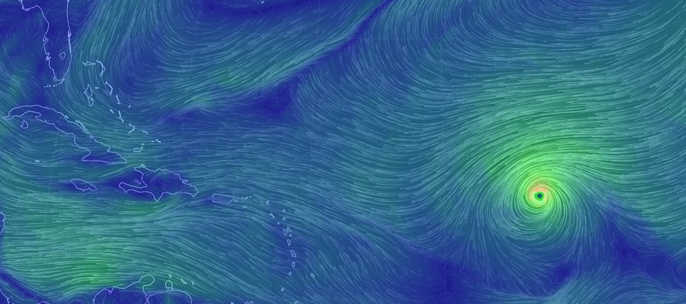
Discussion: Irma’s impact beyond the NE Caribbean is still very uncertain. If you’re here for an exact US landfall prediction then I’m sorry to disappoint. A more practical discussion would be to analyze the modeled steering forces responsible for the recent high-impact US model output. First, here is the current status of Irma via the National Hurricane Center’s 11AM update. The “M” designation indicates major hurricane status. Irma is currently a strong 2:
My first area of focus is between the Azores and Bermuda highs as Irma approaches the Leeward Islands. An upper-level ridge with a W/SW to E/NE axis is driving Irma to the W/SW via its southern-side anti-cyclonic steering currents. An upper-level low then breaks down the Azores ridge but leaves the Bermuda ridge in-tact drifting E slightly. This pivots the axis of steering currents about 60 degrees clockwise which forces Irma to take a turn from W/SW movement to W/NW movement when crossing the ~50W longitude in the ~Monday-Tuesday period.
Most model guidance then takes Irma just NE of Barbuda as a major hurricane. The closer Irma passes to Barbuda, the worse the Leeward Island impacts will be. If Irma can pass by at least 100 miles to the NE of Barbuda then the Lesser Antilles would likely only experience run-of-mill (for them) tropical storm/cat 1 conditions. Such would also mean a better chance for an earlier re-curve out to sea, possibly sparing the east coast. This Barbuda passage would be in the late-Tuesday PM to early Thursday AM period and again has primary focus for now.
After that, US concerns are growing but are still very speculative. The Euro and GFS disagree on the upper-level trough moving across the E US from W to E between about Wednesday and Friday. The Euro completely recedes the trough northward before it can interact with Irma. This allows Irma to stay south and take a wider re-curve into the FL, GA, SC and maybe even NC coast. The GFS however cuts off a piece of energy from the receding trough over the Great Lakes. This piece of energy then tugs Irma into the NJ/NYC area with a slightly greater steering influence than the ridge just N of Bermuda, hence the slight W drift in track. Should this GFS scenario verify, I would imagine at least some level of extra-tropical transition. The Euro would be more of a traditional Cape Verde storm hook along the east coast. Regardless, both solutions maintain a fairly strong ridge over Bermuda which tells me the models are starting to converge on some level of US impact whether landfall or a near-miss graze. The cone of uncertainty is still ridiculously wide though including the entire east coast. It will likely be Tuesday before we can start to lock in the upper-level pattern that will start to shape Irma’s ultimate track. All models maintain Irma as a powerful and likely major hurricane when entering the warmer waters of the Bermuda Triangle.
If you want to see a trend towards an out to sea track then we need to see the US trough have a little more interaction with Irma this coming week. The trough splitting is the bad thing as the lower split-off piece will try to pull Irma inland. Instead, we would need to see the trough stay strong and deep which would nudge Irma into an earlier re-curve. In the immediate period, watch the ridge axis between the Bermuda and Azores highs. If that shows any signs of weakness then an out to sea trend could start. These are the key features I will be paying attention to in the next 24-48 hours of model guidance.
In English: Irma is a powerful hurricane and could very-well threaten the US east coast (including New Jersey) in the September 10-12 period. Like I said over these past few days, models are expected to spray many different solutions throughout this holiday weekend. Some, if not most, will feature concerning impacts to the east coast, possibly including New Jersey. It is too early to take any single run as a verbatim exact prediction. It is however never too early to have a hurricane safety plan. By Tuesday I should have a much better idea of US impacts and who should start executing their safety plan. Regardless of landfall or a close miss out to sea, I expect swimming conditions in the ocean to become hazardous heading into next weekend. Please keep this in mind as many beaches no longer feature lifeguards. Try to relax and enjoy the rest of the Holiday weekend for now. Be safe! JC
Jonathan Carr (JC) is the founder and sole operator of Weather NJ, New Jersey’s largest independent weather reporting agency. Since 2010, Jonathan has provided weather safety discussion and forecasting services for New Jersey and surrounding areas through the web and social media. Originally branded as Severe NJ Weather (before 2014), Weather NJ is proud to bring you accurate and responsible forecast discussion ahead of high-stakes weather scenarios that impact this great garden state of ours. All Weather. All New Jersey.™ Be safe! JC
