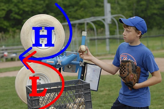
Today and tomorrow should be the last few days of warmer temperatures and elevated humidity. On Sunday we’ll have a dry cold frontal passage which will provide some relief. Beyond that is interesting.
After the front moves through on Sunday, another area of high pressure will move in behind and settle over the New England region. Low pressure is already starting to develop over Florida and should track northwards to at least the Outer Banks of North Carolina by mid-next week. Remember, lows spin counter-clockwise (cyclonic) and highs spin clockwise (anti-cyclonic) in the northern hemisphere. Therefore, what I like to call the “pitching machine” should provide strong onshore flow off the ocean next week, regardless of whether the low rides all the way up the coast or not. In this image, the upper wheel represents the high. The lower wheel represents the low. And the ball represents cooler marine air mass and wind from the ocean that will be synoptically forced towards New Jersey:
Traditionally with onshore flow, we should expect slightly higher tides than normal due to winds pushing the ocean’s surface towards New Jersey and general mid-Atlantic coast. We also tend to have cloudy skies with even a few sprinkles. I think the onshore flow will develop early next week and provide these conditions heading into the weekend. Next weekend marks the point of uncertainty as to whether the low will bring rainfall or not. Regardless, the onshore flow will sustain as long as the low is to our S with high pressure blocking to our north.
So basically, expect stiff E/NE winds off the ocean (gusting to 20-25mph), a mixed bag of sun, clouds and on-and-off rain, high temperatures in the 70s, and low temperatures in the 50s (40s for inland/elevations)…all starting Sunday PM and lasting most of next week into the weekend. I’ll be monitoring the coastal low’s track between now and then but regardless, the onshore flow forecast is fairly confident. Be safe! JC
Jonathan Carr (JC) is the founder and sole operator of Weather NJ, New Jersey’s largest independent weather reporting agency. Since 2010, Jonathan has provided weather safety discussion and forecasting services for New Jersey and surrounding areas through the web and social media. Originally branded as Severe NJ Weather (before 2014), Weather NJ is proud to bring you accurate and responsible forecast discussion ahead of high-stakes weather scenarios that impact this great garden state of ours. All Weather. All New Jersey.™ Be safe! JC

LOCAL FORECAST | INTERACTIVE RADAR | LATEST NJ WEATHER ALERTS | WEDDING FORECAST| PRIVACY POLICY
© Copyright 2025 Weather NJ LLC. All Rights Reserved.
Some information that can be found on our website is provided by a private weather station and is not an officially recognized station for weather reporting. Though we always strive to achieve accurate reporting for our own use, it is important that you do NOT depend on the data provided here for any purpose.


