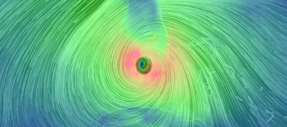
Discussion: Major Hurricane Irma made landfall this morning between Key West and Marathon, Florida as a category 4 hurricane. She has weakened into a category 3 (still very dangerous between wind speed, storm surge and heavy rainfall!) today and just made landfall in Marco Island, FL. Her immediate path should be near Naples and then Tampa into Big Bend. The W coast of FL (N of current impact zone) is still very much in for a rough night. The most destructive sustained winds remain on the W side of FL but tornadoes are occurring in the NE quadrant of the system. Her center of circulation should continue towards Tampa later this evening before crossing into Georgia tomorrow and ultimately tracking towards N Alabama and W Tennessee Tuesday into Wednesday. I expect Irma to be a weakening category 1 hurricane when crossing the Tampa<->Orlando latitude. I then expect Irma to weaken further into a tropical storm when passing through most of Georgia and ultimately a tropical depression by the time she gets into N Alabama. I expect nuisance remnants to move our way, first some rain and wind Tuesday into Wednesday (warm frontal boundary from one of Irma’s outer bands) and then some fizzling upper-level remnants for the coming weekend (isolated-to-scattered showers). Here’s the latest National Hurricane Center update for Irma:
Major Hurricane Jose is currently a category 3 well N of Puerto Rico. Model guidance has him looping like a roller coaster before possibly being swung around back in the direction that he is traveling…towards the N Bahamas. We’re talking about a week for this to happen. For Jose to then be pulled back to the W towards the Mid-Atlantic US, an upper-level low would have to track across the US/Canadian border and position itself perfectly for a capture. These dynamics are “thread the needle” and are simply too far away to make any conclusive statements about the east coast. If that scenario were to happen it wouldn’t be for about 10 days from now.
Jose could fall apart during the loop and get carried away from the trade winds->westerlies flow (to the NE). He could encounter a delayed connection with the upper-level low and possibly slam into the NE US/SE Canada. He could miss the connection entirely and completely stay out to sea. There are a lot of possibilities that could happen and therefore you should see various different solutions modeled in the coming days. Some of these solutions could include a hit to our area. Try to relax and and take everything you see with the general grain of salt. The bottom line here is that Jose track estimation outside of his immediate expected loop is highly speculative at this point. Here’s the latest National Hurricane Center update for Jose:
For an even further technical dive/model-by-model analysis, we feature the premium My Pocket Meteorologist Premium Forum (bottom option). While you’re there, have a peek at our other premium services such as our hyper-local text notification system for daily forecasts and severe weather events. Thousands of people have signed up for these services and thoroughly enjoy them, especially during the snowy winter months (snow plowers!). Not to worry, my free services (daily articles such as these and Monday-Friday/Weekend Outlooks) will always remain free as-is. The premium services simply go beyond and at the hyper-local level…mostly for outdoor business owners and the sickest weather freaks like me.
In English: Irma has made landfall in SW FL and will gradually weaken in the next few days as she tracks through Tampa, Big Bend FL, Georgia and N Alabama. Her remnants will then track towards us but will fizzle out before reaching us. Fizzling impacts could include 20mph sustained winds (gusts to 30mph) out of the SE on Tuesday (dry until about midnight), isolated-to-scattered passing showers on Wednesday, and isolated-to-scattered showers later in the weekend. I’ll have the Monday-Friday Outlook posted later this evening. Jose is 10 days away with a big IF he even comes this way. Jose’s track beyond his current location is extremely speculative. He will possibly be making a roller-coaster loop in the Atlantic over the next 5-7 days. Let’s talk in a few days, once we even know if he will make it through the loop. Have a great rest of your Sunday and please be safe! JC
Jonathan Carr (JC) is the founder and sole operator of Weather NJ, New Jersey’s largest independent weather reporting agency. Since 2010, Jonathan has provided weather safety discussion and forecasting services for New Jersey and surrounding areas through the web and social media. Originally branded as Severe NJ Weather (before 2014), Weather NJ is proud to bring you accurate and responsible forecast discussion ahead of high-stakes weather scenarios that impact this great garden state of ours. All Weather. All New Jersey.™ Be safe! JC
