

Remnant Beryl Energy Approaches NJ
Discussion: Over the past few weeks, Beryl has tracked from the Cape Verde region off NW Africa, across the Atlantic Ocean, across the Caribbean Sea, across the Yucatan Peninsula, Across the Gulf of Mexico, into the Houston area of TX, across the US (from SW to NE), and is now tracking towards Montreal, Canada. Beryl achieved its maximum strength in the W Caribbean as a category 5 major hurricane packing sustained winds of 167mph and a central low pressure of 934mb. After bringing destruction to parts of the Lesser Antilles, Jamaica, Cayman Islands, and Houston as a tropical cyclone, Beryl has transitioned into a post or extra-tropical cyclone with frontal boundaries and separate clashing air masses obeying the laws of the Norwegian Cyclone Model/conveyor belt system around its low center…indisputable evidence that it is now a cold-core extra-tropical cyclone, no longer a warm-core tropical cyclone.
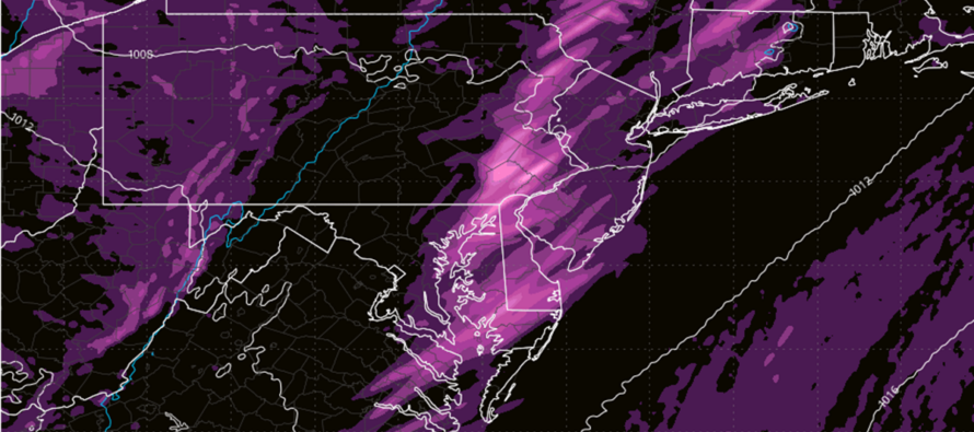
From the current look of the NE US, there appears to be your typical Great Lakes low with a cold front attached to its S side about to push through NJ. Tropical remnants, however, tend to bring an enhancement of dynamics. One of several atmospheric reasons is the enhanced cyclonic swirl that is brought into an environment not expecting the swirl. This creates lots of vertical wind shear (change in wind direction with altitude) with the strongest case of this on the E and NE quadrant of the remnant low. This sudden change in wind direction at different levels in the atmosphere is known to produce violent thunderstorms and tornadic outbreaks. Central PA into NY state saw this today. There are other enhancements that tropical remnants over land bring (cyclonic vorticity, geopotential heights, precipitable water content, humidity injection, etc.) but for those who prefer a non-scientific term, I like to call it dirty energy and I have grown to feel it. Today I felt and saw it in the form of lower atmospheric destabilization and extremely soft cumulus clouds with mini-anvils forming just above, all during a raging lower-level jet. There are simply more tornado and wind damage reports historically with remnant tropical energy than without. Dirty energy.
NJ has already lucked out some with this approaching energy. The enhanced dynamics over C PA and NY State occurred during peak diurnal heating (this afternoon). These remnant dynamics will pass over NJ tonight when the sun is down. The loss of sunlight shuts one of the engines off and should allow the downpours and thunderstorms to weaken from the Delaware River and eastward. There are a few engines remaining though…wind shear (generates atmospheric roll which provides lifting and sinking) and a moving frontal boundary (linear segment of lifting). The shear and front will still come through NJ between now and early Thursday morning. But instead of widespread severe with scattered tornadoes (like earlier in CPA/NY) it should only produce isolated severe with a low (non-zero) chance of a tornado. The downpours could be very “book of Genesis” for those hit the hardest. The NJ environment has been tropical for days and therefore we should expect tropical downpours overnight in NJ. It will be from a thin strip or two of rain along the front…so nothing drought busting. It has a better chance of run-off from the dry ground acting as a slide instead of a sponge. For this reason, flash flooding is possible. Lightning could range from sporadic to frequent depending on your proximity to stronger cells. Winds could be gusty but not as bad as earlier today for areas W and NW of NJ. Isolated severe winds possible rather than widespread. Same goes with any tornadic development…very isolated.
I expect the rain/stormfront to arrive at WNJ between 10-11pm tonight and slowly push through to ENJ by 2-3am Thursday morning. I expect WNJ to see stronger storms than ENJ due to the coastal fizzle mechanism. While short-lived, Thursday will offer some relief from the humidity. We’re back to excessive humidity by the weekend.
In English: Beryl’s remnant energy will enhance rain downpours and winds for a thin (very short) rain/stormfront pushing through New Jersey tonight. It approaches WNJ around 10-11pm tonight (Wednesday) and clears ENJ by 3am tomorrow (Thursday) morning. Showers, downpours, breezy/gusty winds, and sporadic lightning are good bets. Frequent lightning, hail, damaging wind gusts, and tornadoes are lousy bets but non-zero chances. Storms enter WNJ their strongest and exit ENJ their weakest. This will temporarily break the humidity some for Thursday but we are back to the hot dishcloth feel by this weekend. Have a great night and please be safe! JC
Premium Services
KABOOM Club offers inside info forecast discussion, your questions answered, and early storm impact maps (ahead of the public). At a buck per month, it’s an extremely feasible way to show support.
My Pocket Meteorologist (MPM), in partnership with EPAWA Weather Consulting, offers professional/commercial interests, whose businesses depend on outdoor weather conditions (snow plowing, landscaping, construction, etc.), with hyper-local text message alerts/forecasts and access to the MPM premium forum—the most comprehensive and technical forecast discussion available for PA and NJ.
Jonathan Carr (JC) is the founder and sole operator of Weather NJ, New Jersey’s largest independent weather reporting agency. Since 2010, Jonathan has provided weather safety discussion and forecasting services for New Jersey and surrounding areas through the web and social media. Originally branded as Severe NJ Weather (before 2014), Weather NJ is proud to bring you accurate and responsible forecast discussion ahead of high-stakes weather scenarios that impact this great garden state of ours. All Weather. All New Jersey.™ Be safe! JC


LOCAL FORECAST | INTERACTIVE RADAR | LATEST NJ WEATHER ALERTS | WEDDING FORECAST| PRIVACY POLICY
© Copyright 2025 Weather NJ LLC. All Rights Reserved.
Some information that can be found on our website is provided by a private weather station and is not an officially recognized station for weather reporting. Though we always strive to achieve accurate reporting for our own use, it is important that you do NOT depend on the data provided here for any purpose.
