Oct 28: First Snowflakes Possible this Weekend!

To be clear…snow accumulations are not expected. However, the chance for snow mixing in with cold rain is very possible, especially for the higher elevations of NWNJ. A low pressure disturbance will be sinking down from Canada and lifting out to the NE in the Friday-Saturday period. The main headline will be wind chills, not the few possible snowflakes that will fall between cold rain drops. Should a better phase with the coastal low occur, it would be a much stronger snow storm but as of now, that phase happens too late on current model guidance (trust me I’ll be watching for an earlier phase). Once New Jersey gets on the SW side of the northern disturbance, strong northerly winds will setup for Saturday into Sunday. We’re talking temperatures down into the 20s with wind chills possibly in the teens. Let’s look at some guidance…
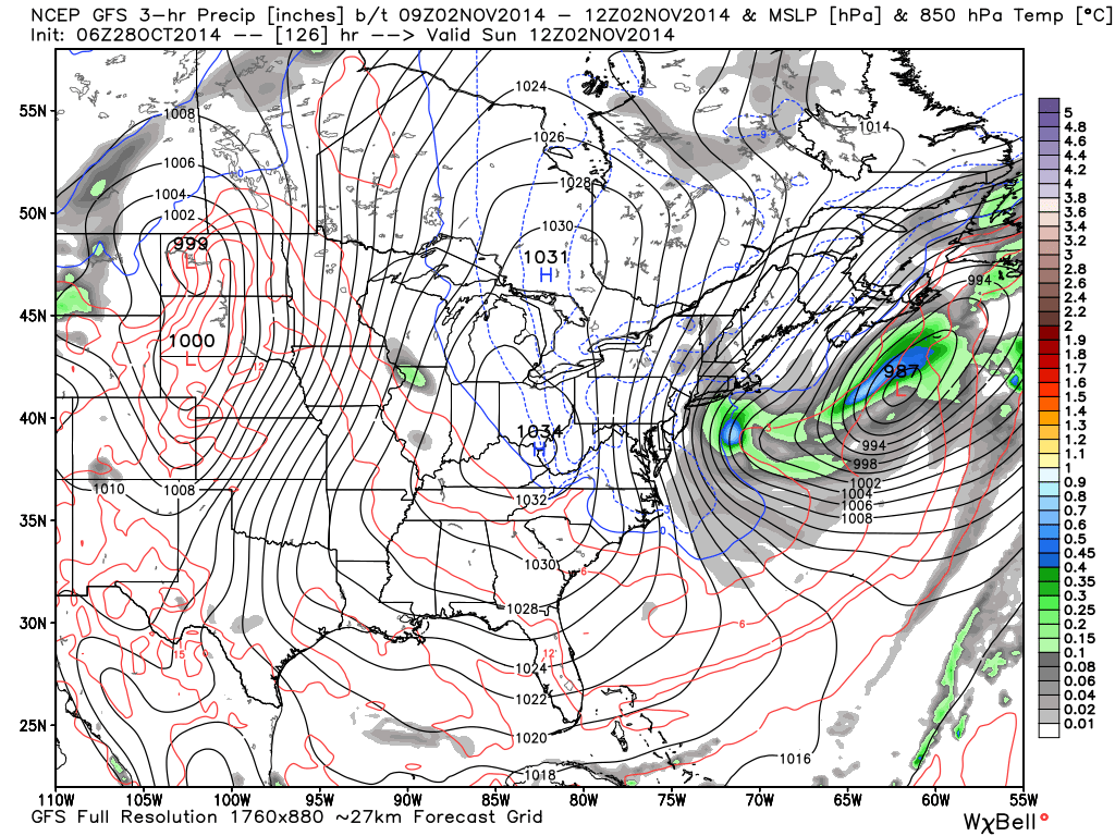
It’s important to note that not all precipitation makes it to the ground. I’ll be able to point that out better this winter but for now just understand that some precipitation can evaporate before it falls to the surface. We call this virga. This scenario is common when the lower levels of the atmosphere are dry (low dew points). This GFS slide represents liquid precipitation (in inches) and pressure (in mb) at the 850mb level (about 5,000 feet above New Jersey) between the hours of 2AM and 8AM on Sunday morning. You can see the storm pulling away with tight isobars running vertically through New Jersey…a visual recipe for strong northerly winds. The blue and red lines separate below/above freezing at that 850mb level. It’s usually slightly warmer at the surface.
I think Trick or Treat hours for the little ones will be fine for Friday. I’d wrap it all up by 9PM-10PM because the low pressure disturbance will be approaching the region and could push some rain showers ahead of it for Friday night in New Jersey. Rain should then be on-and-off overnight into Saturday. If any snowflakes are going to mix in with the rain, it will be between Saturday morning and Saturday afternoon as the temperatures drop substantially behind (to the west of) the storm. Precipitation should then taper off for Saturday night as strong northerly winds blow well into Sunday. NWNJ/interior NJ has the best chance of visible snowflakes and coastal/SENJ has the worst. The NJTP/I-95 corridor likes to split the snow/rain line more often than not (you’ll also see that later this winter). I know just the sight of snowflakes is exciting but again, wind chills will be the main story with this storm. I’ll be tracking. Be safe! JC
Jonathan Carr (JC) is the founder and sole operator of Weather NJ, New Jersey’s largest independent weather reporting agency. Since 2010, Jonathan has provided weather safety discussion and forecasting services for New Jersey and surrounding areas through the web and social media. Originally branded as Severe NJ Weather (before 2014), Weather NJ is proud to bring you accurate and responsible forecast discussion ahead of high-stakes weather scenarios that impact this great garden state of ours. All Weather. All New Jersey.™ Be safe! JC


