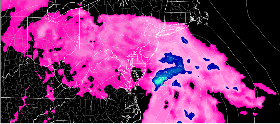
Discussion: Model guidance and live observations continue to tighten on the approaching coastal storm. The upper-levels continue the theme of an E US trough fed by the remnant energy from Willa. The surface solution has been bouncing around but the low’s track is now targeting New Jersey. This means the center of the low will likely pass over/close to New Jersey. Conditions are typically calmer at the center of a cold core mid-latitude cyclone. Very different than a warm core tropical cyclone. In order to see the center of the low however we will first have to deal with the northern side of the storm—the easterly wind component.
I expect light onset precipitation to approach Cape May by 6pm tomorrow (Friday). It might take until 9pm for light rain to begin in NNJ. Rain should become steady and moderate about 1-2 hours after the light rain begins. The heaviest stuff should generally fall between 9pm tomorrow (Friday) night and late Saturday morning. When all is said and done I expect 1-2 inches of rainfall to scatter across NJ with SENJ having the best chance to see 3 inches.
Wind will be very run of mill for an October coastal storm away from the ocean. Immediate coastal areas however are subject to 40mph+ gusts. I’m seeing a strong 850mb (about 5,000 feet up) easterly jet setting up between early Saturday AM and early Saturday afternoon. These are the hours when the highest gusts should be clocked along the ocean and for areas close to the ocean. All it takes are a few mesoscale physics to provide additional lifting and sinking air. Sinking air could bring some of the 850mb high winds down to the surface. In the worst case scenario you might see a few gusts pop north of 50mph. With that said power outages, downed trees and poles, and other typical wind hazards are in play. Again that would be for ENJ coastal areas which includes maybe 10-20 miles inland.
There is one high tide of interest for minor-to-moderate coastal flooding (primarily for ENJ coastal areas). This high tide should occur just before noon on Saturday. The easterly component with this storm system will be impressive but short. If it was for a longer period than 15-18 hours then I would be concerned about moderate-to-major coastal flooding stacking up on the second or third high tide. But in this case, minor-to-moderate coastal flooding should be the extend of the late Saturday morning high tide. Once the low passes over/close to NJ (by early Saturday afternoon) then winds will switch to the NW and begin mitigating the onshore flow-driven coastal flooding.
Conditions should gradually improve from early afternoon-forward on Saturday. You might still see clouds, pockets of light rain, mist and breezy winds through about 8pm. After that the rest of Saturday night and most of Sunday looks dry. The trend with this system has always been an earlier start time and a shorter duration of peak impact.
In English: It’s going to rain hard from Friday evening through Saturday morning. Winds are going to crank off the ocean from late Friday night through early Saturday afternoon. Minor-to-moderate coastal flooding is possible late-Saturday morning/early-Saturday afternoon. After that things wind down by Saturday night for a dry Sunday. Now-casting starts tomorrow. Be safe! JC
Jonathan Carr (JC) is the founder and sole operator of Weather NJ, New Jersey’s largest independent weather reporting agency. Since 2010, Jonathan has provided weather safety discussion and forecasting services for New Jersey and surrounding areas through the web and social media. Originally branded as Severe NJ Weather (before 2014), Weather NJ is proud to bring you accurate and responsible forecast discussion ahead of high-stakes weather scenarios that impact this great garden state of ours. All Weather. All New Jersey.™ Be safe! JC
