NJ Long Range Outlook – What to Expect for July!

It’s time to use the crystal ball and harness the WeatherTrends360 proprietary weather algorithms for a look at July 2015. But first lets break New Jersey into proper climatological regions. We have the upper elevations of NNJ/NWNJ, the interior coastal plain (SWNJ through CNJ and into NENJ), and the coastal regions (most of SENJ). I’ll be representing each climatological region with a 28-day graph from weathertrends360 data followed by a brief discussion. Please keep in mind that these algorithms are documented with an 84% verification rate and are based on oceanic water cycles and time table series.
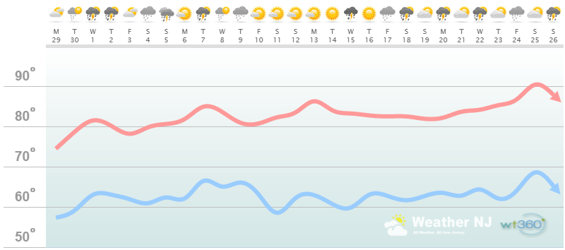
Higher Elevations of NNJ/NWNJ
(Sussex, Warren, Hunterdon, Morris, N. Somerset, and N. Passaic) – Known for little to no Atlantic Ocean influence, colder-snowier winters, and drier conditions in general when compared to the coast. This region is known to get hot when high pressure sits overhead during the summer and bitterly cold during Arctic outbreaks in the winter.
Discussion: After a dry May and wet June, temperature and precipitation trends look to even-out closer to average parameter value. While temperatures could turn out slightly below average, the strong summer sun will make it feel negligible. With that said expect high temperatures to range between 80-85 for most of the month with a warmer finish. Overnight low temperatures should mostly hover in the lower-60s with a few chilly nights dipping into the mid-to-upper 50s. The driest period looks to fall in the middle of the month with a nice stretch of sunny weather. Aside from that, expect average (frequency and intensity) showers and thunderstorms to roam through the region every few days. Nothing crazy is expected as of now but if something (severe weather) pops up, it will have to be addressed at the mesoscale level. Again, average temperatures and precipitation are expected through July 2015.
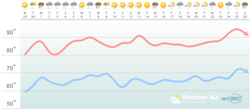
Interior Coastal Plain from SWNJ-CNJ-NENJ
(Salem, Gloucester, Camden, W. Burlington, Mercer, W. Monmouth, Middlesex, Union, Essex, Hudson, Bergen, and S. Passaic) – Known for naturally higher temperatures due to lower elevations away from the oceanic influence. This region is also known as “heat island” due to transportation (I-95 corridor), smog, abundant asphalt, concrete, and other man-made substances that naturally absorb and retain heat moreso than natural protected land.
Discussion: After a dry May and wet June, temperature and precipitation trends look to even-out closer to average parameter value. While temperatures could turn out slightly below average, the strong summer sun will make it feel negligible. With that said expect high temperatures to range between lower and upper 80s most of the month. A few days could break 90, especially towards the end of the month. I wouldn’t be surprised to see 100 broken heading into August. Overnight low temperatures should mostly hover in the upper-60s with a few warmer nights failing to dip below 70. The driest period looks to fall in the middle of the month with a nice stretch of sunny weather. Aside from that, expect average (frequency and intensity) showers and thunderstorms to roam through the region every few days. Nothing crazy is expected as of now but if something (severe weather) pops up, it will have to be addressed at the mesoscale level. Again, average temperatures and precipitation are expected through July 2015.
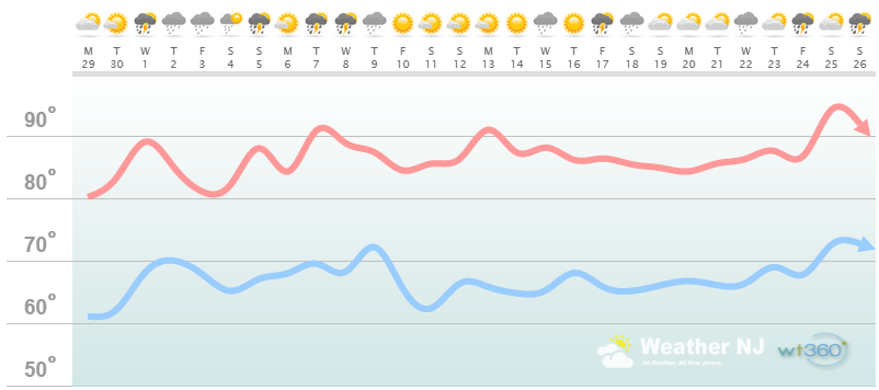
Coastal Regions of SENJ
(Cumberland, Cape May, Atlantic, E. Burlington, Ocean, and E. Monmouth) – Known for tremendous influence from the Atlantic Ocean. Oceanic influence keeps this zone cooler in the summer and warmer in the winter than the interior coastal plain and especially the higher elevations of NWNJ. This forms a micro-climate that only local inhabitants and frequent visitors are familiar with.
Discussion: After a dry May and wet June, temperature and precipitation trends look to even-out closer to average parameter value. While temperatures could turn out slightly below average, the strong summer sun will make it feel negligible. With that said expect high temperatures to range between lower 80s and upper 80s for most of the month. A few days could break 90, especially towards the end of the month. I wouldn’t be surprised to see 100 broken heading into August.
Also keep in mind that immediate coastal areas are subject to sea breeze frontal surface boundaries that back in off the ocean. These tend to happen in the afternoon hours, during peak diurnal heating, and render affected coastal portions the same temperature as the ocean surface for the rest of the afternoon-evening. Right now, the ocean is ranging in temperature (F) from 69-72 (Sandy Hook to Cape May). So on a 90F day inland, this mechanism is what provides the “natural air conditioning” feeling that shoregoers generally adore. It also makes “those who like it hot” pack up for the day lol. Regardless, it can result in a drastic temperature difference between the coast and interior. I’ll post the Rutgers temperature maps when I see one backing in off the Atlantic Ocean.
Overnight low temperatures should mostly hover in the upper-60s with a few warmer nights failing to dip below 70. The driest period looks to fall in the middle of the month with a nice stretch of sunny weather. Aside from that, expect run-of-the-mill (in frequency and intensity) showers and thunderstorms to roam through the region every few days. Nothing crazy is expected as of now but if something (severe weather) pops up, it will have to be addressed at the mesoscale level. Again, slightly-below average temperatures and average precipitation are expected through July 2015.
In English: A pretty normal July, temperature and precipitation-wise, is expected with possibly a very warm finish. All weathertrends360 algorithms point towards a longer-duration “dry period” mid-month. We’ll have plenty of showers and storms, however, as warm sectors and cold fronts move in and out—in association with relative passing low pressure disturbances.
Weathertrends360 is a complete, global, web solution to help retailers and suppliers capitalize on the weather and its influence on sales and marketing plans up to a year ahead. Learn how to become PROACTIVE vs REACTIVE with the weather in every phase of your business – how much inventory to buy/produce, where to allocate more/less, when to run weather-optimized advertising/marketing campaigns – weathertrends360 can help you determine all of this in minutes! 84% independently audited accuracy for both short-term and year-ahead forecasts for temperature and precipitation.
A forecast Weather Trends issued one year ago is more accurate than every other weather company’s 5 to 14-day forecasts. The University of Miami and West Point PhD Climatologist’s prove WTI’s year-ahead forecasts are several times more accurate than NOAA – Click to Download Report.
Enjoy the month of July and please be safe! JC
Jonathan Carr (JC) is the founder and sole operator of Weather NJ, New Jersey’s largest independent weather reporting agency. Since 2010, Jonathan has provided weather safety discussion and forecasting services for New Jersey and surrounding areas through the web and social media. Originally branded as Severe NJ Weather (before 2014), Weather NJ is proud to bring you accurate and responsible forecast discussion ahead of high-stakes weather scenarios that impact this great garden state of ours. All Weather. All New Jersey.™ Be safe! JC


