NJ Long Range Outlook – Looking at April

Before we look forward using the algorithms of weathertrends360, lets talk about where we are and how we’ve gotten here. We’re 1 week away from sustained Spring warmth but many are wondering why this hasn’t happened yet. How come? Simple! The Pacific Ocean dominates our downstream weather pattern. A stubborn trough in the E. Pacific Ocean (-EPO) and stubborn ridge over the W. US (+PNA) has kept a trough of below-average temperatures over the E. US. On the contrary, this has kept the W. US above average for temperatures. All teleconnection analysis is pointing towards a complete reversal or flip of the pattern. Between now and April 7, the E. Pacific Ocean will transition to a ridge pattern (+EPO). This will ripple downstream in the form of a trough over the W. US (-PNA) and furthermore cause a ridge to form over the E. US—bringing average to above-average temperatures to New Jersey and cooler moist weather to the W. US.
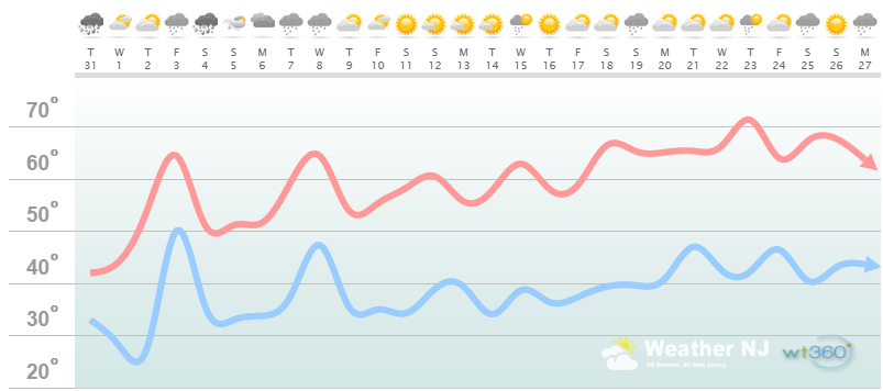
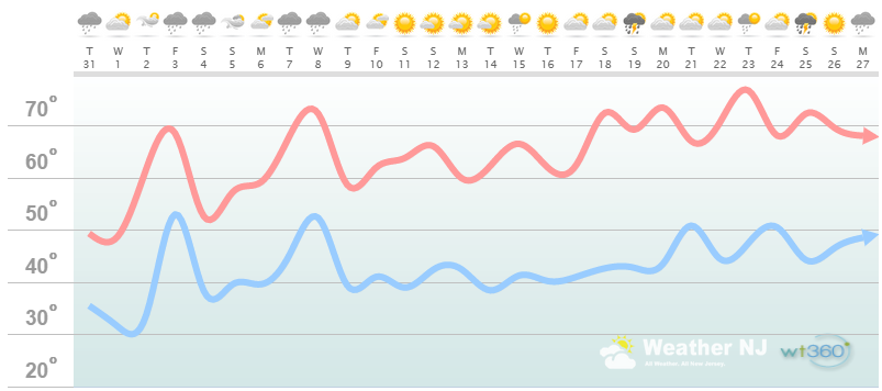
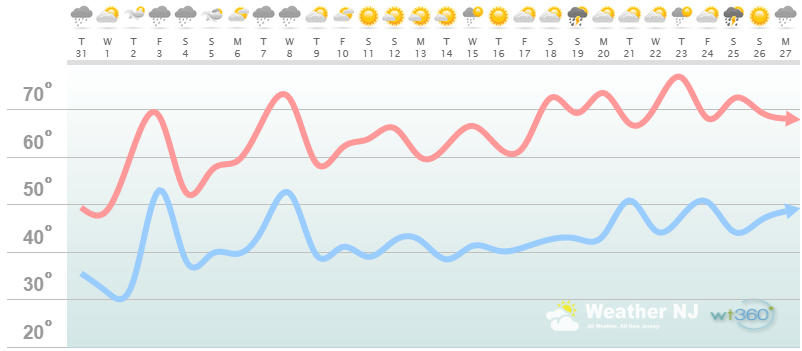
Now, lets harness the WeatherTrend360 proprietary algorithms for an even further look ahead. First lets break New Jersey into proper climatological regions. We have the upper elevations of NWNJ, the interior coastal plain (SWNJ through CNJ and into NENJ), and the coastal regions (most of SENJ). I’ll be representing each climatological region with a 28-day graph from weathertrends360 data followed by a brief discussion. Please keep in mind that these algorithms are documented with an 84% verification rate and are based on oceanic water cycles and time table series.
Zone 1: Higher Elevations of NWNJ (Sussex, Warren, Hunterdon, Morris, N. Somerset, and N. Passaic) – Known for little to no Atlantic Ocean influence, colder-snowier winters, and drier conditions in general when compared to the coast. This region is known to get hot when high pressure sits overhead during the summer and bitterly cold during Arctic outbreaks in the winter.
Zone 1 Discussion: Climatology favors this region to hold onto colder temperatures longer than other parts of New Jersey, especially this time of year. We’ll have a departing trough but that usually comes at the expense of a few back-door cold fronts. Even still, this zone is looking at 50F or greater starting April 2 and 60F or greater by the middle of the month. A few winter wrinkles, in the form of snow showers and light accumulations, will likely still exist through this upcoming weekend but that should about do it. Expect average to slightly below-average rainfall through April with most precipitation in the first half of the month. The bottom line is that high temperatures will sustain in the upper 50s and 60s starting April 4, allowing for plenty of beautiful spring weather.
Zone 2: Interior Coastal Plain (Salem, Gloucester, Camden, W. Burlington, Mercer, W. Monmouth, Middlesex, Union, Essex, Hudson, Bergen, and S. Passaic) – Known for naturally higher temperatures due to lower elevations away from the oceanic influence. This region is also known as “heat island” due to transportation (I-95 corridor), smog, abundant asphalt, concrete, and other man-made substances that naturally absorb and retain heat moreso than natural protected land.
Zone 2 Discussion: This zone could flirt with some snow showers this upcoming weekend but we can officially kiss Old Man Winter goodbye after April 2. Lows could still hover around 40 afterward but that’s obviously too warm for snow to stick. This zone will likely see a few surges into the 70s, possibly as early as this upcoming Thursday-Friday but definitely by mid-April. The bottom line is that high temperatures will sustain in the upper 50s and 60s starting this Thursday allowing for plenty of beautiful spring weather.
Zone 3: Coastal Regions (Cumberland, Cape May, Atlantic, E. Burlington, Ocean, and E. Monmouth) – Known for tremendous influence from the Atlantic Ocean. Oceanic influence keeps this zone cooler in the summer and warmer in the winter than the interior coastal plain and especially the higher elevations of NWNJ. This forms a micro-climate that only local inhabitants and frequent visitors are familiar with.
Zone 3 Discussion: This zone can officially kiss Old Man Winter goodbye as of now. It might be a bit chilly until April 2 but no more snow. This zone will likely see a few surges into the 70s, possibly as early as this upcoming Thursday-Friday but definitely by mid-April. This upcoming weekend should be the last few nights where low temperatures dip into the 30s. April looks front-loaded with precipitation for this zone with spring thunderstorms becoming active for the last third of the month. A nice period of dry, sunny and mild weather is predicted mid-month. The bottom line is that high temperatures will sustain in the upper 50s and 60s starting this Thursday allowing for plenty of beautiful spring weather.
In English: A few spring snow threats still exist but only for NNJ, especially the higher elevations. Tonight is one threat and this weekend is another (both light events). Sandwiched between will be a very mild Thursday-Friday. For the rest of NJ (lower 2/3), it’s just about time to say goodbye to Old Man Winter. The entire state can rejoice in sustained 50s and 60s after this weekend with a few surges into the 70s here and there, especially towards the end of the month. It will likely be thunderstorm-chasing season effective April 19-ish.
Weathertrends360 is a complete, global, web solution to help retailers and suppliers capitalize on the weather and its influence on sales and marketing plans up to a year ahead. Learn how to become PROACTIVE vs REACTIVE with the weather in every phase of your business – how much inventory to buy/produce, where to allocate more/less, when to run weather-optimized advertising/marketing campaigns – weathertrends360 can help you determine all of this in minutes! 84% independently audited accuracy for both short-term and year-ahead forecasts for temperature and precipitation.
A forecast Weather Trends issued one year ago is more accurate than every other weather company’s 5 to 14-day forecasts. The University of Miami and West Point PhD Climatologist’s prove WTI’s year-ahead forecasts are several times more accurate than NOAA – Click to Download Report.
Enjoy the month of April and please be safe! JC
Image from Disney’s Pirates of the Carribean obtained legally through Google Images tagged as “labeled for reuse”
Jonathan Carr (JC) is the founder and sole operator of Weather NJ, New Jersey’s largest independent weather reporting agency. Since 2010, Jonathan has provided weather safety discussion and forecasting services for New Jersey and surrounding areas through the web and social media. Originally branded as Severe NJ Weather (before 2014), Weather NJ is proud to bring you accurate and responsible forecast discussion ahead of high-stakes weather scenarios that impact this great garden state of ours. All Weather. All New Jersey.™ Be safe! JC


