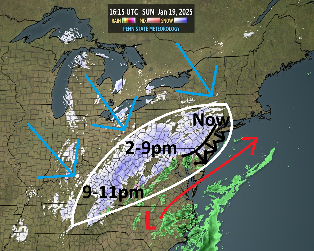
Discussion: There’s a lot to unpack on this graphic so I figured an update article is best. The storm is mostly unfolding as expected and at this time we have no changes to our going snow map. Below this image is an explanation of the pieces involved in the chicken scratch infographic:

Precipitation is a little slower to push into all of NJ than expected. Everything seems a little slower though, even the end time of snow later tonight. Thinking that tapers off W to E from 9-11pm now, possibly spilling just past midnight for ENJ.
The light blue arrows over the Great Lakes represent the very cold, Siberian-sourced Arctic air spilling out of the N Hemisphere via cross polar flow. This Arctic air will be one contributing factor to filling in and strengthening the precipitation shield.
The red L represents the current center of the surface low that will track from where it’s drawn now to S of Cape Cod by ~9-10pm tonight. As the low tracks to the NE, it will deepen from its current reading of 1006mb to about 999mb. This low strengthening is another contributing factor to filling in and strengthening the precipitation shield, as it will drive moisture from the Atlantic Ocean into the precipitation shield.
The giant slug, outlined in white, represents the precipitation shield that will push across New Jersey from SW to NE from now to the 9-11pm end time. This is what I expect to fill in over the next few hours and then maintain from about 2-9pm. To reiterate, the precip shield will fill in from clashing Arctic air and warm Atlantic Ocean moisture meeting in the middle at a snow/rain line.
Currently, the snow/rain line is where the black curved line is from NNJ down through Baltimore/DC. This is also correlating with the surface line of freezing. This line will advance SE as indicated by the black arrows.
Lastly, I labeled where we are now, where will be during the heart of precipitation and where, we’ll be later tonight as things wrap up. That’s the part of the precipitation shield that will be over NJ for that stated timeframe.
So to summarize, things are just getting started. Areas SE of 95/NJTP are a little dry to start but such areas weren’t going to accumulate snow until closer to sunset anyway when air and ground temps drop below freezing. Some reports of sleet from spotty precip down that way but no snow yet, as anticipated at this early stage of the storm. Extreme SENJ has the least expected amount of snow but nothing has changed, that snow is still expected. NNJ is off to a nice start but again, a long way to go here. The precipitation shield will continue to fill in over the next few hours and then we should be able to watch the Arctic air move through the precipitation shield as green changes to blue from NW to SE.
In English: We’re just getting started. Jackpot NWNJ areas off to a nice start. The rest of NJ won’t do much until air and temps drop closer to freezing. NENJ and the I-95 corridor/NJTP should do this next. SENJ will be last to drop to freezing closer to sunset. No changes to our going snow map at this time. Below this In English section is our going snow map for quick reference. The SNJ dry air is noted but only taking away non-accumulating mix/rain right now. It will fill in for snow time. It’s better that light rain is saturating the SNJ airspace before reaching the ground now rather than losing accumulating snow later. Watching this but all systems still operational for a SENJ snowy later (6pm to 11pm). It’s 1:15pm right now and we have a while to go. Everyone please be safe! JC
Premium Services
KABOOM Club offers ad-free content, inside info forecast discussion, your questions answered, and early storm impact maps and video releases (ahead of the public). At two bucks per month, it’s an extremely feasible way to show additional support for Weather NJ. Think of it as a tip jar with perks. Available onFacebook or Patreon.
My Pocket Meteorologist (MPM), in partnership with EPAWA Weather Consulting, offers professional/commercial interests, whose businesses depend on outdoor weather conditions (snow plowing, landscaping, construction, etc.), with hyper-local text message alerts/forecasts and access to the MPM premium forum—the most comprehensive and technical forecast discussion available for PA and NJ.
Jonathan Carr (JC) is the founder and sole operator of Weather NJ, New Jersey’s largest independent weather reporting agency. Since 2010, Jonathan has provided weather safety discussion and forecasting services for New Jersey and surrounding areas through the web and social media. Originally branded as Severe NJ Weather (before 2014), Weather NJ is proud to bring you accurate and responsible forecast discussion ahead of high-stakes weather scenarios that impact this great garden state of ours. All Weather. All New Jersey.™ Be safe! JC