

More Thunderstorms Today/Tonight!
Discussion: We’re almost to a window of relief from heat and humidity but not just yet. Last night was a solid storm night for most of CNJ/SNJ while NNJ saw more of an isolated/scattered situation. Wind intensity favored NNJ given the damage reports and lightning frequency/rainfall amounts favored SNJ. Tonight’s thunderstorm potential could pack a larger punch.
Instability is very high today from strong diurnal solar surface heating, especially across SNJ. There is little-to-no capping inversion seen on skew-t soundings but that’s sort of irrelevant due to the lifting nature of the expected stormfront passage. Dew point temperatures are 70+ for most of NJ which means plenty of surface moisture (humidity) to rise and condense into thunderstorms. Lastly, there is adequate vertical wind shear to sustain thunderstorm development through at least sundown.
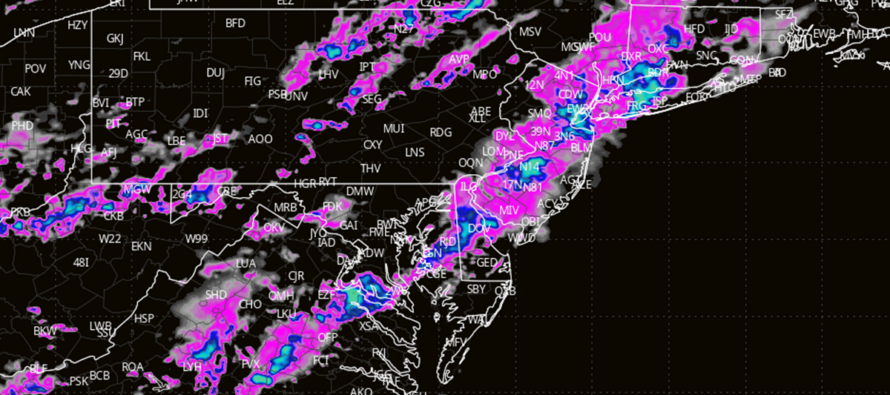
There are already some thunderstorm cells firing in extreme NNJ now (3pm Wednesday) but these are out ahead of the main anticipated storm front. The main stormfront should push through NJ between now and10pm from NW to SE (slow moving train of storms)…meaning NWNJ sees them first (soonish) and SENJ sees them last later tonight. A reasonable expectation are downpours, breezy winds, and average frequency lightning. A less probable outcome (but non-zero chance) are severe wind gusts (greater than 60mph), hail (up to an inch), and possibly a tornado. A more linear segment of thunderstorms would inhibit a tornado risk. A broken/scattered line of storms would enhance a tornado risk. We’ll have to play the radar in real-time for that.
Once this pushes through, NJ should see some relief from the heat and humidity in the form of lower temperatures and dew points. Not all of NJ should see this relief on Thursday. On Thursday, immediate coastal areas and maybe 5-10 miles inland could be held to higher humidity from marine air mass/sea breeze front influence. The rest of NJ would enjoy lower dew points (lower humidity) on Thursday. Friday would then be a “relief for all of NJ” day. It’s looking like absolutely stellar summer outdoor conditions though for Thursday and Friday minus that coastal caveat for Thursday along the coastal regions. I’ll have the full weekend outlook posted tomorrow to cover beyond Friday.
In English: More storms are likely tonight. They are just getting started in NWNJ and will slowly push SE through NENJ, WCNJ, ECNJ, and eventually SNJ/SENJ by about 10pm tonight. The storms should approach/cross I-95/NJTP around 6-8pm. Expect rain and lightning as a reasonably realistic outcomes but prepare for possible severe winds, hail, and even an isolated tornado at localized/isolated instances. These storms should break the humidity for Thursday (all but coastal NJ) and Friday (all of NJ) before we reload back to typical summery conditions by the end of the weekend. Have a great night and please be safe! JC
Premium Services
KABOOM Club offers inside info forecast discussion, your questions answered, and early storm impact maps (ahead of the public). At a buck per month, it’s an extremely feasible way to show support.
My Pocket Meteorologist (MPM), in partnership with EPAWA Weather Consulting, offers professional/commercial interests, whose businesses depend on outdoor weather conditions (snow plowing, landscaping, construction, etc.), with hyper-local text message alerts/forecasts and access to the MPM premium forum—the most comprehensive and technical forecast discussion available for PA and NJ.
Jonathan Carr (JC) is the founder and sole operator of Weather NJ, New Jersey’s largest independent weather reporting agency. Since 2010, Jonathan has provided weather safety discussion and forecasting services for New Jersey and surrounding areas through the web and social media. Originally branded as Severe NJ Weather (before 2014), Weather NJ is proud to bring you accurate and responsible forecast discussion ahead of high-stakes weather scenarios that impact this great garden state of ours. All Weather. All New Jersey.™ Be safe! JC


LOCAL FORECAST | INTERACTIVE RADAR | LATEST NJ WEATHER ALERTS | WEDDING FORECAST| PRIVACY POLICY
© Copyright 2025 Weather NJ LLC. All Rights Reserved.
Some information that can be found on our website is provided by a private weather station and is not an officially recognized station for weather reporting. Though we always strive to achieve accurate reporting for our own use, it is important that you do NOT depend on the data provided here for any purpose.
