

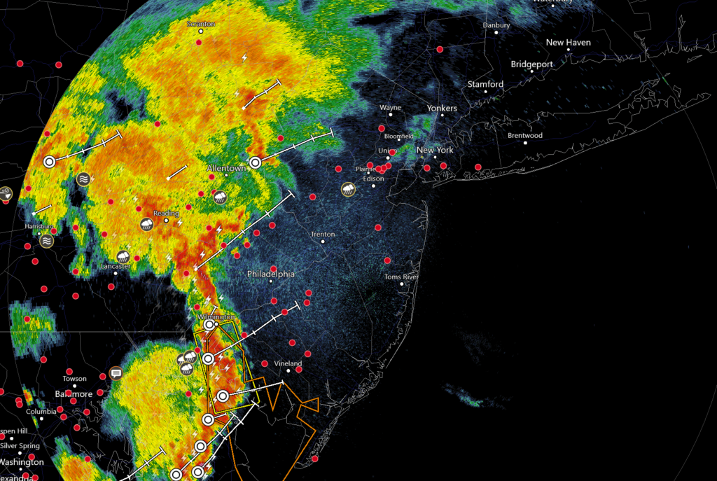
Discussion: For tonight, we remain in a warm and muggy pattern mostly from the back-side return flow of high pressure near Bermuda. This flow has coupled with weak anticyclonic energy to our W to form W/SW flow across the Appalachian Mountains. As air passes over the Apps it condenses and then re-expands on the leeward side of the mountains. This pressure drop from the leeward expansion has formed a leeward trough of lifting which is currently moving into WNJ. It’s not a cold front, just an area of lifting in a weak warm sector. These storms are meeting severe criteria and should push through NJ from W to E over the next several hours. 90% of the time these storms loose steam as they move towards the ocean. Factors such as loss of solar surface heating and marine layer interaction are usually the culprit. Storms don’t usually hold severe status to the coast because exhaust their lifting out and collapse on themselves (look for the gust front). They do however tend to hold onto heavier downpours but with less lightning and severe winds. So I’d say there’s a 90% chance of that for ENJ despite WNJ currently getting hit pretty hard. With that said there’s a 10% chance the storm line retains enough lifting to produce severe criteria thunderstorms all the way to the beach. Regardless these storms should clear the ENJ coast by the early AM hours of Friday. Here’s a current radar snapshot:

For this weekend a meridional upper-jet pattern should dominate and likely do so for much of next week too. A progressive trough should nose through the Mid-Atlantic US and set up N/NW 500mb flow from Saturday night through Tuesday morning. This should transition the current warm and humid pattern back to how it was earlier this week, mild and comfortable. I expect this transition after the final storm front moves through sometime between late Friday night and early Saturday morning. Friday, possibly into early Saturday AM, does look unsettled and stormy but serious improvement is then expected. It might take some time for the warmer humid air mass to clear out Saturday. Therefore we are majestic feeling from Saturday afternoon (possibly earlier) through all of Monday into Tuesday AM with warmer and more humid air mass returning by Tuesday afternoon. We’ll be on the front-side of a massive ridge which has an interesting back side. Cristobal has formed in the S Gulf of Mexico and is expected to make landfall in the New Orleans area ~Sunday PM. Cristobal will likely not affect NJ in any way directly but will ride up the back-side of the ridge and reinforce the south-diving high on the front-side of the ridge (our amazing weather). Cristobal should scale the US from S to N well to our W. I suppose its remnants could drag a cold front through the Mid-Atlantic US later next weekend but the center of remnant circulation should be well to the N of NJ.
Note: Unless specifically mentioned by location (Example: NNJ elevations, SENJ immediate coast, Interior CNJ/SNJ, etc.) assume the following forecast language is statewide for New Jersey.
Friday (June 5) high temperatures should reach the low-to-mid 80s for most areas. Areas away from the ocean in CNJ/SNJ could reach closer to 90. Humidity should remain elevated. Skies should be mixed with sun and clouds. Rain and thunderstorms are possible as a slow-moving cold front starts in NWNJ earlier in the day and ends in SENJ later overnight into early Saturday AM. Winds should be light out of the SW, possibly breezier along the ECNJ/SENJ coast. Obviously winds would be higher under or near a thunderstorm. Overnight lows should fall into the 60s.
Saturday (June 6) high temperatures should reach the low-to-mid 80s for most areas. Areas away from the ocean in CNJ/SNJ could reach closer to 90. Skies should start unsettled, with more rain and storms around for early-AM hours, but improve by mid-morning and forward. Humidity should also drop from morning-forward. Daylight hours should be pretty good but the true majestic-feeling stuff will probably be most felt for sunset and forward. Winds should be light out of the W (unless under or near a thunderstorm). Overnight lows should range from mid-50s to mid-60s NNJ to SNJ.
Sunday (June 7) high temperatures should reach the low-to-mid 70s. Skies should be mostly sunny with a pleasant feel (lower humidity). Winds should be light out of the N. Overnight lows should range from near-50 to near-60 NNJ to SNJ.
An early look at next week indicates the nicer stuff spilling into Monday possibly some of Tuesday. Warmth and humidity should then build again by mid-week but possibly relax a bit by the end of the week. At least Monday-Friday looks pretty dry.
Download the free Weather NJ mobile app on Apple and/or Android. It’s the easiest way to never miss Weather NJ content. Our premium services go even further above and beyond at the hyper-local level. Looking for industrial-caliber long-range forecasting data that I personally recommend? Check out WeatherTrends360! Visit the Weather NJ Kaboom Shop for hoodies, tees and infant onesies.


Jonathan Carr (JC) is the founder and sole operator of Weather NJ, New Jersey’s largest independent weather reporting agency. Since 2010, Jonathan has provided weather safety discussion and forecasting services for New Jersey and surrounding areas through the web and social media. Originally branded as Severe NJ Weather (before 2014), Weather NJ is proud to bring you accurate and responsible forecast discussion ahead of high-stakes weather scenarios that impact this great garden state of ours. All Weather. All New Jersey.™ Be safe! JC