

Discussion: Another slizzard lurks….a snow-to-sleet-to-freezing rain-to plain rain situation (depending on your NJ location) is expected tomorrow (Saturday) into Sunday morning. Here are the wintry impact maps and then we’ll break down the expectations by region again. PLEASE READ DON’T JUST LOOK AT THE MAPS.
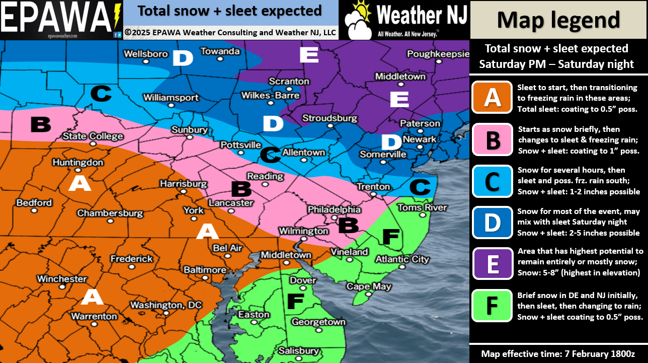
NWNJ (N of I-80 and NW of I-287): This is the jackpot snow zone. We think that totals will likely verify on the lower-end of this range, maybe even right at 5 inches. Getting closer to 8 inches is probably going to be a little further N into NY State/New England. But some guidance tells us to allow up to 8 in this zone just in case the heavier snow bands set up a little S into NNJ. It’s possible this area starts and stays all snow but we have to allow at least a brief period of ending sleet likely down along I-80 and I-287.
The rest of NNJ and CNJ (S of I-80/SE of I-287/N of I-195): Here, we’re looking at 2-5 inches of initial snow occurring mostly between Saturday afternoon and evening before changing over to sleet either late Saturday night or early Sunday AM. I would expect areas in NENJ right near NYC and areas right along I-195 to see the lower end of the range and areas closer to I-287 and just S of I-80 to see the mid-to-upper of the range.
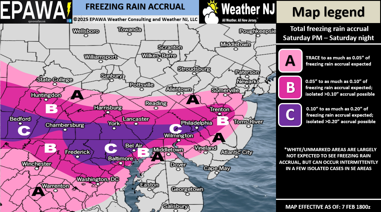
SNJ (All of NJ S of I-195): This is not a SNJ snowstorm. All snow in this area should be brief to start with little accumulation before going over to sleet/freezing rain. SWNJ should see more freezing rain to end vs. SENJ should see more rain to end. Please see the above impact maps to see where that separator runs through in SNJ (just NW of Vineland).
Timing: Timing has been frustrating given the difference across all data. The best we can do is average it into a general expectation of starting in SWNJ by Saturday afternoon. We’ll go with 2pm give or take an hour or two. By 7pm, precipitation should spread into all of NJ, including NNJ and last until sometime between early Sunday AM and sunrise on Sunday.
In English: After a rather mild day today (Friday), temperatures will drop tonight into the 20s statewide (maybe teens for NWNJ) by 7am tomorrow (Saturday) morning. On Saturday, temps will come back up to near-freezing for much of the state, a few degrees below for NNJ and possibly a few degrees above freezing for SENJ. Saturday afternoon temps should then drop again and will be reinforce-dropped by falling cold wintry precipitation that could start as early as noon but likely no later than 4pm. All of NJ could see a snowy start but only areas N of I-195 are looking at light-to-significant accumulations. Please see the snow map above. By Saturday night, most of SNJ should be over to either rain (likely SENJ) or freezing rain (likely SWNJ). Areas N of I-80 and NW of I-287 have the best chance to start and stay all snow. Lower areas of NNJ/CNJ should transition to sleet Saturday night but never go to rain. Everything should end between early Sunday AM and sunrise on Sunday in a state of: Snow for NNJ, Sleet for CNJ, freezing rain for extreme SWNJ, and rain for most of SNJ/SENJ.
We then warm back up for Sunday and Monday before temps drop again Monday night heading into the more statewide mostly snow potential Tuesday. Snow maps and forecasts for Tuesday will start on Sunday once this weekend system has cleared and we have confirmed the trailing thermal boundary in the wake of such (the track for Tuesday low to take). But for now, it still looks good and is windshield-wipering between either a statewide snowstorm or more of a CNJ/SNJ snowstorm. And then there are the remaining few signals beyond Tuesday for later next week/weekend. But let’s take one event at a time. Tomorrow morning, we may or may not tweak our forecast for tomorrow night into Sunday morning depending on any last-minute observations. If not, we’ll just start live observations on first flakes tomorrow afternoon. Have a great Friday night and please be safe! JC
Premium Services
KABOOM Club offers ad-free content, inside info forecast discussion, your questions answered, and early storm impact maps and video releases (ahead of the public). At two bucks per month, it’s an extremely feasible way to show additional support for Weather NJ. Think of it as a tip jar with perks. Available onFacebook or Patreon.
My Pocket Meteorologist (MPM), in partnership with EPAWA Weather Consulting, offers professional/commercial interests, whose businesses depend on outdoor weather conditions (snow plowing, landscaping, construction, etc.), with hyper-local text message alerts/forecasts and access to the MPM premium forum—the most comprehensive and technical forecast discussion available for PA and NJ.


Jonathan Carr (JC) is the founder and sole operator of Weather NJ, New Jersey’s largest independent weather reporting agency. Since 2010, Jonathan has provided weather safety discussion and forecasting services for New Jersey and surrounding areas through the web and social media. Originally branded as Severe NJ Weather (before 2014), Weather NJ is proud to bring you accurate and responsible forecast discussion ahead of high-stakes weather scenarios that impact this great garden state of ours. All Weather. All New Jersey.™ Be safe! JC