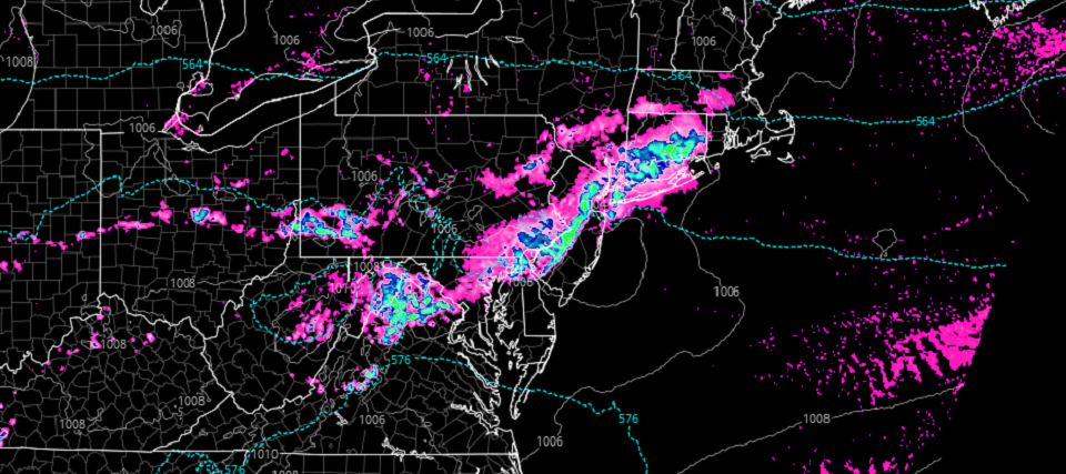
Discussion: More thunderstorms are expected today across New Jersey. It won’t be like yesterday and last night (isolated discrete supercells). It should be more of a linear segment riding a cold front. The linear thunderstorm segment looks to disrupt at least Washington DC through NYC along the I-95 corridor. Here’s the latest short-range model guidance, specifically the 3k NAM and HRRR from Tropical Tidbits:
The data shows that evening PM hours are again favored. NWNJ should be first and SENJ should be last. I expect the linear storm front to push through those areas starting at 5pm and ending before midnight. Isolated smaller thunderstorms are possible out ahead of the main event. If they happen it would be closer to afternoon hours. But the main event should indeed be tonight.
The temperature profile should have effects on storm intensity. It looks like WCNJ/SWNJ will have the greatest diurnal destabilization. The shear along the front will be adequate however for other parts of NJ. There should be a sharp contrast in temps between NENJ and SWNJ given the marine influence and its extent.
In English: More thunderstorms are possible this evening capable of producing damaging wind and hail. Straight line winds are more likely than tornadic winds with this kind of setup (different than yesterday). But you can never rule out a weak touchdown somewhere. In addition frequent lightning is possible along with heavy downpours under the strongest convection. Radar-casting will begin later today when the storms approach. Have a great day and please be safe! JC
Download the new free Weather NJ mobile app on Apple and/or Android. It’s the easiest way to never miss Weather NJ content. Our premium services go even further above and beyond at the hyper-local level. Looking for industrial-caliber long-range forecasting data that I personally recommend? Check out WeatherTrends360!
Jonathan Carr (JC) is the founder and sole operator of Weather NJ, New Jersey’s largest independent weather reporting agency. Since 2010, Jonathan has provided weather safety discussion and forecasting services for New Jersey and surrounding areas through the web and social media. Originally branded as Severe NJ Weather (before 2014), Weather NJ is proud to bring you accurate and responsible forecast discussion ahead of high-stakes weather scenarios that impact this great garden state of ours. All Weather. All New Jersey.™ Be safe! JC
