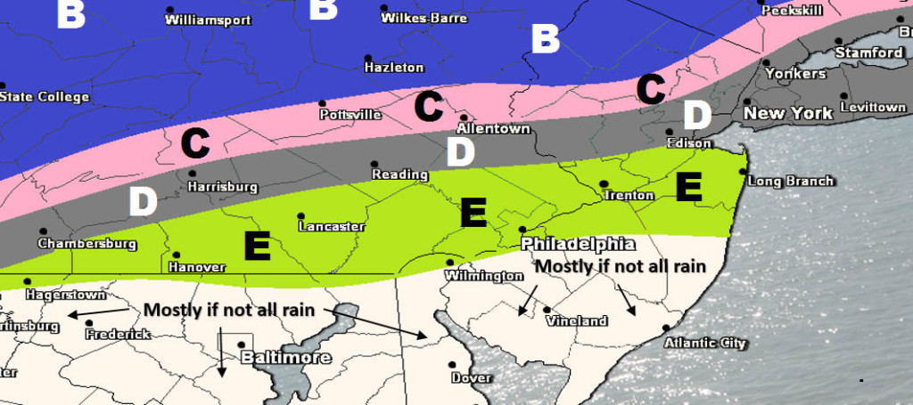
Here’s our first call on snowfall this Thursday night into Friday. Might make a few minor adjustments tomorrow for final call but likely nothing major…
Click here for full-resolution snow map.
Disco: This is a light event overall and many areas of the southern coverage region will be too warm for snow to stick. Much of SNJ could see mostly rain ending as snow. NNJ however has a chance for a few inches but even that’s going to struggle to accumulate on roads and paved surfaces. Accumulations on natural surfaces are much more probable. This should be a pasty wet light snow event. We’re not dealing with a strong low pressure center. Basically this system is a weak wave of low pressure riding a frontal boundary through the Mid-Atlantic US.
The Saturday night into Sunday system has long-disappeared to our south (for now). Whether or not it comes back up the coast for a Tuesday-Wednesday system is still yet TBD but I am watching that potential. Will have to discuss in more detail this weekend when we have a better idea of how the first two waves have actually moved through.
In English: Light snow for NNJ/mostly rain for SNJ this Thursday night-into Friday followed by a colder and drier weekend. Watching a larger winter storm possibility for next week but you all know how that goes from this range…informed discussion for now and official forecasts 2-3 days before. Have a great night and please be safe! JC
Jonathan Carr (JC) is the founder and sole operator of Weather NJ, New Jersey’s largest independent weather reporting agency. Since 2010, Jonathan has provided weather safety discussion and forecasting services for New Jersey and surrounding areas through the web and social media. Originally branded as Severe NJ Weather (before 2014), Weather NJ is proud to bring you accurate and responsible forecast discussion ahead of high-stakes weather scenarios that impact this great garden state of ours. All Weather. All New Jersey.™ Be safe! JC
