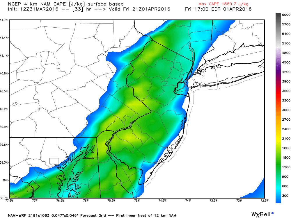
Radar confirms that precipitation has made it into W. PA. It will continue to push east and bring rainfall to New Jersey later tonight through Friday evening. I wish I could say just some wind and rain but the dynamics are potentially interesting. The latest model guidance suggests instability building late Friday afternoon into Friday evening. Surface-based CAPE (SBCAPE) appears to swell into the 1500-2000 j/kg range (as seen on the latest high-res NAM) while mixed-layer CAPE (MLCAPE) appears to swell to into the 500-800 j/kg range. The modeled lifted index (LI) is in the -1.5 to -2.0 range. All this tells me that enough instability exists to assist thunderstorm development.
About 40-50 kts of sfc-500mb bulk wind shear is modeled for the same time period as the greatest instability. This further interests me, especially with the strong lower-level jet (LLJ) at 850mb. The overall dynamics of instability and shear tell me that stronger winds aloft can be brought down to the surface and possibly trigger severe thunderstorm warnings for satisfying the 58mph or greater wind gust criteria. As far as hail goes, meh. It’s possible under concentrated and localized areas of heavy downpour. Look for the red/purple radar signatures if any appear but such is not guaranteed.
The one thing that is lacking in my opinion is a progressive cold front. We have a cold air mass moving into place for the end of the weekend and into next week. However, instead of a single low pressure system moving through to our N and dragging a fast-moving cold front through New Jersey, we have a series of low pressure disturbances that will crawl along the front of the air mass transition/invasion. The bottom line is that we have the instability and shear but a less impressive, but still existent, trigger. It could still add up however to some strong to severe thunderstorms. Once everything clears through by Friday night, the rest of the weekend appears unsettled with more rain possible Saturday before a cold and windy Sunday. I’ll have the weekend outlook posted tonight by 9PM.
In English: Today looks mild. Clouds should gradually increase into evening hours. Rain should then move in tonight and last through at least tomorrow evening. I was hoping for a Friday afternoon clearing but that is looking less likely now. Within this on-and-off rainfall exists the possibility for embedded thunderstorms. Watch out for heavy downpours and high wind gusts for any areas that do end up seeing a severe thunderstorm warning issued by the National Weather Service. I expect these areas to be localized and isolated compared to the general overall region where “just rain and wind” are the most likely conditions. I expect temperatures tomorrow to be even more mild than today. The rain should clear out by tomorrow night and make way for more mild conditions and possible rain on Saturday followed by a cold and windy Sunday. My detailed weekend outlook will be posted by 9PM tonight. Be safe! JC
Jonathan Carr (JC) is the founder and sole operator of Weather NJ, New Jersey’s largest independent weather reporting agency. Since 2010, Jonathan has provided weather safety discussion and forecasting services for New Jersey and surrounding areas through the web and social media. Originally branded as Severe NJ Weather (before 2014), Weather NJ is proud to bring you accurate and responsible forecast discussion ahead of high-stakes weather scenarios that impact this great garden state of ours. All Weather. All New Jersey.™ Be safe! JC
