

Light Snow for NNJ Tonight
Discussion: My wife and daughter have been dealing with the flu since last week. I hear there’s all sorts of bugs going around too. With that said, thank you for your patience and understanding in my update frequency. They have both turned the corner but likely have another day or two before they are ship shape. With that said, the second part of this weekend’s precipitation is looking slightly more robust for tonight.
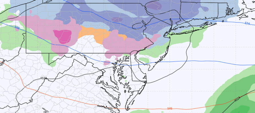
An upper-level disturbance will lead a warm front through at the surface to make for a milder Monday and start to this week. But before that happens, there’s enough lift right along and ahead of the warm front to ramp some leading/overrunning moisture up over the warm front into cold air that won’t depart the region until Monday morning. This will result in some concentrated snow showers tonight for much of the N half of NJ, with light snow accumulations possible for the N third of NJ. This arrives as early as late-afternoon today in NWNJ/by evening for NENJ and tapers off from W to E between midnight and daybreak Monday. This could produce some wintry-related travel disruption on Monday morning but with rapidly rising temps, anything that does fall and sticks will melt. I could see a few delayed openings for schools/etc. up that way but no issues in the afternoon. Let’s look at some supporting model guidance from the high-res NAM, RGEM, and HRRR:
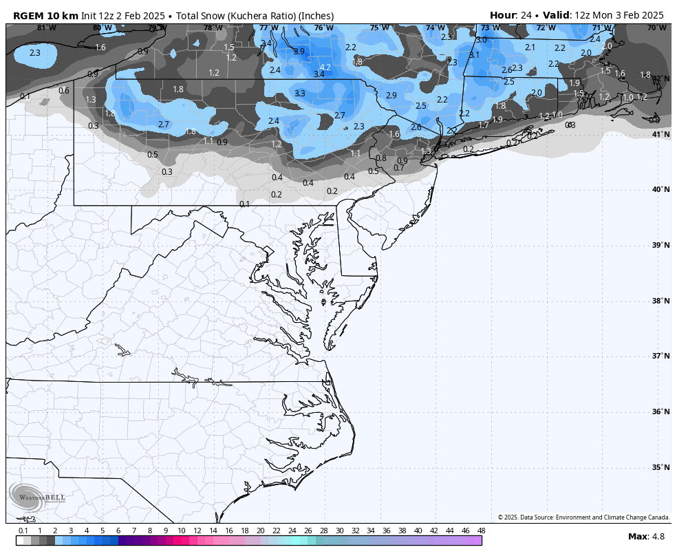
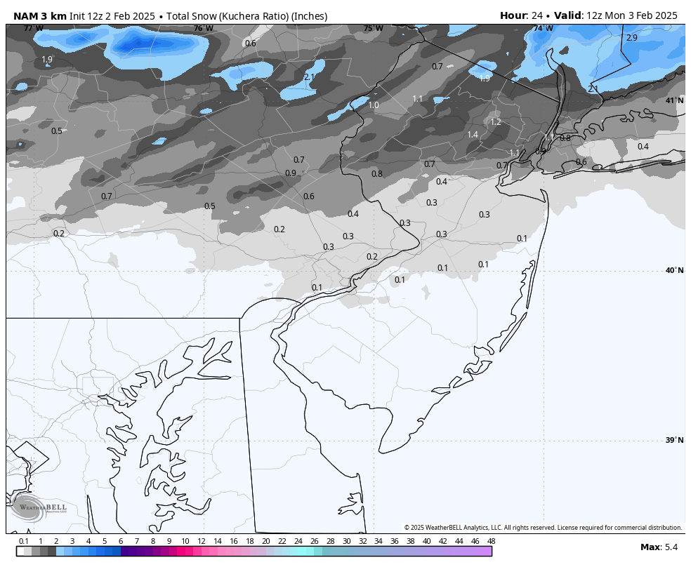
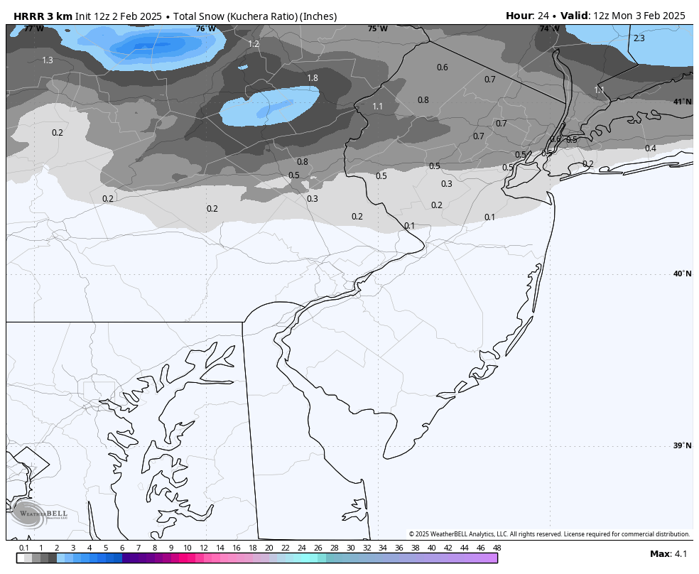
With temperatures expected to dip well into the 20s (likely lower-20s for NNJ) tonight, I’m using Kuchera snow output mode on models because that tends to handle snow ratios better when a colder snow is expected. Heck, a lot of NNJ at this time is not above freezing during peak afternoon heating hours, so tonight’ snowfall looks cold. If surface temps were going to be right around 32 tonight, I’d go with standard 10:1 snow ratios. However, with this setup tonight, NNJ, especially elevations, are looking at more of a 12:1 to 15:1 snow ratio situation. I’m going to keep geographic regional expectations very simple using lateral W to E natural division that I-80, I-78, and I-195 offer through NJ:
Along and N of I-80 (especially elevations): This should be the highest-performing zone with 2 to 4 inches of snow expected. Higher end of that range is likely achieved in the western part of this region (in highest elevations) and lower end of range in eastern part of this region (lower elevations and closer to NYC). Accumulations on untreated roads are expected here given the expected 18-24F temperatures during snowfall.
Between I-78 and I-80: This area will not as cold as N of I-80 and is more on the S side of expected precipitation. There could also be some ice mixing in at times if any sneaky warm layers nose into the lower-mid levels. With that said, between a coating and 2 inches of snow should fall here. Higher end of range on the W side (near/elevations base) and lower end of range closer to NYC. Accumulations will stack up easier on natural surfaces here than untreated roads, but some road accumulations are possible.
S of I-78: This area is on the S fringe of expected precipitation this evening/overnight. I doubt anything more than a coating would stack up here and that would likely be closer to I-78. I expect nothing more than flurries/dustings down to I-195 area (if any). Obviously, everyone S of I-195 should not expect snow from this NNJ-grazing snow shower event.
Again, it all clears out by sunrise Monday morning and rapidly rising temps should melt most of what falls. I’ll cover this more with tomorrow’s weekly outlook, but Tuesday also looks mild before all of NJ drops for the Wed-Thurs (Feb 5-6) signal. Right now, that looks like a snow/ice/rain situation with the snow/ice and ice/rain lines moving around during precipitation. By tomorrow we should have a much better idea of more specific surface expectations. For today, focus is on tonight’s NNJ snow potential. I can say though, that an onslaught of storms are expected after the Feb 5-6 signal. The next is Feb 9-10 and then one every 2-3 days through most of February. It could be a busy month once temps stabilize into more of a colder pattern after Feb 9. Until then, expect temps to roller coaster with any snow possibilities having to thread the needle during colder overnight hours.
In English: Snow is likely tonight for NNJ. 2-4” N of I-80. C-2″ between I-78 and I-80. Maybe flurries/dustings between I-195 and I-78. Expect higher ends of ranges on W side of state closer to elevations. Expect lesser ends of ranges on E side of state closer to NYC. Not much should happen snow-wise S of I-195 and there’s a small possibility that I-78 is the S extent of snow. Rain showers are possible for the non-snowy areas of SNJ/CNJ. In summary, I-80 should divide light snow accumulations likely to the N from just trace accumulation possible to the S. It arrives between late afternoon/early evening today for NWNJ and by evening for NENJ. It ends between midnight and sunrise Monday morning. Travel disruption/delays are likely for NNJ Monday morning but all wintry accumulations should melt fast as temperatures rapidly rise above freezing by mid-to-late Monday morning. We’re mild Monday-Tuesday and then eyeing up some more wintry disruption Wed-Thurs (Feb 5-6). Many signals beyond that as well. February not looking as torchy as the long-range models knee-jerked to last week. Always best to wait out the moderate reality rather than knee-jerking with the extreme long-range. I’ll start some live observations/radar posts later this evening when snow is pushing into NNJ from the W. A dull night for SNJ and lower-half of CNJ. Be safe! JC
Premium Services
KABOOM Club offers ad-free content, inside info forecast discussion, your questions answered, and early storm impact maps and video releases (ahead of the public). At two bucks per month, it’s an extremely feasible way to show additional support for Weather NJ. Think of it as a tip jar with perks. Available onFacebook or Patreon.
My Pocket Meteorologist (MPM), in partnership with EPAWA Weather Consulting, offers professional/commercial interests, whose businesses depend on outdoor weather conditions (snow plowing, landscaping, construction, etc.), with hyper-local text message alerts/forecasts and access to the MPM premium forum—the most comprehensive and technical forecast discussion available for PA and NJ.
Jonathan Carr (JC) is the founder and sole operator of Weather NJ, New Jersey’s largest independent weather reporting agency. Since 2010, Jonathan has provided weather safety discussion and forecasting services for New Jersey and surrounding areas through the web and social media. Originally branded as Severe NJ Weather (before 2014), Weather NJ is proud to bring you accurate and responsible forecast discussion ahead of high-stakes weather scenarios that impact this great garden state of ours. All Weather. All New Jersey.™ Be safe! JC


LOCAL FORECAST | INTERACTIVE RADAR | LATEST NJ WEATHER ALERTS | WEDDING FORECAST| PRIVACY POLICY
© Copyright 2025 Weather NJ LLC. All Rights Reserved.
Some information that can be found on our website is provided by a private weather station and is not an officially recognized station for weather reporting. Though we always strive to achieve accurate reporting for our own use, it is important that you do NOT depend on the data provided here for any purpose.
