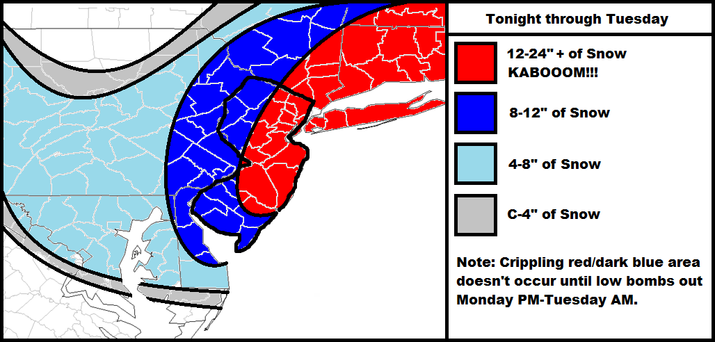
The clipper is already approaching the Ohio Valley and is looking strong! It will transfer to the OBX area, move towards the benchmark (40N/70W) and bomb out to a very strong low pressure system (sub 980mb). It might actually retrograde/stall before pulling away. This is a natural recipe for a major snow storm for New Jersey and surrounding areas. Should the storm stall longer than expected then 24″+ accumulations are possible. The term for that is “Dude, where’s my car?” —coined by New Jersey Photographer Greg Molyneux. It’s possible so we’ll leave the door open for that. Otherwise 12-24 looks about right for the hardest hit areas of New Jersey
Light snow should fall tonight and tomorrow—anything from a coating to significant snow. The main event won’t happen until later tomorrow evening into Tuesday. The coast should prepare for beach erosion and flooding on top of a potential crippling blizzard. All OEM should be advised!
In English: It’s going to snow very hard in very cold air. A foot+ is pretty much guaranteed which warrants the only true and original KABOOM! Be safe! JC
Jonathan Carr (JC) is the founder and sole operator of Weather NJ, New Jersey’s largest independent weather reporting agency. Since 2010, Jonathan has provided weather safety discussion and forecasting services for New Jersey and surrounding areas through the web and social media. Originally branded as Severe NJ Weather (before 2014), Weather NJ is proud to bring you accurate and responsible forecast discussion ahead of high-stakes weather scenarios that impact this great garden state of ours. All Weather. All New Jersey.™ Be safe! JC

