Jan 4: Winter Storm Signal Update

Well, we’re almost through our first major cold snap of the season. A period of temperature moderation is coming into fruition Wednesday through the weekend, as expected. We now turn to early next week for the much anticipated winter storm signal that’s been screaming for almost a week now.
Here’s the deal. Teleconnections still appear favorable for winter storm development next week. We have a -EPO (trough over Aleutian Islands), slightly +PNA (ridging over W. US extending northward into W. Canada), -AO (lots of cold Arctic air available), -NAO (blocking and west-based to add), and a phase 7 heading into phase 8 MJO. Up until the Scandinavian ridging and the N Atlantic superstorm last week, the Polar Vortex was wrapped up with tight winds near the N Pole (a +AO). Now it has been displaced into smaller pieces with looser winds by the arrival of higher heights (the very definition of a -AO). Therefore, I’m expecting the pattern to continue shifting to a colder and more active one for our region as we proceed through January.
Even with all this in place, we’re still left with ONLY a favorable environment for winter storm development. We still don’t have a coastal low pressure system ideally modeled out of the southern stream phasing with the northern stream within an ideal temperature profile for snow. We currently have a split flow of the jet stream coming off the Pacific Ocean which is something else you want to see if you like snow. An ideal winter storm occurs when the jets meet back up over the E coast and that’s what I’m trying to figure out for next week…the northern and southern stream interaction as well as the track and surface temperature profile. A lot depends on the track of the rainy system event modeled for this coming weekend. This will set the temperature profile for the storm early next week.
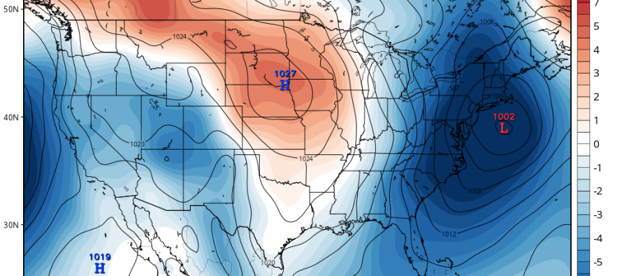
Because the system is not yet over land (energy is still over ocean), it is not yet properly sampled from the abundance of land weather sensors. Therefore, I’m hesitant to take any deterministic/operational model run seriously. By Wednesday night, the energy will be better sampled and we can start to hone in on the mid-range forecasting period of this event with operational/deterministic model output. For now, I’m using ensembles (GFS, GEM and ECM) to map the total spread of variance for the period of interest (early next week). As of right now, that’s anything from a warmer and rainier solution (inland runner track) to a track offshore (coastal snow storm). I will say that the ensembles have trended slightly warmer/westward in the last 24-hours on track variance but there’s still a strong signal closer to the benchmark on many spreads.
With that said, we’re likely going to see a synoptic storm system in the expected storm signal period early next week (between Sunday and Tuesday). The storm could drop into the 980-990mb range which would produce significant cyclonic winds and heavy precipitation. The jury however is out on precipitation type. I’ll be watching the energy come off the Pacific Ocean as well as the upper-level pattern over the next few days to gain a more confident handle on this system. For now I would relax, not taking every model run as gospel. The operational/deterministic runs are going to flip and flop. As I said, all ensembles have this system showing and the rain/snow line is far from guaranteed at the moment. Just so that everyone is prepared, this system could trend warmer or colder between now and when I get a better handle on it in a few days but it is likely coming either way. A warmer west track could still produce a significant snow storm for points to our N and W.
After the storm possibility, the middle of January through as far as I can see (3rd week of January into 4th) looks very cold as cross polar flow is expected to bring Siberian air mass into the central US which will propagate into the E US. I’m basing this off of 70mb physics, which given the axis of flow, looks to bring some seriously cold air to our region January 13-forward. Look for the Polar Vortex to eventually drop and settle in the Great Lakes/SE Canadian region. This will be the short-term warning for very cold air approaching.
In English: We’re very cold (not record breaking) tonight and through tomorrow. We moderate slightly Wednesday into the weekend (highs in 40s/low 50s). We then look to early next week for a decent storm system (rain or snow). And then we prepare for more Polar Vortex energy-influenced temperatures for the central and E US with many more snow possibilities. I’ll be watching. Be safe! JC
Jonathan Carr (JC) is the founder and sole operator of Weather NJ, New Jersey’s largest independent weather reporting agency. Since 2010, Jonathan has provided weather safety discussion and forecasting services for New Jersey and surrounding areas through the web and social media. Originally branded as Severe NJ Weather (before 2014), Weather NJ is proud to bring you accurate and responsible forecast discussion ahead of high-stakes weather scenarios that impact this great garden state of ours. All Weather. All New Jersey.™ Be safe! JC


