Snow is on the way for parts of SNJ. Here are my latest thoughts on amounts and timing…
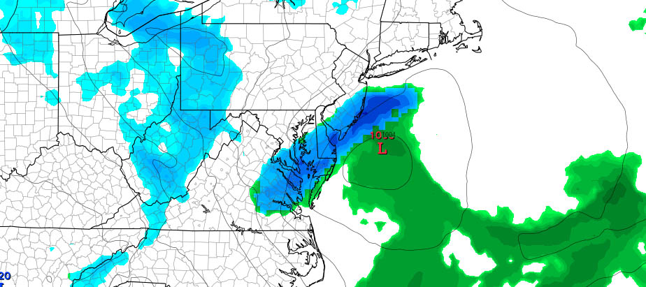
Disco: I’ve always been impressed with the upper-level setup surrounding this “first-of-four” snow possibilities this week. If you look at 500-700mb heights, there’s a solid trough of cold air swinging through. What starts as a weak clipper gets enhanced by additional energy rotating around the trough and therefore coastal development enhances the disturbance. We likely won’t see the coastal low drop below 1000mb but it should time and position perfectly to produce a light snow event targeting SENJ counties with the highest accumulations.
I’m not seeing much happening outside of SENJ. I doubt anything other than flurries will make it either N of I-195 or NW of I-95. The shorter-range model guidance I’m following right now (NAM and RGEM) are locking into this idea through Monday morning which current live observations support:
As far as timing goes, I’m not confident in this starting before midnight tonight. I’m thinking this will start shortly after midnight and wrap up by late tomorrow morning. Therefore this should time poorly with rush hour tomorrow morning, especially for SENJ counties (Cape May, Cumberland, Atlantic, E Burlington and S Ocean).
In English: A light snow event is on the way for SENJ. It should start after midnight tonight and wrap up by late morning tomorrow. I could see flurries reaching as far N as I-195 and as far NW as the NJTP but the highest accumulations should occur for Cape May, Cumberland, Atlantic, E Burlington and S Ocean Counties. Let’s go with a jackpot accumulation zone of 2-4 inches in that area. Any over-performance would have to be identified in real-time but 2-4 currently feels like the most that could happen IMO.
My Pocket Meteorologist customers will receive another round of business-critical hyper-local updates this afternoon. Otherwise, I’ll probably post some final thoughts later tonight heading into the live-casting period. Have a great Sunday and please be safe! JC
Jonathan Carr (JC) is the founder and sole operator of Weather NJ, New Jersey’s largest independent weather reporting agency. Since 2010, Jonathan has provided weather safety discussion and forecasting services for New Jersey and surrounding areas through the web and social media. Originally branded as Severe NJ Weather (before 2014), Weather NJ is proud to bring you accurate and responsible forecast discussion ahead of high-stakes weather scenarios that impact this great garden state of ours. All Weather. All New Jersey.™ Be safe! JC
