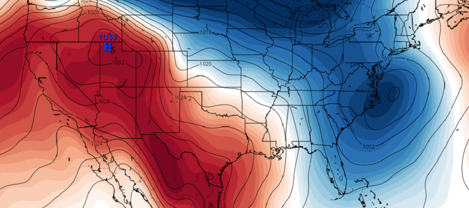
Discussion: We’re likely beyond the point of if there’s going to be a synoptic storm off the east coast this weekend. The signal has been well-advertised on long-range model guidance with consistency. A Miller-A low should form in the Gulf of Mexico, cross somewhere over the SE US and depart into the Atlantic Ocean this weekend. But this is the first critical feature of this setup and is the more confident piece.
An equally important northern stream feature (ULL) is also needed for this event to happen. Both the southern stream feature (the Miller-A low) and the northern stream feature (an Upper-Level Low (ULL) coming in from the N Plains) are modeled with confidence but it’s all going to be about the timing. And nailing down the timing will be the biggest forecasting challenge between now and storm time. A southern stream too fast would mean a warm scrape/out to sea result. Optimal northern stream interaction could make the snow lover happy statewide. Timing. Timing. Timing.
For the next 48 hours (through about Wednesday) the storm energy will complete its journey across the Pacific Ocean. There are times when the energy will pass over an abundance of buoys and sensors and times when the energy will pass over poorly-sampled ocean regions. This will result in windshield wiper effect model output at the surface from run to run. You’ll see hits like the latest GFS, yesterday’s Canadian and Saturday’s Euro. You’ll see misses like today’s earlier 12Z model suite. By Wednesday night the energy should be over western North America—no longer over the ocean. Sensor density on land, up and down the west coast, far-exceeds that over the ocean. Therefore, by Wednesday night the models will be properly sampled over land. And that’s when we’ll start taking cracks at snow maps if the system has not dropped off by then. For now we’re still watching a signal on the table. The above cover image represents 18Z GEFS mean surface pressure off the coast this weekend. The following image is from the latest 18Z GFS. Again expect many different surface solutions run-to-run over next two days. I bet no two will be the same but you’ll likely see something each time as we narrow down the possibilities:
In English: IMO you can’t make any definitive statements on this storm at this time. Come back Wednesday if that’s what you’re looking for. Can’t say it’s going to hit. Can’t rule it out. All you can say is that it’s still a strong signal and a thread the needle situation. Multiple components need to come together at the right time. If they do however then we’re looking at a beast snow storm for Saturday-Sunday. If they don’t then we could be looking at a strung out area of weak precipitation and marginal surface level temperatures at most—possibly even out to sea. I really don’t have much more to report on at the moment. We must be patient. Tomorrow let’s see how the timing of the streams has evolved but even still we’ll have another 24 hours after that before any snow projections or probabilities would be made. Have a great night and be safe! JC
Download the new free Weather NJ mobile app on Apple and/or Android. It’s the easiest way to never miss Weather NJ content. Our premium services go even further above and beyond at the hyper-local level. Looking for industrial-caliber long-range forecasting data that I personally recommend? Check out WeatherTrends360! Visit the Weather NJ Kaboom Shop for hoodies, tees and infant onesies.
Jonathan Carr (JC) is the founder and sole operator of Weather NJ, New Jersey’s largest independent weather reporting agency. Since 2010, Jonathan has provided weather safety discussion and forecasting services for New Jersey and surrounding areas through the web and social media. Originally branded as Severe NJ Weather (before 2014), Weather NJ is proud to bring you accurate and responsible forecast discussion ahead of high-stakes weather scenarios that impact this great garden state of ours. All Weather. All New Jersey.™ Be safe! JC
