For full-resolution snow map please click here!
For full-resolution ice map please click here!
For full-resolution rain map please click here!
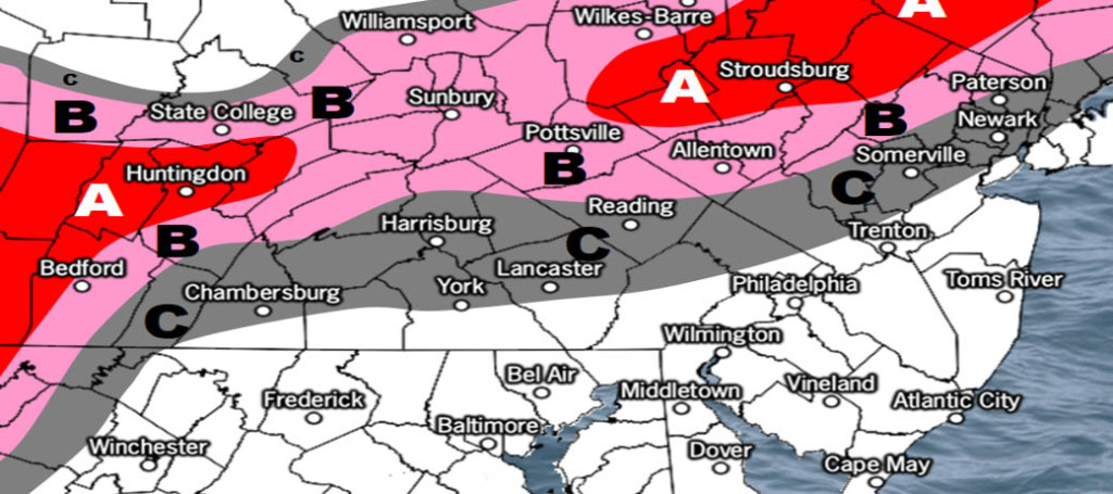
Discussion: One final update on the forecast and then we’re ready to begin live observations. The storm is approaching from our W/SW and should begin dropping precipitation by late-afternoon/early-evening today. It looks like the initial snow/rain line could set up anywhere between I-195 and I-78. That snow/rain line should then quickly advance northward into NNJ later this evening. It does appear that the initial snow thump will be less impressive than most snow lovers were hoping for. The larger safety concern for NNJ is the ice potential in the form of sleet and/or freezing rain. As the above map indicates the ice threat is primarily for those N of I-78 and NW of I-287. The A and B areas of the ice map need to take this threat seriously. It is possible that Sussex County and parts of N Warren/Morris Counties never go over to all plain rain and stay all snow/ice.
If you are along the NJTP or SE of such then you’re probably sick of hearing so much about just rain. Yes it is true you are escaping the snow, sleet and freezing rain threat. You will not likely however escape the flash flooding, thunderstorm, minor coastal flooding and later flash freeze threats Sunday evening. Parts of SENJ could reach well into the 50s maybe even 60 tomorrow (Sunday). This should create a whack instability profile which could enhance rainfall and produce thunderstorms. Flash flooding is a bad thing with how cold temperatures are expected crash Sunday night. Anything that has not yet evaporated WILL freeze. Hopefull the gusty NW winds will help dry some of the main roads and streets. Winds could become gusty at times throughout the storm and after when the cold air rushes in. Back-end snow chances are very low but not completely off the table. The primary snow threat is for NNJ only when precipitation arrives later today.
The flash freeze potential is probably the most dangerous aspect of this entire system and not just for NNJ. By midnight Sunday night all NJ surface temperatures will be below freezing. Many will be approaching zero. Like most temperature profiles in NJ, NWNJ will become the coldest the quickest and SENJ will become cold last. Again I am really hoping NW winds can evaporate as much free-standing water as possible otherwise it will be ugly Sunday night into Monday morning.
In English: The storm is approaching and snow/rain should begin falling soon. The snow/rain line should start somewhere in northern CNJ and work its way northward. The primary snow threat is for NNJ/NWNJ. The primary ice threat is for NNJ and some parts of CNJ. The primary rain threat is for the lower 2/3 of NJ especially SENJ. Please see the above maps for details. Winds could become VERY gusty especially for SNJ/SENJ. The combination of ice in NNJ and gusty winds in SNJ with temps rapidly dropping means power outages are likely. Once precipitation ends on Sunday (afternoon/early-evening) temperatures will crash big time and well-below freezing. Overnight temperatures into Monday morning should be the coldest air felt yet this season. This weekend storm is literally a pattern changer. You will feel what I am talking about Sunday night and next week. I’ll have the Monday-Friday outlook posted tomorrow. I’ll check back with live observations on social media once precipitation has begun later today. Find out why over 15,000 people have now downloaded the new free Weather NJ mobile app on Apple and/or Android. It’s the easiest way to never miss Weather NJ content. Have a great rest of your weekend and please be safe! JC
Jonathan Carr (JC) is the founder and sole operator of Weather NJ, New Jersey’s largest independent weather reporting agency. Since 2010, Jonathan has provided weather safety discussion and forecasting services for New Jersey and surrounding areas through the web and social media. Originally branded as Severe NJ Weather (before 2014), Weather NJ is proud to bring you accurate and responsible forecast discussion ahead of high-stakes weather scenarios that impact this great garden state of ours. All Weather. All New Jersey.™ Be safe! JC
