

Helene to Cripple NW Florida
Discussion: As it currently stands, there is still no threat to New Jersey from the ultimate track and path of now-formed Tropical Storm Helene. If you are only here for New Jersey weather, you could stop reading this article and miss nothing. The upper low over Arkansas as well as the high pressure/ridging is still expected to shatter apart the remnants of Helene before reaching New Jersey. However, as a passionate weather freak with an emphasis on safety first, I only ask that you pass this information to any friends, family, loved ones, etc. along the Gulf Coast, between about Pensacola, Florida and Naples, Florida. As someone who went through Sandy in 2012, I hope this information is helpful in preparing for impact of this magnitude.
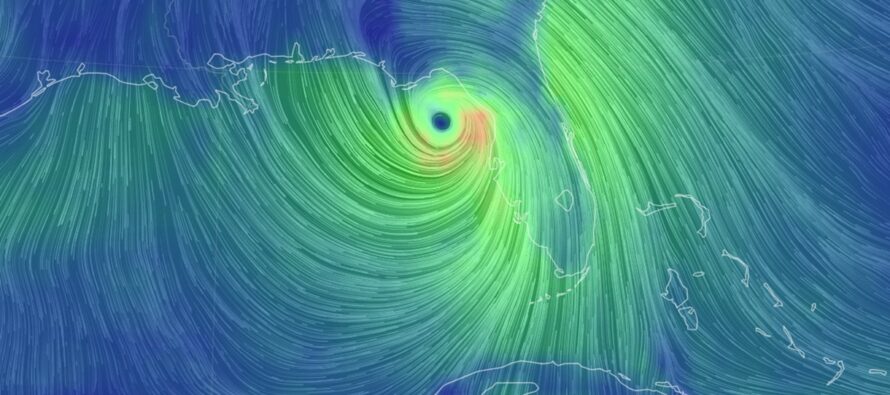
Helene was named today (Tuesday) but still just a developing tropical storm approaching the Yucatan Strait. It is now expected to become a major hurricane after passing through the Yucatan Channel and entering the wide-open warm-waters of the Gulf of Mexico tomorrow. A violent landfall in the NE Gulf Coast is becoming likely in the Wednesday PM-Thursday window…just 48 hours or less from now!
Impacts could be severe from Helene. Should major hurricane status be reached, as now expected, and maintained through landfall (possible), then we’re looking at destructive winds and life-threatening surge in the worst areas of impact. I’m not sure this is a cat 5 situation for winds, but if there were a cat 5 designation for tidal flooding, it would be a 5 for tidal flooding. The way the winds are going to team up with the coast to funnel Gulf water should be incredibly unfortunate. Don’t let the wind speed scale determine the potential impact for flooding. Many scratched their heads that Sandy was no longer designated even a cat 1 hurricane when it made landfall, and you know what happened. Should there be extra-tropical transition like Sandy, it would only expand the wind field and make NW Florida flooding worse. The moon phase will be just past a waning 3rd quarter so not likely to contribute much beyond normal astronomical tides. But rainfall could also stack on top of the tidal flooding. Again though, destructive winds (for some) and life-threatening surge (for many). A catastrophic expectation for a good chunk of the NE Gulf Coast this Thursday.
There is a very important meteorological player in the field which is the Upper-Low (UL) that will be near Arkansas. This UL has a specific timing expectation (when it will arrive) and a specific steering mechanism influence on Helene (Fujiwhara effect). I’ve personally witnessed Sandy in 2012 be pulled further W into New Jersey from an earlier capture. I’ve personally witnessed Hermine in 2016 sail off with little-to-no impact on New Jersey from a late capture. The late capture January 2015 blizzard miss. The late UL capture one week after Sandy that put snow down in ENJ. When ULs are involved, there is still wiggle room for final track from this 36-48 hour out range that we’re in now. And it is directly due to the uncertainty of UL steering dependence. These ULs move in a chaotic way like Amoebas and drive us weather people up the wall! Current model guidance is suggesting a Big Bend landfall. All I’m saying is that the expectation could easily shift a bit either towards Pensacola (less likely) or more towards Tampa (more likely). If the current data is right on then it’s right on. I’m seeing some different curves through the Yucatan Channel however which could have impacts further downstream in the re-curvature towards NW Florida. This strait land interaction is probably what will hold Helene to just tropical storm criteria until out in the Gulf. By tomorrow, the track should be more dialed in. But between now and tomorrow, keep in mind that slight track changes could still occur. And these slight changes could bring a specific location (town or city) either into the eye wall winds or out of them.
Otherwise, much of the W coast of Florida should expect tidal flooding of some level, especially as you get closer to the storm (further N along the W FL coast). Tampa Bay is not looking too good right now. Though Tampa is currently modeled just E of the most destructive winds, it’s in the the funneled area between the storm winds and the solid W FL coast. That funnel mechanism is what I believe will drive the catastrophic storm surge/tidal flooding for NW Florida. If the most destructive winds do make landfall at the big bend, that’s a less populated area. But again, a small tick in either direction could bring either Panama City or Tampa into the more destructive wind scenario.
In English: My advice for NW coastal Floridians (from Pensacola to Tampa) is this. Listen to your local authorities regarding evacuations and safety preparations. If you live on or immediately near the Gulf coast in NW Florida, you don’t have long to make and execute an evacuation plan. Landfall could happen in the Wed PM-Thursday window as a major hurricane. It is now time to finalize your plan and execute such by tomorrow afternoon. For whatever reason you can think of, staying put along the coast is not worth the risk of your life. It’s a gamble that I would not take. The storm surge potential from this, for whatever stretch of NW FL coast it hits the hardest, will likely be a GTFO or die situation. I am much more concerned about storm surge-related flooding than I am about wind speed, just like Sandy. Please pass this along to anyone you know in that area. Be safe! JC
Premium Services
KABOOM Club offers inside info forecast discussion, your questions answered, and early storm impact maps (ahead of the public). At a buck per month, it’s an extremely feasible way to show support.
My Pocket Meteorologist (MPM), in partnership with EPAWA Weather Consulting, offers professional/commercial interests, whose businesses depend on outdoor weather conditions (snow plowing, landscaping, construction, etc.), with hyper-local text message alerts/forecasts and access to the MPM premium forum—the most comprehensive and technical forecast discussion available for PA and NJ.
Jonathan Carr (JC) is the founder and sole operator of Weather NJ, New Jersey’s largest independent weather reporting agency. Since 2010, Jonathan has provided weather safety discussion and forecasting services for New Jersey and surrounding areas through the web and social media. Originally branded as Severe NJ Weather (before 2014), Weather NJ is proud to bring you accurate and responsible forecast discussion ahead of high-stakes weather scenarios that impact this great garden state of ours. All Weather. All New Jersey.™ Be safe! JC


LOCAL FORECAST | INTERACTIVE RADAR | LATEST NJ WEATHER ALERTS | WEDDING FORECAST| PRIVACY POLICY
© Copyright 2025 Weather NJ LLC. All Rights Reserved.
Some information that can be found on our website is provided by a private weather station and is not an officially recognized station for weather reporting. Though we always strive to achieve accurate reporting for our own use, it is important that you do NOT depend on the data provided here for any purpose.
