Heaviest Snow Targeting SNJ Monday

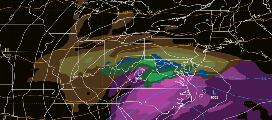
Discussion: Our light snow event for this afternoon/evening is currently moving over the Appalachian Mountains and re-establishing precipitation on the coastal plain in SW PA. This precip is what will now push across SNJ from W to E until about 8pm tonight, give or take. Only light accumulations are expected by this evening and mostly on natural surfaces. Since most of SNJ was allowed to reach the mid-to-upper 30s today, it will take some time for surface temps to cool to sticking capability. I imagine that will be around sunset (5pm-ish). As moisture moves in, it will bring temps downwards towards a rising dew point. This is known as wet bulb temperature. A coating to an inch is a good widespread expectation across SNJ with a N extent around I-195 or just S of. Within that broad C-1” area of SNJ could be a few isolated lollipops up to 2 inches of so if, and only if, the precip congeals into more of a squalling snow burst rather than just a snow shower. Thundersnow (lightning that happens from convection during snowfall) would be a good sign of it but not necessary for a squall. It all ends well before midnight and we dive deeper into the prolonged cold air mass through this weekend, leading up to the Monday period of snowstorm interest.
Like this afternoon/evening, Monday is targeting SNJ over NNJ/CNJ for the heaviest snowfall Monday. Yesterday, some guidance brought the storm N mainly due to the confluence zone being further N/NE. This morning and today, the confluence zone is modeled back to the S/SW closer to NJ. What controls this zone of confluence? The upper low in the Newfoundland area. Yesterday it was weaker and N. Today it’s stronger and S. That pushes the confluence zone down onto NNJ. On the S side of the confluence is a strip of sinking air, also called subsidence. There’s the same on the N side but that’s irrelevant to NJ interests. The S side sinking air is what will produce a sudden/steep drop off in snow accumulations somewhere between CNJ and NNJ. This is taking the area from S Warren County over to NYC, and points N of that, out of the game for plowable snow. CNJ (between I-78 and just S of I-195) is still incredibly uncertain depending on the jackpot axis of snowfall and how it interacts with the confluence to its N/NE. SNJ has always been the most heavily modeled snow third of NJ for this system. And today it remains that way. Due to proximity to the jackpot zone, SWNJ down through Atlantic City/Cape May could be looking at a heavy snowfall with SNJ just to the N of that solidly in the plowable category. The remaining question IMO is where the N extent of plowable snow will fall…closer to I-78 or closer to I-195 possibly just below I-195.
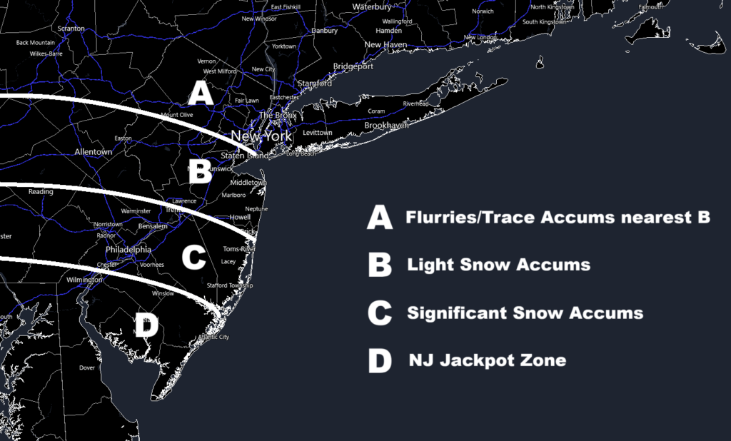
If you asked me to make a map right now, I would first tell you that the next 24 hours of model guidance will likely feature changes as energy is sampled better over land. The storm is only just coming off the Pacific Ocean over areas of more abundant weather sensors that feed into the models. There are more sensors on land than over the Pacific Ocean. Models tend to initially over-correct at this point to then correct back. So, I think there will be some more windshield wiper effect between today and tomorrow. That’s why we will not be issuing a map until tomorrow. But for my thoughts right now, this is the best I can do:

Zone A is straightforward…the area to be most likely robbed by confluence. Zone B is probably the most uncertain as it could range from trace to light accums. B areas near A could see little-to-nothing while B areas near C could see plowable snowfall. Zone C is more favored for plowable snow accumulations and Zone D even moreso due to closer proximity to jackpot zone. This is not our official forecast, which will release tomorrow. Again, this is from the hip right now with loose initial thoughts heading into snowmap time.
Timing is still Monday morning through Monday evening. In tomorrow’s snow map article, I will detail that down to a starting and ending hour. IMO, zones C and D are the plowable school closing areas for Monday. These areas will likely see Winter Storm Warnings (especially zone D) issued by the National Weather Service.
After Monday, NJ should be cold and dry at least to the start of next weekend. The good news is that it doesn’t look like record cold. It will be below-average for January (which is cold) – maybe highs ranging 25-35 and lows down to teens…but we’re not looking at any sub-zero situations. More like the cold just before Christmas. Next weekend is still being watched for another system capable of producing snow. There’s some noise about it on the latest GFS and Euro but I need to get through this Monday system first…as that ultimately becomes the 50/50 low for next weekend’s potential.
In English: Light snow is just approaching SWNJ/WCNJ and will push through to SENJ over the next 6 hours or so. Light accumulations are possible S of I-195 across all of SNJ. C-1” a reasonable expectation, possibly a little more locally/isolated under any squalls or thundersnow that could form. Monday is also targeting SNJ for the heaviest snowfall. See the above loose idea map I did without snow amounts…more of a probabilities-based thought map. Our first official snow map and forecast discussion will release tomorrow (Saturday). Today is the last day we’re monitoring for big changes on the data. Have a great rest of your Friday and please be safe! JC
Premium Services
KABOOM Club offers ad-free content, inside info forecast discussion, your questions answered, and early storm impact maps and video releases (ahead of the public). At two bucks per month, it’s an extremely feasible way to show additional support for Weather NJ. Think of it as a tip jar with perks. Available onFacebook or Patreon.
My Pocket Meteorologist (MPM), in partnership with EPAWA Weather Consulting, offers professional/commercial interests, whose businesses depend on outdoor weather conditions (snow plowing, landscaping, construction, etc.), with hyper-local text message alerts/forecasts and access to the MPM premium forum—the most comprehensive and technical forecast discussion available for PA and NJ.
Jonathan Carr (JC) is the founder and sole operator of Weather NJ, New Jersey’s largest independent weather reporting agency. Since 2010, Jonathan has provided weather safety discussion and forecasting services for New Jersey and surrounding areas through the web and social media. Originally branded as Severe NJ Weather (before 2014), Weather NJ is proud to bring you accurate and responsible forecast discussion ahead of high-stakes weather scenarios that impact this great garden state of ours. All Weather. All New Jersey.™ Be safe! JC


