Fri Snow Map and Mon Snowstorm Update

Discussion: Quite a bit to talk about today. Mainly two upcoming systems capable of producing accumulating snowfall for parts of New Jersey. Let’s dive right in.
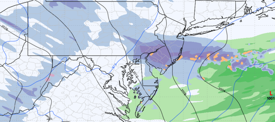
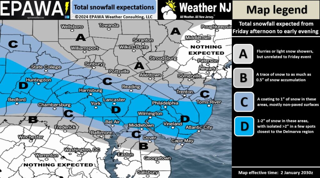
The first and most immediate system is a clipper, currently located over Iowa. This system will track across the S Great Lakes (Ohio Valley) and Appalachian Mountains tonight (Thursday) into tomorrow (Friday), and ultimately towards parts of SNJ by tomorrow afternoon/evening (Friday PM). The Appalachian Mountains will eat some of the snow up but the lake enhancement from the Great lakes should allow anything from just snow showers to full-blown squalls to occur over SNJ for Friday PM hours. Friday is going to reach temperatures in the 35-40 range for most of SNJ/SENJ during peak afternoon solar heating hours. But with loss of sun into sunset hours, temps will drop quickly to near-freezing or below, especially with snowfall involved. There’s some really cold air aloft that the snowfall will help to pull down. But with that said, the first part of Friday PM’s snow could occur with SNJ/SENJ surface temps still slightly above freezing. The second half would have a much better shot at sticking, especially on natural surfaces. Careful of non-treated roads being wet/frozen overnight. At this point, the timing looks like 4-5pm Friday to 9-10pm Friday night. I expect a general swath of a coating to an inch of snow across SNJ. That’s if only snow showers occur. However, if any squalls do form, or if there’s thundersnow, you can expect isolated/localized snow amounts higher than an inch, possibly 2 with a maximum upside of 3 inches. Again, that would be isolated areas and only if snow showers evolve into more of a squall(s). Otherwise, a coating to an inch is a reasonable and realistic expectation across SNJ by Friday night. Here’s our snow map for tomorrow (Friday) afternoon through evening:

Temperatures then drop hard into the 20s Friday overnight into Saturday with both Saturday and Sunday daytime temperatures likely staying below freezing statewide. Overnight hours should range from teens to 20s from NNJ elevations to SNJ coasts. This leads us into Monday with a very cold surface through all layers aloft over NJ.
Monday’s system is sort of a Mid-Atlantic Mauler that should track right down the Mason Dixon line extended into NJ. The system first comes off the Pacific Ocean onto N California/Oregon tomorrow (Friday) and is expected to track straight across the US from W to E with precipitation arriving sometime between mid-to-late morning Monday AM. Snowfall is expected for most of Monday with precipitation wrapping up by early Monday evening. I will provide more detailed timing as we get closer. But for now, it’s Monday morning and out Monday evening. The N extent of snowfall will be determined by the confluence zone, which is an unfavorable combining vector of wind for snowfall chances. Most models the last few days have had the confluence zone modeled too far south IMO. Only last night and today are they handling it better, hence the agreement on today’s guidance of a CNJ/SNJ hit, rather than a SNJ scrape. There’s still some time on this system to iron out the exact jackpot zone axis. But right now, that’s CNJ/SNJ. I think a widespread snow swath of 4-8 inches is likely across CNJ/SNJ with a jackpot zone of 6-12 inches. I’m not pushing KABOOM messaging on this one but it could get close with an overperformance. A solid snowstorm though. Snow maps will start either tomorrow or Saturday for the Monday system. Just know that it’s at least coming for CNJ/SNJ and it could mess up Monday morning travel interests. Again, I think there is room for this to trend further N and even bring some of NNJ into the game for accumulating snowfall. This would mean a bigger hit for CNJ and some of SNJ. This is yet TBD.
The third system I’ve been tracking in the Jan 8-12 period is losing confidence. After this Monday system, we’re going to enter another gear of cold air pouring down from the Arctic. This northerly force of cold air will likely squash out any potential coastal snowstorm for the Jan 8-12th period. We’ll see. Instead, I think the Jan 7-13 period will just feature well-below average temperatures with very little snow. The Jan 13-18 period is becoming more interesting to me. The cold is expected to last into the second half of January by way of W US and Greenland ridging. Today’s GFS model had back-to-back coastal snowstorms for the Jan 13-18 period. But yeah….snow tomorrow night, snow Monday, a week of cold, then back to a cold and stormy pattern. This seems to be the way forward from here.
In English: Light snow accumulations are possible during Friday from late-afternoon through late-evening hours. A general coating to an inch is a realistic and reasonable widespread expectation for SNJ, however some spots could do better if there are squalls or thundersnow. Maximum upside potential of 3 inches and only localized. We then turn cold for the weekend leading into a larger and more potent snowstorm targeting CNJ/SNJ between Monday morning and Monday evening. Tomorrow, we’ll start serious tracking for that. Then we have about week of cold and dry conditions before the stormy wintry pattern resumes around Jan 13-forward. For now, the above snow map is for tomorrow (Friday) afternoon-evening. Have a great rest of your Thursday and please be safe! JC
Premium Services
KABOOM Club offers ad-free content, inside info forecast discussion, your questions answered, and early storm impact maps and video releases (ahead of the public). At two bucks per month, it’s an extremely feasible way to show additional support for Weather NJ. Think of it as a tip jar with perks. Available onFacebook or Patreon.
My Pocket Meteorologist (MPM), in partnership with EPAWA Weather Consulting, offers professional/commercial interests, whose businesses depend on outdoor weather conditions (snow plowing, landscaping, construction, etc.), with hyper-local text message alerts/forecasts and access to the MPM premium forum—the most comprehensive and technical forecast discussion available for PA and NJ.
Jonathan Carr (JC) is the founder and sole operator of Weather NJ, New Jersey’s largest independent weather reporting agency. Since 2010, Jonathan has provided weather safety discussion and forecasting services for New Jersey and surrounding areas through the web and social media. Originally branded as Severe NJ Weather (before 2014), Weather NJ is proud to bring you accurate and responsible forecast discussion ahead of high-stakes weather scenarios that impact this great garden state of ours. All Weather. All New Jersey.™ Be safe! JC


