

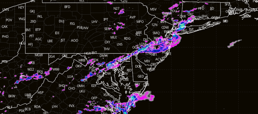
Final Stormfront Moving Through Now
Discussion: The rain and storms that have occurred so far (last night through late this morning) were associated with the warm front and warm sector attached to the overall system (low center moving through SE Canada). That’s why dew points are incredibly soupy across NJ right now (in excess of 74 degrees). We have some sunlight reaching the surface which is adding instability to the mix and there will be no shortage of atmospheric lifting with the cold front passage itself. This all spells out the potential for another round of downpours and thunderstorms (possibly severe).
This final stormfront of the system is approaching NWNJ now. It should continue to push SE, crossing the I-95/NJTP corridor around 5-6pm and ultimately the SENJ coast by 8pm or so. Once this stormfront is through then New Jersey conditions will improve big time for late Sunday night through Monday into Tuesday. But we do need to get through the next 5 or 6 hours as the storm front pushes through NJ from NW to SE. Please note that the stormfront is very thin at the moment so your storm and downpour period could vary from just 15 to 45 minutes.
Therefore (for your period of impact) I would, at the very least, expect a short period (15-45 mins) of downpours, gusty winds (up to 60mph), and rumbles (the most likely scenario). Thunderstorms can easily reach severe criteria today for either wind gusts (greater than 60mph) or hail but not guaranteed (less likely but still very probable). The least probable outcome would be tornadic activity, especially since this is a linear stormfront, but such is still small non-zero chance.
In English: The final stormfront of this system, which began last night and stormed already this morning for SNJ, will be pushing through NJ from NW to SE between now and about 8pm tonight. NWNJ just getting into it now. CNJ around 5-6pm. And then SENJ last around 8pm (give or take an hour). Storms could be severe and cause power outages via frequent lightning and/or gusty winds. Prepare for the worst, hope for the best, endure reality with an advantage. Weather conditions should then greatly improve late-tonight through Monday/Tuesday. I’ll be posting radar obs updates accordingly. Have a great night and please be safe! JC
Premium Services
KABOOM Club offers inside info forecast discussion, your questions answered, and early storm impact maps (ahead of the public). At a buck per month, it’s an extremely feasible way to show support.
My Pocket Meteorologist (MPM), in partnership with EPAWA Weather Consulting, offers professional/commercial interests, whose businesses depend on outdoor weather conditions (snow plowing, landscaping, construction, etc.), with hyper-local text message alerts/forecasts and access to the MPM premium forum—the most comprehensive and technical forecast discussion available for PA and NJ.
Jonathan Carr (JC) is the founder and sole operator of Weather NJ, New Jersey’s largest independent weather reporting agency. Since 2010, Jonathan has provided weather safety discussion and forecasting services for New Jersey and surrounding areas through the web and social media. Originally branded as Severe NJ Weather (before 2014), Weather NJ is proud to bring you accurate and responsible forecast discussion ahead of high-stakes weather scenarios that impact this great garden state of ours. All Weather. All New Jersey.™ Be safe! JC


LOCAL FORECAST | INTERACTIVE RADAR | LATEST NJ WEATHER ALERTS | WEDDING FORECAST| PRIVACY POLICY
© Copyright 2025 Weather NJ LLC. All Rights Reserved.
Some information that can be found on our website is provided by a private weather station and is not an officially recognized station for weather reporting. Though we always strive to achieve accurate reporting for our own use, it is important that you do NOT depend on the data provided here for any purpose.
