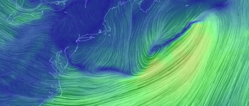
There it is. The inverted trough. Forecasting kryptonite. You can see see it animated here.
The upper-low (clipper) is moving through the E Great Lakes. It’s bringing energy around it’s southern side which is keeping the Mid-Atlantic and Northeast US under large scattered pockets of snowfall.
The inverted trough can be visually made out on the above cover image. It’s running from the Delaware Valley out to the coastal low. Follow the blue path. This linear energy has been dumping precipitation as evident by the 5-7 inch snow reports in SE PA today. Delaware and extreme SNJ saw rain from this due to warmer lower levels of the atmosphere while parts further N in SNJ saw non-accumulating snow. This area of lifting however has caused air to sink over most of New Jersey today, shredding the heavier pockets of snowfall before making it further into CNJ/NNJ. Only in the last 4-5 hours has the snow pushed N. The tells me that the inverted trough axis is tilting with the coastal low’s pit and pendulum-like swing around it’s parent clipper (in counter-clockwise motion).
I believe pockets of moderate snow will continue to move through with the clipper’s southern energy. When such pockets move over the inverted trough’s lifting, they will be enhanced into moderate-to-heavy snow bands. Just keep in mind that both the precipitation and inverted trough are both moving generally from SW to NE at differing speeds. Therefore t’s all about mesoscale timing from hereon out. Accumulations should be checkered with zero to at least light by morning for CNJ and NNJ. I think SNJ is winding up precipitation for at least now.
The surface is cold enough for CNJ and NNJ so stickage is likely. That’s been a huge factor in knocked-down accumulations today across N Delaware and SNJ. So from this point on, we watch the radar for periods of snowfall to move through from SW to NE.
Have a great night and be safe! JC
Jonathan Carr (JC) is the founder and sole operator of Weather NJ, New Jersey’s largest independent weather reporting agency. Since 2010, Jonathan has provided weather safety discussion and forecasting services for New Jersey and surrounding areas through the web and social media. Originally branded as Severe NJ Weather (before 2014), Weather NJ is proud to bring you accurate and responsible forecast discussion ahead of high-stakes weather scenarios that impact this great garden state of ours. All Weather. All New Jersey.™ Be safe! JC
