Feb 4: Ice Storm Impact Maps

Discussion: There’s no need to cover the overall global polar and Pacific patterns that are producing an unfavorable environment for winter storm development. Now it’s all about the thread-the-needle wintry events that can still occur in an unfavorable winter pattern.
We currently have a flat boundary draped across the US from W to E. When that boundary rises N of NJ we see warm temperatures and rain. When that boundary sinks S of NJ we see temperatures cold enough to support wintry precipitation. It’s not the true Arctic cold that’s bottled up in the stratospheric and tropospheric vortices but rather stale cold Canadian air that’s just cold enough. So what moves the boundary N and S? Low pressure disturbances and systems as they traverse the general boundary from W to E.
Areas in front of a cyclonic (counter-clockwise spinning) low see S flow that pushes the boundary northward. Areas behind the cyclonic low see N flow that pushes the boundary southward. And that’s what we’re dealing with this week. Right now the boundary is well N of NJ hence the warmer days yesterday and today. Today and tomorrow’s rainfall are associated with a weaker low/disturbance. Once that pushes off to the E of NJ the boundary will sink just into NNJ for Wednesday night into Thursday. It might only sink down to I-80. It might sink down to I-78 but not likely S of that.
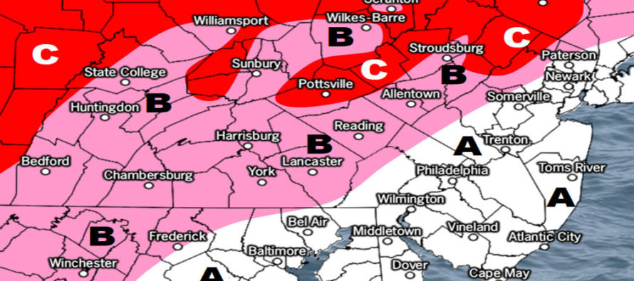
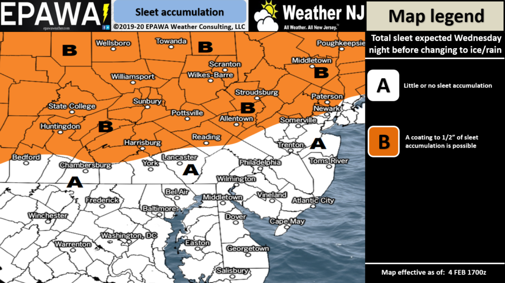
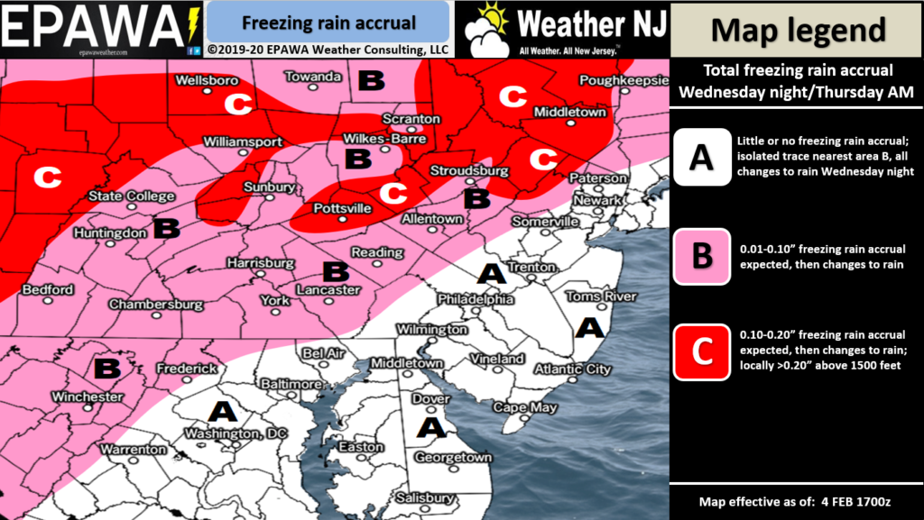
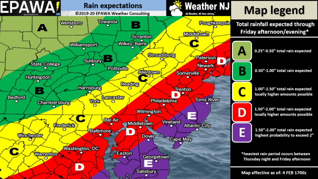
Therefore NNJ will be in the “cold enough for wintry precipitation” side of the boundary late Wednesday night/early Thursday morning while the lower 2/3 of NJ will be on the “too warm for wintry precipitation” side. During this time frame (Wed night into Thursday morning) the upper levels will be well-below freezing. The low-mid levels will be above-freezing. The surface will be just below-freezing. Precipitation should therefore start as snow in the precip-making zone, melt to rain in the warmer low-mid levels and then re-freeze in the lower-sfc levels. If it re-freezes before hitting the ground then it falls as sleet. If it hits the ground as rain and then freezes it’s called freezing rain. The depth of the warm layer is expected to start shallow and become thicker in the key precipitation time (Wed night-Thursday morning). For this reason we believe precipitation could transition from sleet first to freezing rain second. By sunrise Thursday the boundary will be heading back to the N of NJ with all precipitation (including NNJ) becoming all rain. Here’s our current forecasted impact maps separated by precipitation type. Sleet first (Wednesday night), Freezing rain (ice) second (early-Thursday morning) and lastly rain statewide:

Click here to view full-resolution sleet map!

Click here to view full-resolution ice map!

Click here to view full-resolution rain map!
Rain should then continue on-and-off statewide Thursday into Friday. That low however is expected to be stronger as it tracks just N/NW of NJ. Therefore it will be much stronger in pulling down colder air behind it for the weekend (pulling down the boundary all the way to extreme SNJ. So that’s our cold air mass source for the weekend…a transient cold shot in the form of a trough that swings through from W US to E US. This then sets up a snow event possible for late-Saturday night through early Monday morning (mainly Sunday hours). Models are kicking around anything from C-2 up to a 3-6 inch event. Once we get through the more immediate NNJ ice event Wednesday night into Thursday morning we can focus on the weekend impacts and any necessary snow maps.
In English: The main are of safety awareness concern is NNJ between late-Wednesday night into early Thursday morning. The above maps indicate how much sleet, freezing rain and plain rain will fall in this period. By rush hour Thursday morning most areas should be over to plain rain with the exception of maybe the higher elevations of NJ hanging on a few hours longer. CNJ and SNJ should be all rain throughout the entire time with SNJ favored for the highest rainfall amounts. We then observe the cold air that comes in Friday night (ending-flurries possible) as it sets up a snow event for Sunday (late-Sat PM through early-Monday AM). More to come on that once we get through this immediate NNJ ice concern. Have a great rest of your Tuesday and please be safe! JC
Download the new free Weather NJ mobile app on Apple and/or Android. It’s the easiest way to never miss Weather NJ content. Our premium services go even further above and beyond at the hyper-local level. Looking for industrial-caliber long-range forecasting data that I personally recommend? Check out WeatherTrends360! Visit the Weather NJ Kaboom Shop for hoodies, tees and infant onesies.
Jonathan Carr (JC) is the founder and sole operator of Weather NJ, New Jersey’s largest independent weather reporting agency. Since 2010, Jonathan has provided weather safety discussion and forecasting services for New Jersey and surrounding areas through the web and social media. Originally branded as Severe NJ Weather (before 2014), Weather NJ is proud to bring you accurate and responsible forecast discussion ahead of high-stakes weather scenarios that impact this great garden state of ours. All Weather. All New Jersey.™ Be safe! JC


