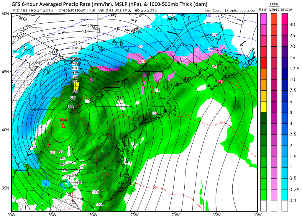
I’m getting a much better picture of how this week is going to play out weather-wise. The main low pressure system that I’ve been monitoring for Tuesday-Wednesday has trended NW with its track. Given that the energy is now getting sampled over the NW US, where many more weather sensors exist on land compared to over the Pacific Ocean, confidence is gaining in a NW track. Also, the system is a bit slower now with more of a Wednesday-Thursday AM impact than a Tuesday-Wednesday impact for New Jersey. This means a warmer and rainier system as the entire State of New Jersey becomes warm-sectored by the eastern side of the low’s cyclonic flow.
The main reason this happened is because of the high pressure location to the north of this low. Long-range model guidance originally saw this high staying directly to its north, forcing more of a coastal solution. The main trend in guidance over the weekend has been the high racing eastward too quickly. Therefore, by the time the low approaches our latitudes, it has nothing to stop it from drifting northward over the Ohio Valley and towards the eastern Great Lakes. The high was the only hope for a colder system as blocking and true cold air are simply lacking. The good news is that because of the far NW proximity of the low to the Jersey Shore, coastal flooding should not be as bad. We are looking at a prolonged period of statewide rainfall however.
With all of the focus on that Wednesday-Thursday AM low pressure system, due to its expected sub-980mb intensity, a weaker low pressure system has emerged in our near sight. This energy is just ahead of the main event later in the week. It could bring precipitation northward into New Jersey and guess what? There will be high pressure to its north—the very high pressure that is too fast for the trailing bigger system. This weaker low pressure system will be passing through Tuesday into Wednesday. It should be rain for South Jersey but I’m actually still watching North Jersey for a period of snow. I’ll be monitoring this system closely on short range model guidance over the next 24-36 hours but I wouldn’t expect much from it. The line of freezing at the surface should struggle to reach southward beyond I-78, yet alone I-80. The NAM is a bit bullish on this but other short-range guidance is also seeing the precipitation meeting colder air with the same general idea.
In English: So a drier Monday is expected with even periods of sunshine. Then rain for SNJ, possibly snow/mix for NNJ (N of I-78), is possible Tuesday into Wednesday. Wednesday into Thursday AM could then feature more rain but increased winds from the fringe E impact of the powerful low pressure system heading through the Ohio Valley and into the Great Lakes. There will be a little precipitation break if any between the weaker system (Tues-Wed) and the stronger system (Wed-Thurs AM). Once we clear on Thursday, We’re looking pretty good heading into the weekend. I’ll have the detailed Monday-Friday outlook posted early tomorrow morning but these are my general thoughts for the week. Be safe! JC
Jonathan Carr (JC) is the founder and sole operator of Weather NJ, New Jersey’s largest independent weather reporting agency. Since 2010, Jonathan has provided weather safety discussion and forecasting services for New Jersey and surrounding areas through the web and social media. Originally branded as Severe NJ Weather (before 2014), Weather NJ is proud to bring you accurate and responsible forecast discussion ahead of high-stakes weather scenarios that impact this great garden state of ours. All Weather. All New Jersey.™ Be safe! JC
