Feb 13: Ice Storm Detected

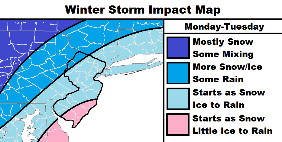
Model guidance is starting to converge on a solution for Monday into Tuesday. Here are my current thoughts. Tomorrow night’s map will have snow accumulations and ice estimations. Such values are currently too uncertain for me to estimate:
The darkest blue area should be mostly snow with only a period of mixing mid-storm.
The darker blue area should start as snow, transition to ice first then rain, finally transitioning back to snow to end.
The lighter blue area should start with a brief period of snow and a longer period of icing before changing to all rain.
The pink area should start with a possible burst of snow but quickly transition to all rain. Let’s allow just a small possibility for a brief period of ice during the transition.
Timing: Right now I’m thinking precipitation could start as early as early as noon. The changeover from snow to ice should occur Monday evening with all areas going to rain during the early AM overnight hours. With that said, travel is probably more of a concern Monday evening than Tuesday morning for most. Once over to rain, it could rain moderately to heavy with strong southerly winds. It should all taper off by Tuesday evening if not earlier.
In English: A snow to ice to rain event is likely between Monday PM hours through at least the first half of Tuesday. Most wintry impact should occur before midnight on Monday evening. My map tomorrow evening will have expected snow accumulations pre-rain as well as icing potential. Have a great night and be safe! JC
Jonathan Carr (JC) is the founder and sole operator of Weather NJ, New Jersey’s largest independent weather reporting agency. Since 2010, Jonathan has provided weather safety discussion and forecasting services for New Jersey and surrounding areas through the web and social media. Originally branded as Severe NJ Weather (before 2014), Weather NJ is proud to bring you accurate and responsible forecast discussion ahead of high-stakes weather scenarios that impact this great garden state of ours. All Weather. All New Jersey.™ Be safe! JC


