Feb 1: Final Forecast and Call for Winter Storm

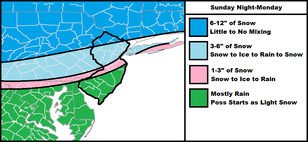
Let’s break down each color region in English:
The darker blue area furthest to the north will likely see an all snow solution with very little mixing and only on it’s southern border “if” any occurs. Otherwise, 6-12 inches of snow when all is said and done tomorrow afternoon/evening seems likely. Snow should start just before midnight tonight. Flurries could start during the game.
The lighter blue area should only see significant snowfall accumulations upon storm completion. This is the area I’m most worried about regarding sleet and freezing rain. This area should start as snow between early and late evening tonight and transition to sleet/freezing rain overnight. By late morning there could be a period of rain before everything changes back to light snow and tapers off by afternoon-evening.
The pink area is very similar to the light blue area with just less final snow accumulations given it’s southerly position. I’m also concerned about sleet and/or freezing rain for this area. Timing is also the same as light blue area with flurries possibly starting during the game.
The green area is pretty straightforward. The northern fringe of this area could start as light snow tonight but will quickly change to rain after a period of sleet and/or freezing rain…a much shorter icing period than CNJ and parts of NNJ. While this area has the smallest chance to end as snow, it has the best chance to freeze up when temperatures crash on the back side of this system. Black ice and freezing fog issues could exist tomorrow evening-overnight from such.
Overall this system has demonstrated northerly trends since it first showed up on model guidance a few days ago. The low was first modeled weak passing over the VA/NC border bringing significant snowfall to more of SNJ. Now it’s modeled to pass through SNJ. The stronger the storm the more of a NW track it takes—a very similar principal to a curveball in baseball. The faster it spins, the more of a curve it will take to its side of lesser resistance when moving from point A to point B. Regardless (and back on topic), ice is the biggest threat here IMO, especially for CNJ and parts of NNJ, not snow.
Enjoy the Super Bowl if you’re watching and use extra caution if traveling after. Chance of people driving drunk regardless of bad weather approaching = guaranteed. Be safe! JC
Jonathan Carr (JC) is the founder and sole operator of Weather NJ, New Jersey’s largest independent weather reporting agency. Since 2010, Jonathan has provided weather safety discussion and forecasting services for New Jersey and surrounding areas through the web and social media. Originally branded as Severe NJ Weather (before 2014), Weather NJ is proud to bring you accurate and responsible forecast discussion ahead of high-stakes weather scenarios that impact this great garden state of ours. All Weather. All New Jersey.™ Be safe! JC


