

Fall to Strike Back
Discussion: First we’ll talk about New Jersey this upcoming week. Then I will finish with some Hurricane Milton discussion. For this week in NJ, we have a split-flow upper jet pattern converging over the Mid-Atlantic US (analyzed at 250mb). At 500mb we can see geopotential height anomalies indicating NJ under the back-side (W side) of a departing trough giving way to a ridge. These upper-level dynamics point towards a colder source of air mass delivery which will set the stage for some traditional fall-feeling weather. It’s a very dry and clear pattern for the Mid-Atlantic US all the way through this coming weekend. It should likely force a lot of heaters on in New Jersey, especially overnight. Lots of 8) on the way.
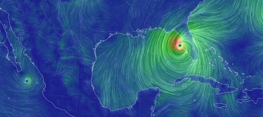
Now let’s talk about the US’s 800-pound gorilla in the room. First, Hurricane Milton will not affect New Jersey. The upper-level dynamics across the northern 2/3 of the E US will not let it come up the coast. Instead, Milton will head out to sea well to the S and E of NJ, and likely well to the SE of even OBX. Maybe some enhanced rip currents once Milton has line of sight from the Bermuda Triangle to the Jersey Shore but meh. Milton has intensified to a category 5 hurricane in the W Gulf of Mexico and is about to deliver catastrophic impact to the N/NW Yucatan Peninsula…the area that the meteor, that took out the dinosaurs, hit in case you didn’t know. This should happen tonight into tomorrow. I would expect some weakening but not much as Milton then takes aim for the W coast of FL. Right now, a landfall as a major hurricane, is expected ~Wednesday evening. This could be a much harder major hurricane blow than Helene given the population of the cities in the way of the most destructive eyewall winds (Tampa, Orlando, etc. areas). That strip across FL is much more populated than the Big Bend is. As far as the worst storm surge, it’s looking like Tampa down through Naples. Milton should then cross FL from W/SW to E/NE and eject into the Atlantic Ocean by Thursday morning somewhere near or N of Cape Canveral. There’s still some wiggle room in exact track but the Tampa area (and 100-miles N or S of) needs to take this seriously. We’re looking at another GTFO or die situation for many areas still cleaning up from Helene’s impact. Unlike Helene, we will not see excessive rainfall in the mountains. But Florida is sure looking at some rainfall. If you have friends or family along the W coast of FL, especially near Tampa, try to talk some sense into them about listening to hurricane evacuations along the coast. Also, I’m not sure how the high rises in Tampa can sustain a cat 3 or greater wind hit. By the time Milton gets to the E FL coast, it should be significantly weakened but could still be at least a category 1 hurricane.
Monday (Oct 7) high temperatures should max out in the mid-70s for most NJ locations. Skies should be mixed with sun and clouds as conditions generally improve. Winds should be light-to-breezy out of the W/NW. The ocean might still be a little rough along the beaches. Overnight lows should range from mid-40s to upper-50s from NNJ elevations to SNJ coasts.
Tuesday (Oct 8) high temperatures should struggle to escape the upper-60s for most NJ locations. Maybe just into lower-70s for some of the traditionally warmer CNJ/SNJ spots. Skies should be mixed with more sun than clouds. Winds should be light out of the NW. Overnight lows should range from 40-50 for most NJ locations but immediate ECNJ/SENJ coastal areas could hang higher in the 50s. A “fall is here” kind of night.
Wednesday (Oct 9) high temperatures should again reach the 60-70 range for highs from NNJ elevations to SNJ coasts. Skies should be mixed with sun and clouds. Winds should be light out of the W/NW. Overnight lows should range from 40-50 for most of NJ…maybe lower-50s for coasties.
Thursday (Oct 10) high temperatures should stay in the 60s statewide. Definitely a “fall is here” vibe. Skies should be mixed with more sun than clouds. Winds should be light out of the N/NW. Overnight lows should range from 40-50 for most NJ locations. I wouldn’t be surprised to see upper-30s for NNJ elevations and maybe a few interior Pine Barrens locations (mainly near Miller Air Park – 539/72 area).
Friday (Oct 11) high temperatures should reach the mid-to-upper 60s for most NJ locations. Maybe a few spots break 70. Skies should be mostly sunny. Winds should be light out of the NW. Overnight lows should range from 45-55 from NNJ elevations to SNJ coasts.
An early look at the weekend (Oct 12-13) indicates fall perfection IMO. Highs in the low-to-mid 70s. Overnight lows in the 40s/50s. Low humidity and clear skies. Let’s take another look in a few days. Everyone have a great week and please be safe! JC
Premium Services
KABOOM Club offers inside info forecast discussion, your questions answered, and early storm impact maps (ahead of the public). At a buck per month, it’s an extremely feasible way to show support.
My Pocket Meteorologist (MPM), in partnership with EPAWA Weather Consulting, offers professional/commercial interests, whose businesses depend on outdoor weather conditions (snow plowing, landscaping, construction, etc.), with hyper-local text message alerts/forecasts and access to the MPM premium forum—the most comprehensive and technical forecast discussion available for PA and NJ.
Jonathan Carr (JC) is the founder and sole operator of Weather NJ, New Jersey’s largest independent weather reporting agency. Since 2010, Jonathan has provided weather safety discussion and forecasting services for New Jersey and surrounding areas through the web and social media. Originally branded as Severe NJ Weather (before 2014), Weather NJ is proud to bring you accurate and responsible forecast discussion ahead of high-stakes weather scenarios that impact this great garden state of ours. All Weather. All New Jersey.™ Be safe! JC


LOCAL FORECAST | INTERACTIVE RADAR | LATEST NJ WEATHER ALERTS | WEDDING FORECAST| PRIVACY POLICY
© Copyright 2026 Weather NJ LLC. All Rights Reserved.
Some information that can be found on our website is provided by a private weather station and is not an officially recognized station for weather reporting. Though we always strive to achieve accurate reporting for our own use, it is important that you do NOT depend on the data provided here for any purpose.
